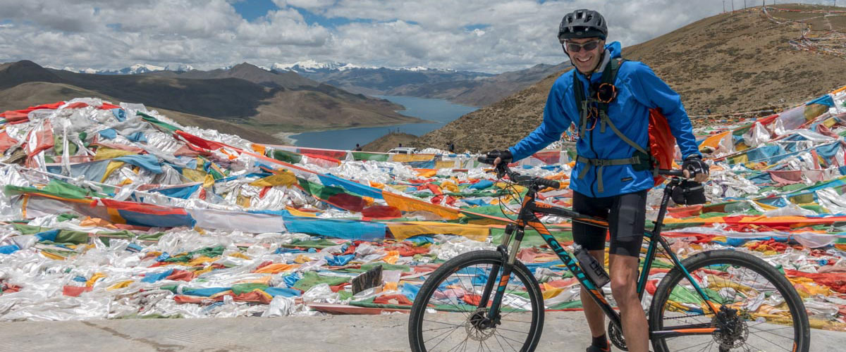

The Great Indian Himalaya Bicycle Journey
Cycling in Ladakh, Zanskar & Himachal Pradesh (Spiti, Lahaul & Kinnaur)!
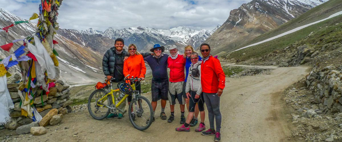
One of the Indian Himalaya’s most spectacular, cultural and diverse cycling trips, we’re excited to offer this exploratory bicycle journey along ancient salt-trade routes, from Ladakh and Zanskar through Himachal Praesh. During this epic journey, we bike over the Shingo La pass, and cycle through historic, Buddhist Spiti, Lahaul and Kinnaur (Himachel Pradesh). As roads begin to connect far-flung villages, the Indian Himalaya becomes a mecca for cycling. For Trans-Himalayan history enthusiasts, and those interested in Tibetan Buddhist regions, the districts of Spiti, Kinnaur and Lahaul have lots to offer! Of course, we camp in our signature ‘Kamzang Style’, enjoying scenic mornings, leisurely afternoons and the rosy alpenglow in the evenings on our wonderful Indian Himalaya cycling trip …
Starting our bicycle journey in Leh, we cycle south west along the newly constructed mountain road following the ‘Chadar’ (frozen Zanskar River) route, connecting Ladakh with fabled Zanskar, one of the Indian Himalaya’s most remote regions. After great cycling and explorations in Zanskar, we look forward to our epic crossing of the Shingo La, a glaciated pass leading to Lahaul, Spiti and Kinnaur, once-remote districts of mountainous, diverse Himachel Pradesh. More Himalayan passes to cross as we explore this breathtakingly beautiful, often other-worldly, region of the Indian Himalaya.
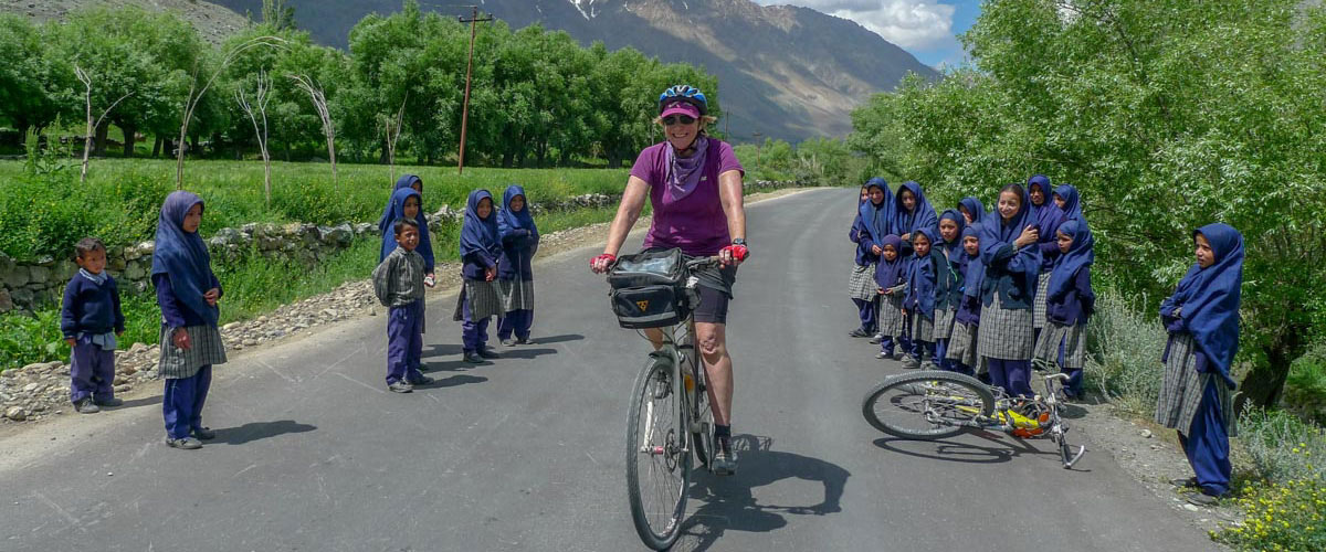
The scenery throughout the cycling trip is breathtakingly beautiful, the campsites idyllic, the roads mostly smaller country roads perfect for bicycling. We’ll see few tourists as we explore some of the Indian Himalaya’s most interesting regions, and we have plenty of time for chai in small villages, shopping at local fruit and vegetable markets and cold beers in the evenings at camp …
Summers in the Indian Himalaya are wonderful. Campsites are green and breathtakingly beautiful, cycling days are long and sunny, traditional villages are bustling with activity, glacial rivers sparkle and Himalayan panoramas from the passes are spectacular. The nomadic settlements we encounter along the way are timeless, vignettes Ladakh and Zanskar from centuries past. There is always plenty of extra time built in for exploration on our cycling trips, a photographer’s dream!
Explore all of our awesome Kamzang Journeys guided Himalayan cycling trips!
Cycle the Himalaya
Trip
The Great Indian Himalaya Bicycle Journey | Cycling in Ladakh, Zanskar & Himachal Pradesh (Spiti, Lahaul & Kinnaur), the Indian Himalaya!
Day 1 – Sunday, 14 June 2026 – Meet in Leh 3500m | Assemble or Rent Bicycles
Day 2 – Leh | Historic Cycle Tour (Shanti Stupa, Gompa Village, Gompa Monastery & Leh Fort)
Day 3 – Leh | Historic Cycle Tour Indus Valley Eastern Monasteries (Spikuk, Stakna, Thiksey & Shey) or Cycle Tour Stok Palace & Stok Valley
Day 4 – Bike Kaya 3327m (Ladakh) (72 km)
Day 5 – Bike Nyeraks Sumdo & Nyeraks 3677m (Zanskar) (63 km)
Day 6 – Bike Zangla River Camp 3435m (43 km)
Day 7 – Bike Stongde, Padum & Mune 3823m (Zanskar) | Optional Bike Stongde Gompa (55 km)
Day 8 – Bike Tangze 3978m (Zanskar) (44.7 km)
Day 9 – Bike Bike Kargiak & Lakhang Valley Camp 4480m (Zanskar) | Half Rest Day (24.4 km)
Day 10 – Bike Palamo & Jispa Camp 3270m (Lahaul) | Cross Shingo La 5035m (57 km)
Day 11 – Bike Keylong, Sissu & Atal Tunnel. Bike or Drive Gramphoo Food Truck Camp 3320m (Lahaul) (71 km)
Day 12 – Bike Chhatru & Batal 4,060m (Lahaul) (48 km)
Day 13 – Bike Losar 4095m (Spiti) | Cross Kunzum La 4540m (32 km)
Day 14 – Bike Chicham & Kibber 4106m (Spiti) (41 km)
Day 15 – Bike Kye Gompa, Kaza & Lhalung Gompa 3,725m (Spiti) (45 km)
Day 16 – Bike Dhankar & Bike Mane Gongma 3565m (Spiti) (27 km)
Day 17 – Bike Poh, Tabo Gompa & Gue (Spiti) | Visit Gue Mummy 3607m (59 km)
Day 18 – Bike Mailling Gompa 3660m(Kinnaur) | Cross Nako La | Visit Nako (44 km)
Day 19 – Bike Pooh (Poo, Spuwa) & Bee Hive Camp 2205m (Kinnaur) (81 km)
Day 20 – Bike Reckong Peo & Kalpa 2,824m (Kinnaur) (28 km)
Day 21 – Extra Cycling Days | Bike Akpa, Pangi & Sangla (Chamba)
Day 22 – Bike (& Drive) Sarahan 2160m (Shimla) (94 km)
Day 23 – Bike Rampur 979m (Shimla) (54 km)
Day 24 – Drive Shimla 2150m (125 km)
Day 25 – Wednesday, 8 July 2026 – Drive Delhi 357 km | Trip Ends
Alternative Route
Day 16 – Bike Kye Gompa, Kaza & Mud (Mudh) River Camp 3710m (Spiti) (71 km)
Day 17 – Bike Dhankar 3875m (43.9 km)
Day 18 – Bike Poh, Tabo & Gue 3610m (Spiti) | Visit Gue Mummy
Manali Ending
Options to take a bus, flight, or private vehicle to Dharamsala, Delhi or elsewhere in India.
Travel Advice India
+ Our Ladakh and Zanskar trips start and finish in Leh. There are daily flights to Leh from Delhi (and Srinagar). If you have an international flight that is not all part of the same ticket to and/or from Leh, we suggest planning cautiously and leaving an extra day in Delhi before and/or after the trip.
+ We require that all travelers have a current travel medical insurance policy that includes trip evacuation.
+ We require that all travelers have a current complete medical check-up with a doctor’s recommendation letter. All travelers over 60 years of age must also have a current cardiac examination with exercise treadmill stress test included.
+ We recommend purchasing travel insurance with trip cancellation.
Private Trips & Customized Journeys
We’d love to create a private journey or trip extension for you! We specialize in custom-crafted Himalayan treks, trips, jeep safaris, and heritage tours. Explore Central Asian Nubra, visit Pangong Lake, and Tsomorori and Tso Kar nomadic Salt Lake regions of the ancient Silk Routes (and their wetland preserves for some bird and wildlife spotting), visit historic Indus Valley monasteries and palaces, relax on a houseboat on Dal Lake in Srinagar (Kashmir), and enjoy some pampering at some of Ladakh & Zanskar’s eco-resorts! We also arrange luxury and boutique get-aways, cycling adventures and unique journeys in Bhutan, Tibet, Nepal & the Indian Himalaya. Inquire for helicopter tours and additional travel options …
Kim & Lhakpa’s Personally Guided Trips
Featured Journeys
Client Highlights & Reviews
Travelers’ Comments


Why Travel with Kamzang Journeys?
Why Trek with Us?
Kamzang Journeys Reviews!
Kamzang Journeys Reviews
Kim Bannister Photo Gallery | Trip & Trek Photos
KimBannisterPhotography
Himalaya Bicycle Trip Photos
Cycle the Himalaya
Ladakh Sky Kingdoms Cycle Trip Video | Lhakpa Dorji Sherpa
Kamzang Journeys | Ladakh Sky Kingdoms Cycling Trip
Ladakh Sky Kingdoms Cycle Trip Video | David Koelle
Kamzang Journeys | The Ladakh Great Himalayan Bicycle Trip
Ladakh Cycling Videos | David Koelle
Nubra – Wari La Cycle
Lamayuru, Leh, Nubra & Khardung La Cycle
Pangong Lake & Chang La Cycle
Srinagar to Lamayuru Cycle
Leh to Manali Cycle
Kamzang Journeys Ladakh Trekking Videos | Menno
Kamzang Journeys | Kharnak Nomads
Kamzang Journeys | Markha Valley
Kamzang Journeys | Changthang Nomads
Kamzang Journeys | Rupshu Nomads
Leh & Indus Valley
Kamzang Journeys Products
Duffel bags, t-shirts, camp towels, buffs, handcrafted leather passport wallets, totes + bags, Himalayan textile pillow covers + more available in Kathmandu!
Kamzang Journeys Products
Kamzang Design Etsy Shop (On-Line)
Many of these handcrafted products designed by Kim and local craftspeople are available in Kathmandu, including much of the tribal silver collection …
Kamzang Design Etsy Shop
Kamzang Journeys Menus
Camp Menus
Lonely Planet Tibet | Cycling in Tibet
“Many of Nepal’s established trekking companies also run bike tours, notably the foreign-run Kamzang Journeys.”
Itinerary
The Great Indian Himalaya Bicycle Journey | Cycling in Ladakh, Zanskar & Himachal Pradesh (Spiti, Lahaul & Kinnaur), the Indian Himalaya!
Day 1 – Meet in Leh (Ladakh) 3500m 🛺 🚘 🛩
Welcome to Leh, the capital of the predominantly Buddhist Union Territory of Ladakh, tucked away amidst the dramatic mountain of the Indian Himalaya and Indus valley, part of the great Trans Himalayan range. If arriving by air, you will feel the jump in altitude and it will take your body a few days to adjust. If arriving by road from Manali or Srinagar, you will have had some extra acclimatization en route, but still need time to adjust to the altitude. Hydrate, stay away from beer and alcohol for a few days, rest-up, and don’t over-exert yourself. Even walking up to the Leh Bazaar, not to mention climbing the steep steps to Shanti Stupa or Leh Fort, will leave you breathless. We recommend starting Diamox (Acetazolamide) the day before you fly up to Leh. The prophylactic dose is 125mg 2x per day if you don’t have any AMS symptoms, or 250mg 2x per day if you have symptoms such as a headache, vomiting, dizziness, disorientation, loss of coordination, irritability, edema (swelling of the extremities, in this case) not having an appetite or not sleeping at night.
We stay at the family-run Hotel Shaynam, a lovely, simple guest house with a lush garden courtyard, located just below the Main Bazaar in Leh. We offer options to stay at nearby Hotel Padma Ladakh or Chospa Hotel (just north of Shaynam) or Hotel Omasila (in Changspa, north of the Main Bazaar, close to Shanti Stupa), to upgrade to one of our recommended ‘Great Stays’ (see tab). You might also opt to stay at another boutique hotel in Leh which we can book for you.
Kim will take you on a short tour of old Leh and the Main Bazaar once you’ve settled into your room and had some coffee, tea, breakfast and water. Central Asian Leh is incredibly atmospheric, packed with trendy cafes and restaurants, Muslim tandoori bread ovens, timeless, winding alleyways, Central Asian antique shops, Kashmiri pashmina and carpet shops, Tibetan Buddhist monasteries, historic Muslim mosques, Hindu and Sikh temples, fresh yogurt and paneer shops, colorful fruit and vegetable markets, a polo field (which doubles as an ice rink in the winter), ancient mani walls and white-washed chortens, and the fascinating dried fruit and nut market run by locals and flower-laden Dha Hanu villagers.
Start putting your bike together if you’ve brought it with you, or Kim will take you into Leh to get fitted for your rental bicycle. We often meet for dinner in the evenings at around 7:30 (see Kim’s ‘Leh Cafe & Restaurant’ PDF for suggestions). (B)
ALTITUDE NOTE | We strongly recommend Diamox (Acetazolamide) to help with our acclimatizing as we ascend into Ladakh, as we will be exerting ourselves on our bicycles. 125 mg 2x per day is the prophylactic dose, while 250mg 2x per day is the dose if you are exhibiting any signs of altitude – at which point you should be resting as much as possible in the jeep.
Days 2 & 3 – Leh | Walking, Cycling, Rafting & Sightseeing Tour Options 👣 🚲🚣 🛺 🚘
We have two more full days in Leh to acclimatize, and do some walking, cycling, exploring, rafting, touring and/or sightseeing and enjoy the peaceful, willow-lined streets and bustling bazaar life of Singge Namgyal’s 17th century capital of Ladakh. Leh was once an integral part of Western Tibet and a major trading post along the southern Silk Route between Central Asia, Tibet, China, Kashmir and India. There is lots to explore in this wonderful Central Asian town; the newly-restored ruins of the 17th century Leh Palace, the ancient 15th century Leh Fort (the highest point at 3680m) and the attached Namgyal Tsemo Gompa, other historic Tibetan Buddhist gompas, the Sunni and Shi’ite Muslim mosques, narrow back alleys with steaming Muslim bread, tiny antique shops tucked away amidst the many ancient stupas and architectural remnants, the exotic Main Bazaar (c. 1840s) which once accommodated trade caravans, and even a polo field. Today, the Main Bazaar is a colorful street, the sidewalks crammed mornings and afternoons with Ladakhi women selling their fresh fruits and vegetables, and locals at the far end vending their dried nuts, apricots, apples and a colorful variety of vegetables.
Caravans of merchants from far flung destinations such as Yarkand, Tibet, Kashgar and North India passed through Leh during ancient trade missions, trading salt, wool, Pashmina, tea and semi-precious stones, lending to the city its exotic allure. Pilgrims flocked to the monasteries of Leh and the Indus valley, explorers of old stopped in Leh to re-stock and weather out the harsh Himalayan winter and soldiers en route to plunder and conquer desirous destinations passed through Leh, all leaving their mark on this unique capital.
Take a walk up bustling Fort Road, lined with shops owned by Kashmiri, Tibetan and Kashmiri shop-keepers, to the crumbling but majestic white-washed Leh Fort and the red, Maitreiya Tsemo Gompa, perched high on a craggy, crumbling hilltop overlooking the bazaars of old Leh. Stop at the 9-story Leh Palace, of a similar architectural design to the Tibetan Potala Palace, on the way down, and visit the museum, a worthwhile endeavor, as well as the nearby gompas (Tibetan Buddhist monasteries) – Soma Gompa, Chamba Lhakhang and Chensrig Lhakhang. Sankar Gompa (17th – 18th c), reached through shady lanes to the east of the Changspa neighborhood, lies in the midst of Chubi and Yourtung’s groves of poplar and willow and is another wonderful morning or afternoon walk, as are the small, shady alleyways often following small waterways which wind their way through the neighborhoods around Leh. The back route to Leh Fort starts in Chubi and passes through a desert-like Buddhist cremation ground before climbing to the fortress. Wander along the willow and poplar-lined streets of Changspa to reach the many steps leading to the Japanese-built Shanti Stupa for a view over the green fields, ancient stupas, and traditional Ladakhi houses of the villages surrounding Leh.
Don’t miss the Central Asian Museum or the walking tour of the historic buildings of Old Leh run daily out of Lala Cafe. Also recommended, Lena, a very interesting traditional textile shop with fabulous textiles on sale and demonstrations of the techniques, and Ladakh Arts and Media Organization (LAMO). (B)
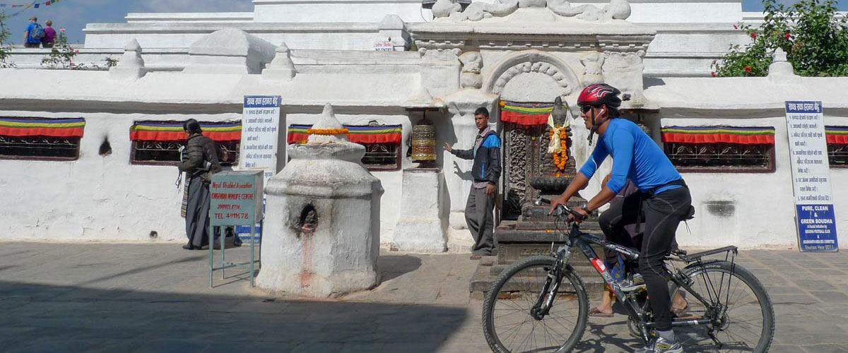
Leh Historic Cycle Tour | Shanti Stupa, Gonpa Village & Monastery & Leh Fort (20-25 km) 🚲
Our favorite short Leh cycle tour starts at Shaynam Hotel, cycling along willow-lined lanes up to the Japanese-built Shanti Stupa for views over the green fields and white-washed Ladakhi houses of the villages surrounding Leh. We continue with a bit of off-road cycling to traditional Gompa village and its monastery at the top of the village, dropping and ascending to cycle along the spectacular, high road to Leh Fort, precariously perched, and the monastery complex above Leh Palace. Last a long descent back to Leh via the old city and the Muslim sections of Leh, an incredibly scenic bike trip.
Indus Valley Eastern Monasteries Cycle Tour | Spikuk, Stakna, Thiksey & Shey (45-65km) 🚲
A beautiful Ladakhi day heading out on a bike tour of the eastern Indus Valley monasteries, beginning with 7½ km out of Leh straight down to Spituk Gompa. Stop to visit this 1000 year old Gelugpa (once Nyingmapa) Tibetan Buddhist monastery, named the ‘exemplary monastery’ by the Great Translator Lotsewa Rinchen Zangpo and presently housing about 1000 monks. Back in the jeeps, head past a row of mani stones and chortens along a small willow and popular lined road through the small hamlet of Spituk and cross a small bridge spanning the Indus River. Taking a lovely, rural road with few vehicles, drive along the south of the Indus for about 10 km, reaching the equally small intersecting road coming from Tibetan Choglamsar.
We continue to cycle along this small country road, biking past traditional Buddhist villages, Islamic mosques, whitewashed chortens and fields of barley and peas. About 15 km into the ride the impressive sight of Stakna Gompa looms to our left, and we cycle towards the Indus, climbing for a kilometer to reach this impressively set monastery, founded in the 16th century by a Bhutanese lama, and every year Stakna Hosta a monastic festival that still draws a large contingent of monks from Bhutan!
Cruising back down the hill, we cross the Indus again and cycle another 6 km to Thikey Gompa, a bustling monastic institute and a 12-story Gelugpa complex with a renown Maitreya Buddha in the main assembly hall, an ancient library and incredible murals, artifacts and statues. The monastery was built in the 15th century following instructions of Je Tsongkhapa, and has one of the largest monastic schools in Ladakh.
From Thiksey (or Shey) we have options to cycle the last 15 kilometers uphill back to the Shaynam Hotel, or to throw the bikes onto the jeep and drive back with Ang Chuk. From Thiksey to Shey, we cycle west on a flat road along the main highway, paved but with few cars, for 5 km to reach ancient Shey Gompa, one of Ladakh’s old capitals, now in ruins except for the monastery. Cycling further west on the same road, we soon reach the back intersection to Leh, avoiding busy Choglamsar, and climb for about 10 km to the very busy main road. The last 3 or so km are on the main road, crossing through an equally busy intersection at the petrol pump, with the last steep 1 km on our small Old Leh Rd to Shaynam. A big cycling day for our third day at altitude in the Indian Himalaya!
Spitok Gonpa & Stok Palace Cycle Tour (35+km) 🚲
Another great option for cycling tours out of Leh begins with the 7 km downhill to Spitok Gompa, followed by a bucolic cycle across the other side of the Indus, and finally a steep 7 km cycle up to Stok Palace and leafy Stok village. The Ladakh royal family still resides part of the year in this palace, which houses a wonderful prayer room and a very interesting museum, worth a visit (and perhaps an overnight stay). The road continues 2 or 3 km past the palace, ending where the trek to Stok La begins at the top of the valley. Cruise back down the 9-10 km paved road, cross the Indus at Choglamsar, and cycle up the back road to reach Shaynam Hotel.
EAST | Shey, Thikse, Hemis, Chemde (Chemre), Thagthok (Sakti), Stakna & Matho Gompas. Stok Palace has wonderful heritage rooms and chalets for overnight stays, and Sakti has charming homestays.
WEST | Spitok, Phyang, Basgo, Likir, Alchi, Rizdong & Lamayuru Gompas. Alchi is a wonderful village to spend the night, and ditto for Lamayuru, which also has several hotels near this picturesque monastery.
Indus or Zanskar White Water Rafting 🚣♀️🚣
Exciting white-water rafting trips on the Indus (less challenging) or Zanskar Rivers, $40 – $50.
LEH SIGHTSEEING & CYCLING NOTE | Because of the altitude of Leh, you may opt to ONLY do some jeep sightseeing through the Indus Valley, or to wander through Leh’s endlessly fascinating old town or relax and make sure your bike is tuned up. We will discuss options in Leh!
Day 4 – Bike Kaya 3327m (Ladakh) (72 km)
Our cycling journey begins just after breakfast, the start of an epic bicycle trip through much of the western Indian Himalaya! Leaving Shaynam Hotel, we cycle across to the highway, and descend for about 7 km to Spitok Gompa, spectacularly perched on a craggy hillock above the cultivated fields of Spitok village. Heading to the right, still on the highway, we continue to bike on a flatter section of road, bike past a check post, several chains of dhabas (small Indian tea and food restaurants), and pass the green oasis of Phyang Gompa and Phyang village to our right. We have a long hill to climb, though not a particularly steep one, and finally descend to reach ‘Magnetic Hill’.
We continue along the undulating, often cliff-side road past the intersection of the Indus and Zanskar Rivers, always different hues of greens and browns, with rafting companies set up below. The Zanskar River once the Zanskar villagers’ lifeline during the harsh winters, and the start (or ending) of the winter Chadar frozen river trek. Stop for a look back at the spectacular panorama of the Ladakh range, which extends westward to meet the Karakorum range in the distance. We turn sharply left at the next intersection, marked by a large sign over the highway, descend to the riverside and follow the Zanskar River for about 20 scenic km to reach Chilling, and just afterwards the new bridge connecting Ladakh with the Markha Valley region. (65 km)
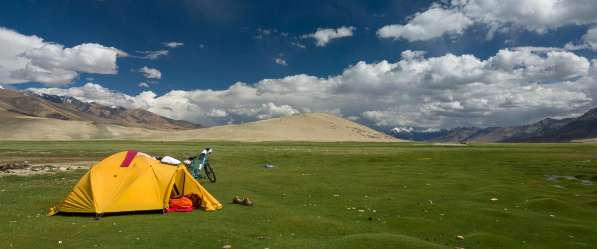
We have a switch backing climb for 3 km to reach the high point of Kaya La (3325m), marked with Tibetan Buddhist prayer flags, before descending for about another 3 km into the beautiful, cultural Markha valley. Our first campsite of the trip is set up in a small, green field next to a local ‘homestay’, more of a local house these days. Once at camp, we’ll introduce you to our Kamzang Journeys campsite, get you set up in your own 3-person dome tent, and start the afternoon with a mug of masala chai, or perhaps a chilled beer from a nearby teahouse.
Later in the afternoon, if you have a bit of extra energy to spare, get back on the bike and cycle past Kaya Gompa to the right, with the ruins of an ancient monastery above to the left. Continue on a flat, unpaved (in 2025) road for about 2 km to reach Skyu (3350m), a small hamlet of two house, marked by a cluster of impressive white-washed chortens and a long mani wall, with the thousand year old Skyu Gompa just to the back to your left, perched on a small rock outcropping. The trail to the left of the monastery leads to Shingo village and the Ganda La pass (4985m), crossing the Zanskar Range. And the other side of this river valley, look for the ruins of what locals have told us were four ancient monasteries, or perhaps buildings of one massive one. About half of Skyu village and many of the ancient chortens along the trail up to Shingo were buried in mud and debris after the devastating mudslides and floods of 2010. (B, L, D)
Distance: 72 km
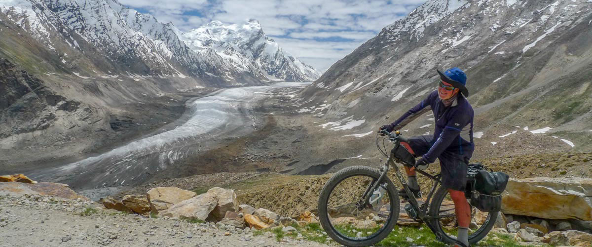
Day 5 – Bike Nyeraks Sumdo & Nyeraks 3677m (Zanskar) (63 km)
Leaving Kaya, we cycle back to the Kaya La, down the switchbacks, perhaps taking the shorter, unpaved route just before reaching the small pass, re-cross the bridge and reach the Chilling road again. We turn left, and spend the day cycling along this spectacular gorge road, sometimes hugging cliff sides, other times down closer to the river, always undulating. In 2025, the road was under construction, only about half paved, and opened for vehicles for 1½ days each week. This road follows the Chadar frozen river ‘trek’ (or route, for locals) mentioned above; you can watch many poignant documentaries on this now well-known route, which children and their parents used to get to and from school in the winter, when the passes were covered in snow, making the roads between Zanskar and Leh impassible.
A few hours into our hot cycle, we’ll spot an impressive waterfall, or more properly a water spout, protruding from a contorted cliffside across the river. Much of this landscape has been shaped by millennium old contortions, its sedimentary cliff walls thrust up, and twisted into fantastic shapes. Sometime mid-day, we’ll cross a bridge (there was once a small, wooden foot bridge precariously built high above the Zanskar River, without guard rails, terrifying) and climb for a very short time to reach Nyeraks Sumdo, a collection of a few teashops, where we will enjoy a long break over lunch and tea.
From Nyeraks Sumdo, we can opt to either cycle or drive the 400 meters (11 km) up to our next campsite at Nyeraks village. Nyeraks, perched on a plateau high above the Zanskar, was once a far-flung ethnically Tibetan village, but is now connected by road to the rest of Ladakh & Zanskar. In Nyeraks, we begin to understand the harshness of life in such a setting, between pass and river gorge, a seemingly impossible place, with its own beautiful monastery, and even an old, sacred tree. The small Nyeraks Gompa is wonderful, a real relic of times past which is white-washed yearly, a colorful event. The gompa was being renovated and repainted in 2015 by monks and painters from Lingshed, with which it is associated. We once saw the procession of the Ngari Rimpoche, who is the younger brother of the Dalai Lama, leaving Nyeraks after a visit to the monastery, an elaborate procession with parasols, musicians, horses and locals following.
Our campsite is another spectacular one on this remote Ladakh trek, with incredible sunset views over the village, passes and craggy peaks. The quality of light in this part of the Himalaya is breathtaking; be sure to have an evening stroll through the village and take it all in. The alfalfa fields are fodder for the animals for the rest of the year, and we often see striped, tufted hoopoes flitting from willow to willow. The other trees are possibly Nepal alders, though we are still in the process of identifying them. We also find these same trees in Mustang!
Sonam Yanskit’s daughter, Thinle Angmo, lives in Nyeraks with her husband and four young children, the youngest 5 (2020). Angmo is an ‘amchi’, or Tibetan doctor, having completed several years of study at Lingshed Gompa years ago, and she now treats local villagers for trade or a small donation. Her husband is often away, working at a medical center in Kaltze, a world away from Nyeraks, and her adorable 1 year old (in 2022) daughter Tashi took her first steps last year when we visited! A large house at the top of the village, once the house of a village chief, has an exquisite house gonpa that we may be able to visit; their cute, young sons love to play in the courtyard. Most of the houses are of traditional Ladakhi design, with an open courtyard in the center of the first floor of the house, where most work is done, and time spent in the sun.
Distance: 63 km
Day 6 – Bike Zangla River Camp 3435m (43 km)
After a scenic breakfast, saying goodbye to our Nyeraks friends, we descend the 11 km back to Nyeraks Sumdo, turn left, and continue to cycle along the Zanskar River. Staying on the same side of the river for the next hour or so, the road is again undulating, passing through impressive half-tunnels blasted into the rock faces, the landscape as dramatic as yesterday. We cross and recross the Zanskar, the road being constructed in 2025, so challenging dusty and hot cycling. The landscape becomes greener after a climb past the flying fox at the intersection of the Zingchen River, and continues to brighten as we cycle towards central Zanskar. High above the valley below, we’ll spot Pidmo village to our right, and continue to climb gradually, contouring around a couple of small valleys. And finally, we’re treated to the fabulously beautiful sight of central Zanskar and the green Zangla village ahead, with Stongde peak as a backdrop.
We’ll enjoy the paved descent, passing the semi-nomadic doksa at Honya Doksa. Doksa means seasonal nomadic settlement in Ladakhi, and the locals from Honya Doksa will pass by our nearby campsite in the evenings with their large herds of sheep, goats and donkeys, making for some classic photos of traditional life in Zanskar. The deep gorge, through which we ascend over 1000 meters to reach the Namkha La and our ‘Bear Valley ‘trekking route, opens dramatically to our left just to the top end of the doksa.
Continuing to cycle along the paved, relatively flat road, we look ahead down the Zangla River valley, toward the incredibly dramatic vista ahead: Zangla Ani Gonpa (nunnery) at the bottom (left) of Zangla, the traditional village of Zangla, and then the many whitewashed chortens leading up to the iconic Zangla Fort perched on top of a ridge to the far right of the village. About 5 km past Honya Doksa, we take a short, hidden right and cycle over the plateau to reach our beautiful Zangla River Camp, with a chance to wash up after a dusty day in the spring just next to our grassy campsite. Sunsets and sunrises over the iconic Zangla Fortress are amazing from camp, the perfect end to a classic Zanskar cycling day! (B, L, D)
Distance: 43 km
Day 7 – Bike Stongde, Padum & Mune 3800m (Zanskar) | Optional Bike Stongde Gompa 3810m (54 km)
A wonderful Central Zanskar cycling day, with a chance to explore some of the ancient monasteries of Central Zanskar en route. Leaving Zangla River Camp, we cycle back overland to the main road, descend through the entrance flag, and soon pass a local Zanskar lhatoo to the left of the road, a shrine to the mountain deity that lives on the peak near the fortress. Cycling south for 19 km along a relatively flat road, we bike past the hamlet of Tsazar, with Rinam across the Zanskar River, to reach Stonge village, with the fabulous Stongde Monastery high above. The iconic Karsha Gompa and Nunnery is visible across the Zanskar River, a sprawling, important monastery built high into the hillside, above Karsha village.
OPTIONAL STONGDE GOMPA SIDETRIP
Just before reaching the main village, we can opt to bike steeply up the many steep switchback to Stongde Gompa, and back down again.
Distance: 5.4 km (r/t)
Stongde Gompa 3815m
Stongde Gonpa, one of the oldest in Zanskar, was built in 1052 by Naropa’s disciple, the famous translator Lama Marpa, and taken over by the Gelugpa in the 15th century, with Je Tsongkhapa as its present head. Stongde is the second largest monastery in Zanskar, with approximately 60 monks and many students, renowned for its Gustor Festival during the summer. Climb to the monastery roof for wonderful views of the patchwork of Stongde village and the Zanskar valley. It’s one of the most lively and colorful monasteries, perched precariously up on a craggy rock ledge, and surrounded by lovely birch woods. We has many friends there, including Geshe Lobsang who lectures and travels around the world, and founded the monastic school. Geshe Stenzin and his brother, are also good friends; they might invite us for tea and give us a tour of the gompa, including its room of treasures in back of the oldest ‘lhakhang’, or prayer hall. We might be able to catch the evening puja in the butter-lamp lit prayer room, a surreal experience with resonating, deep chanting, cymbals, Tibetan drums, a step back hundreds of years …
We continue to bike on the well-paved, generally flat road, crossing the (now) Kargiak River, and passing Pipiting Gompa which we can see as we approach, to reach Padum (3585m), a town with a Central Asian flair and a large Muslim population (including several mosques), a transit point for goods coming and going from Leh to Kargil. Padum is the administrative center of the Zanskar, named after the Buddhist guru Padmasambhava. Historically, it was one of the two main capitals of the Zanskar Kingdom, the other being Zangla. The Zanskar River flows through the valley from its source at the Drang Drung glacier of the Pensi La, and joins the Lungnak River near Pibiting.
We’ll cycle through town, perhaps stopping for a few plates of momos from our friend Phuntsok’s Lhasa Restaurant. Just before leaving town, take a left to visit the incredible, thousand-year-old pre- Buddhist Gyalba Rigsinga (five Buddha) rock carvings just below the police station. In 2025, because of a massive rock that had slipped down onto the road, and the planned dynamiting at 4 pm, we turned around for 5 minutes, cycled down to the river, and camped in lovely Shilla at our Shilla Camp (3600m) in the yard of a local family.
Turning right, we cycle south along the main Zanskar (paved) road, biking towards Barden Monastery, with the villages Shilla and Pipcha are to the opposite side of the river as the main trail, on a jeep road that might be great cycling soon. About an hour away, at the massive Barden Gonpa, we can stop for to visit the assembly halls, with its ancient murals, the men perhaps given a chance to visit the gonkhong, or protector deities’ room.
Back on the road leading south into Zanskar, we continue to cycle along the Kargiak River, with a last bit of uphill biking to reach Mune Gompa and Mune, the ‘twin village’ to Raru, the later village home to a large, European-sponsored school. In 2025, we were fortunate to arrive at Mune Gompa (3810m) for the opening ceremony of a Guru Rimpoche statue, the monks chanting and beating drums and cymbals, and local men playing their Central Asian drums. Our campsite is set up somewhere in Mune, and we’ll have the afternoon to explore … (B, L, D)
Distance: 54 km
Bardan Monastery
Bardan Monastery is a Drukpa Kagyu monastery dating to around the 16th –17th century, located about 12 km south of Padum in the Zanskar region of Ladakh, perched dramatically on a rocky outcrop above the Lungnak Tsarap river that rises almost vertically from the river, giving it a fortress‑like appearance and commanding views over the valley. It was among the earliest monasteries of the Drukpa (Drugpa) order established in Zanskar and went on to become an important religious center for the valley. The monastery is linked to Drukpa Kagyu masters, with local tradition attributing its establishment to figures such as Deba Gyatso or other disciples within the Drukpa lineage who brought this school firmly into Zanskar.
The Drukpa Kagyu (Drugpa) lineage of Tibetan Buddhism is a branch of the broader Kagyu school known for emphasizing meditative practice and guru–disciple transmission. Within Zanskar, Bardan came to hold a prominent position among Drukpa monasteries and exerted influence over several smaller religious centers and hermitages. From early on, Bardan was recognized as one of the first Drukpa houses in the region, giving it a pioneering status among Zanskar monasteries that followed the same tradition. Over time it became associated with notable lamas such as Lama Barapa, whose seat at Bardan further enhanced the gompa’s standing in the wider Ladakh–Zanskar religious landscape. The monastery is connected historically with other institutions in the valley, including Sani Monastery, which has been described as falling under Bardan’s ecclesiastical authority in certain periods. Monks from Bardan take part in major annual rituals and masked dance festivals (cham), including ceremonies at Sani where the unveiling of sacred images is a key event. The core of the complex is a large dukhang or assembly hall, which houses impressive statues of Buddhist deities and several small stupas made from materials such as clay, bronze, wood, and copper. Though smaller than some other Zanskar gompas like Karsha, Bardan preserves valuable religious art in the form of images, thangkas, and sculpted stupas that reflect the Drukpa aesthetic of the period. Its compact scale and dramatic siting give it a distinctive character compared with the more sprawling monastic complexes elsewhere in Ladakh. Bardan functions as a community monastery for monks from surrounding villages, supporting daily rituals, prayers for local households, and religious education. Its calendar includes festivals where monks perform masked dances, echoing the ritual drama of other Ladakhi monasteries but in a more intimate Zanskar setting. Through its links with satellite monasteries and hermitages, Bardan helped knit together religious life along the Lungnak valley, especially on the route leading toward Phuktal Monastery further up the river. The gompa thus serves both as a spiritual centre for locals and a historical waypoint for pilgrims and travelers exploring the Ladakh–Zanskar Buddhist heritage.” – AI
Mons
“Mons of the Khesa race were dominant in the past in the region of western Himalayas. The Mons have been Buddhist in the region from the time of the Kushan dynasty, established by Emperor Kanishka. Mons, the dominant population in the Zanskar valley, and are said to belong to an Aryan race linked to Kaniskha’s period as their features do not match those of the local tribes or the Mongolians. Mons are credited with building 30 monasteries, chortens and temples, including Karsha Monastery in the main Zanskar valley; some of the other monasteries they built are: Teta, Muni, Phuktal, Pune, Bardol, Togrimo, Padum, Pipting, Tondhe, Zangla, Linshot and Sumda. Gelugpa monastery is another important monastery in Khursha village, which has an excellent display of mural arts. – Wikipedia
Day 8 – Bike Tangze 3978m (Zanskar) (44.7 km)
We cycle along the wonderful, paved jeep road into Zanskar, the Lungnak Valley, following the Kargiak, and cross the bridge to just below lovely Ichar. We continue to cycle through incredibly idyllic Zanskar landscapes, passing traditional hamlets, billowing barley fields, whitewashed chortens, and ancient Buddhist mani walls. This section of road was under construction in 2025, but should be paved by the time you are cycling it. We cross another bridge and cycle along a great, paved road (the old trekking route), stopping for a lunch with views at small dhaba. After lunch, we continue on a spectacular section of road, ascending on switchbacks to a high point of 3360m, looking down at textured potato, pea and barley fields, Purne and the Tsarap Chu, or ‘dark river, which intersects the Kargiak Chu from the Purne and Phuktal valley. Staying high, the road is narrow, the turns sharp, and the guard rails are intermittent, so cycle carefully and enjoy the ride!
Passing the small village of Yal, where fodder and kindling dry on the rooftops and continue on our high trail overlooking the Kargyak Chu until we reach the labyrinthine village of Testa, an oasis of green fields and traditional Zanskari houses. Next comes the colorful Kuru with its many threshing circles and white-washed mani walls. Cycling further along the trail past Kuru’s long chain of mani walls, we descend crossing a small stream coming down from our right, and then continue along the river bank for another half an hour. We cross the Kargiak Chu on a large bridge, continuing for another hour or so to the village of Tangze (4015m), with its many-hued patchwork of fields.
We crest the Purne La (3915m), cycle on to the equally picturesque village of Kuru (3980m), with its threshing fields, soon afterwards crossing the Kargiak River, and continue to cycle past a wonderful cluster of whitewashed chortens and ancient mani walls to our Tangze campsite. Tangze, with its many-hued patchwork of barley and pea fields, and plethora of birds, is one of the largest and most interesting villages in Zanskar, though recently marred by roadwork. We’ll head across the road to the small the small teahouse, owned by our friend Sonam Dorje and run by his daughters, for a cup of chai at some point in the afternoon. Above the village is Tangze Gompa, one of the oldest in Zanskar, backed by jagged, dun-colored peaks. (B, L, D)
Distance: 44.7 km
Day 9 – Bike Bike Kargiak & Lakhang Valley Camp 4480m (Zanskar) | Half Rest Day (24.4 km)
Leaving Tangze, we’ll enjoy the scenic ride to Kargiak (4090m), the first southern village in Zanskar. The green oasis of Kargiak has a solar-powered Sun School, built and sponsored by a Czechoslovakian INGO, an old village monastery up top, large, tricolored chortens to the south of the village and several sprawling multi-family houses forming the center of this scenic village. Our first Kamzang Kid, Singge, comes from this village, and we’ll hope to meet his blind mother who still moves to the doksas to take care of the animals in the summertime.
Leaving Kargiak and its whitewashed chortens, now partially obscured by the roadwork, we cycle on the newly improved (not paved and quite rough in 2023) road, going slightly uphill as we bike towards the iconic Gompa Rangjung, a sacred peak (55 or 5320m CHECK). Staying on the left side of the Kargiak Chu as we bike, we soon a cluster of teahouses and tented camps called Gonpa Rangjung. We used to have some shallow river crossings, but the road is now paved the entire way, and we ascend on a few switchbacks to a high point of 4430m. We descend, turn the corner to the left, and spot our wonderful, grassy campsite right on the silty Kargiak Chu. It’s easy to ignore the roadworkers tents and focus on the edelweiss, grazing horses and whistling marmots, and enjoy our ‘rest afternoon’ at Lakhang. It’s always a chilly night in Lakhang Sumdo after having cycled through balmy Zanskar! (B, L,D)
Distance:24.4 km
Day 10 – Bike Palamo & Jispa Camp 3270m (Lahaul) | Cross Shingo La 5035m (57 km)
Shingo La pass day! Make sure you have plenty of warm clothes, rain gear and a down jacket packed in the support jeep for the ascent of the Shingo La, crossing the Himalayan range. We’ll be more acclimatized for our 10.7 km cycle up the switchbacks of the Shingo La (also called the Shinku La) pass, the border of Zanskar and the Lahaul region of Himachal Pradesh. The switchbacks are now an ‘all-weather’ asphalt route (except for the last 2 km in 2025) on the other side of the glaciated pass which connects Ladakh with HP, thanks to the work of the Border Roads Organization (BRO), a branch of roadbuilders contracted by the Indian Army. We’ll also pass the entrance to the in-progress new tunnel, being built by thousands of Nepali roadworkers. The ascent should take us around 2 – 2½ hours, and we’ll probably share the road with semi-wild yaks.
‘Ki ki so so, lha gyalo’ (may the Gods be victorious)! Once we’ve enjoyed the views down the valley into Himachal Pradesh, over the once frozen and snow-covered lake, we have a wonderful, winding 20 km descent on paved road to Zanskar Sumdo (3920m), a grassy green intersection of two rivers (sumdo) where trekkers traditionally stopped en route up the Shingo La pass from Darcha but is now an Indian Army camp. We continue to cruise downhill, the road barriers generally smashed from falling rocks, to Palamo (3555m), a small, green hamlet where we can stop for lunch next to a small stream, just above an interesting Hindu shrine decorated with colorful pieces of cloth and ibex horns.
Descending, and then ascending slightly, along the switchbacking road for about 10 km, we reach the check post at Darcha, followed by the dhabas and a few houses of Dharcha proper, and finally the Leh-Manali highway. We turn right, following the Bhaga River, and cycle for about 5 km, the landscape heartbreakingly beautiful, saturated with vivid shades of green, if not raining, to the charming mountain village of Jispa, where we camp at a lovely, green campsite by an icy-cold stream. Just past our campsite, Jispa is more of a sprawl of hotels, tented ‘luxury’ camps, and a range of other accommodations, dhabas and restaurants, but our end of Jispa is still quite untouched, though we’ll probably enjoy some Bollywood music from the tented camp next door in the evening. (B, L, D)
Distance: 57 km
Day 11 – Bike Keylong, Sissu & Atal Tunnel. Bike or Drive Gramphoo Food Truck Camp 3320m (Lahaul) (71 km)
After a lovely breakfast on the grass in Jispa, we have a roller-coaster of a ride today and incredibly scenic with typically Himachali hill and village scenery throughout the day. Himachal Pradesh, south of the Himalayan range, has a subalpine – alpine climate, with frigid, snowy winters and cool summers due to the cloud cover and consistent rainfall, and is (again) sublimely beautiful when the sun is out, and the skies are blue.
Leaving Jispa, we cycle up switchbacks, and continue to stay high on a cliff-hugging road (with barriers for just over 50% of the road), descending slightly past the army post of Stingri. We reach Keylong (3080m), the administrative center of Lahaul & Spiti, after cycling 22 km. Keylong is built along the banks of the Bhaga River, just northeast of where the Chenab Valley splits into the Chandra and Bhaga valleys. The Drukpa Kardang Monastery, the largest and most important monastery in Lahaul, as well as Shasur and Tayul Monasteries, are all nearby, and the annual ‘Lahaul Festival’ is held in Keylong each July, with a bustling market and cultural activities.
Our hilly ride continues as we cycle 28 km further, passing breathtakingly stunning valleys ending in white glaciers, with waterfalls plummeting down impressive rock faces to the green valleys below. We may pass local beekeepers, a chance to pick up some local honey from bees that are transported to Haryana at the end of the summer. Finally, a bit of downhill cruising to reach the hotels and restaurants of Sissu, which we bypass to get to our favorite dhaba (traditional local blood sausages on offer) at the end of Sissu (3035m), on the banks of the raging river.
After lunch, we’re headed for Khoksar, the Atal Tunnel and Gramphoo. Once at the Atal Tunnel, a flat 4-5 km, we can opt to drive or ride the last 12 challenging (but beautiful) km past the check post at Khoksar, up the 300 meters of switchbacks, the start of the Rotang Pass, to our quirky and wonderful water campsite which we’ve named Gramphoo Food Truck Camp, where we’ll watch the shepherds herd their large flocks of sheep and goats down to their villages in the late afternoon. (B, L, D)
Distance: 60 km + 11 km
Kardang Monastery 3500m
The Drukpa Kardang Gompa is the most important monastery in the Lahaul valley, situated on the left bank of the Bhaga River, facing Keylong. The monastery was contructed around the 12th century, and is home to both nuns and monks. Interestingly, the monks and nuns enjoy equal rights, and the monks are allowed to marry.
See ‘Indus Valley, Ladakh & Zanskar, & Himachal Pradesh Historic Monasteries, Fortresses & Palaces’ document for more information
Day 12 – Bike Chhatru & Batal 4,060m (Lahaul) (48 km)
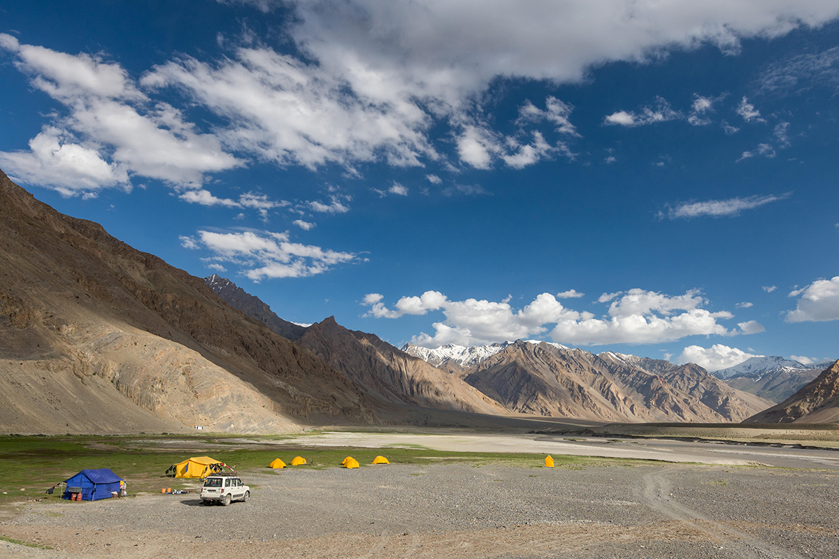
Leaving camp at Gramphoo, having enjoyed a stream-side breakfast (next to the food trucks), we cycle past the turnoff to the Rotang La, take a left on the unpaved Highway 505, and descend a few switchbacks to the Chandra River, ascending again, with an undulating but relatively flat ride to a beautiful cluster of chortens and prayer flags across from a small teahouse (4000m).
We continue on the unpaved road, still following the Chandra River, with many small water crossings throughout the day. We cycle a total of 17.5 unpaved km, cross the bridge, and reach the colorful teahouses of Chhatru (3330m), where we’ll stop for a chai and snack. We continue to cycle along the Spiti Highway, which is in turn quite easy to quite challenging, always following the Spiti River, through fabulous landscapes of weathered and rough rocks, hanging glaciers, scree slopes, and rock-slide areas peppered with grassy riverside sections. We have one last dramatic high(ish) ride, soon descending to a rougher road (our roughest section of the day), with water running along the rutted road, to reach Badal (Kunzum La Base Camp), a lovely, green campsite with sedimentary red rocks jutting up through the meadows, situated a short distance below tomorrow’s 4540m pass crossing. (B, L, D)
Distance: 48 km
Day 13 – Bike Losar 4095m (Spiti) | Cross Kunzum La 4540m (32 km)
We’ll appreciate our freshly brewed coffee this morning as we psyche ourselves up for the crossing of the Kunzum La pass, a relatively challenging ride of 11.5 km that should take us a bit more than 2 hours. The switchbacks are gradual, with dramatic views over the wide riverbed and valley below, and soon the old switchbacks visible ahead, across the small tributary stream. After reaching the prayer flag festooned top, a separate loop, we descend an hour on an unpaved (2025) road to Taksay (4130m), the Key Gompa Trulku’s picnic spot and a great spot for lunch or a snack (22.5 km from Batal). From this beautiful spot, we continue downhill gradually for a few kilometers to reach the Spiti valley, cycling past yaks grazing in the green valley. Turning right, we cycle about 3 km to reach Losar, the first village of the Spiti valley, bright with blue wild geraniums, barley fields turning golden, and green fields of peas for which Spiti is famous. Above is Losar Gompa, which affords wonderful views over the four villages of Losar. Losar, and all of the villages of Spiti, have Tibetan-style buildings, speak nearly pure Tibetan, and have a more Tibetan culture in general due to their proximity to Tibet and historical trade with Tibet for a millennium. Spiti was in fact part of western Tibet at various points in history, but always had its own king. We’ll camp at the government rest stop, or perhaps elsewhere in this interesting village if we find a free plot of land, enjoying the redstarts flitting around camp. (B, L, D)
Distance: 32 km
Day 14 – Bike Chicham & Kibber 4106m (Spiti) (41 km)
Leaving Losar, we have a spectacular cycling day, soon reaching the hamlet of Hanse 3955m (12.5 km), a small village with good camping, the road shaded by willows, and colored by billowing barley fields. Continuing, we cycle 3.5 km further to Kiato (3950m), another good camping spot. We begin to climb through a magical valley of hoodoos, high on a cliff-hugging road over a canyon, with vast views of the Spiti Valley throughout. We climb to the prayer flags of the Dumle La (4210m), almost 29 km from Losar.
Descending, we pass the old Ladarcha fairgrounds as we head to Chicham. The Ladarcha fair, revived by the HP government in the 1980s and now held in Kaza, is the largest annual event in Spiti, which, in earlier times, was an annual trade fair held at the Ladarcha grounds just after the pass. Traders came from as far as Spiti, Ladakh, Bushahr princely state, Kullu and Tibet, but ended following the Sino-Indian war of 1962.
Descending very gradually, we reach the Chicham viewpoint (4130m), and can make a short visit to Chicham before descending slightly to cross the famous Chicham Bridge, over 300m above the gorge. We have about 3 hot km of gradual switch backing to reach the incredibly scenic village of Kibber, the first (or last) village of Spiti, a Tibetan speaking village with Tibetan architecture, especially visible in the windows. Kibber, a stop on the Ladakh – Tibet trade routes, is built right on a limestone cliff, a semi-circular village with the monastery on top of town. The Kibber Wildlife Sanctuary is home to about 30 snow leopards, and the starting or ending point for treks to Lake Tsomoriri, crossing the Zanskar range via the Parang La pass (5580m).
“One of the earliest descriptions is by botanist Thomson based on his expedition in September 1847. The route descends along the Pare Chu (river) after crossing the Parang La, to reach Hanle and the Indus. Thomson observed that houses in Kibber were constructed of stone, unlike the mud construction used in the rest of Spiti. In earlier times, annual trade fairs were held in Kibber and other locations in Spiti. Traders would come from Tibet, Ladakh, Chamba and Kullu to barter their wares. The terrain slopes gently upwards from Kibber towards the northeast until the towering Zanskar Range, and the streams in the area have cut deep gorges in the limestone strata. Mountain ranges on all sides provide some protection, and water from the streams is useful for irrigation.” – Wikipedia
Distance: 41 km
Day 15 – Bike Kye Gompa, Kaza & Lhalung Gompa 3,725m (Spiti) (45 km)
Leaving camp at Kibber, we have a fabulous descent on a great road, with views up and down the valley throughout, stopping just after leaving Kibber for beautiful views back to the village. After about 5 km, we make a detour of about 1-2 km from the switch backing downhill, cycling up slightly to the fabulously-set and fascinating Kye Gompa (3150m) (voted ‘Most Livable Monastery of 2025’). We return via the lovely Kye village, from where we’re treated to spectacular views of the gompa above (we took photos from Samskit Homestay in 2025).
Kye (Kyi, Kye, Ki, Kee) Gompa 4160m
“The Gelugpa Kye Gompa is located high above the Spiti River, the largest monastery of the Spiti Valley and a religious training center for lamas. It reportedly had 100 monks in 1855, and is dedicated to Lochen Tulku, the 24th reincarnation of the great translator Lotsawa Rinchen Zangpo. Kye Gompa is said to have been founded by Dromtön (1008–1064 CE), a pupil of the famous teacher, Atisha, in the 11th century. This may, however, refer to a now destroyed Kadampa Monastery at the nearby village of Rangrik (across the river), which was probably destroyed in the 14th century when the Sakya sect rose to power with Mongol assistance. In the mid-17th century, during the reign of the 5th Dalai Lama, Kye was extensively plundered and damaged by the Mongols, and became a Gelugpa establishment. Around 1821, it was sacked again during the wars between Ladakh and Kulu. In 1841, during the Dogra–Tibetan war, it was severely damaged by the Dogra army under Ghulam Khan and Rahim Khan. Later that same year, it was also attacked by Sikhs. In the 1840s, it was ravaged by fire and, in 1975, a violent earthquake caused further damage which was repaired with the help of the Archaeological Survey of India and the State Public Works Department. The walls of the monastery are covered with paintings and murals, an example of 14th century monastic architecture.
We descend on the same switchbacks to the Spiti River, where we turn right and follow the river on the generally good road, with little traffic, passing the Langza intersection (3750m) which leads up to Langza, a Lepcha village. We’ll take the upper road, passing above busy Kaza (3675m), said to be one of the coldest towns in India, and divided into the old and new administrative sections. (if one approaches Kaza from the south, you might spot Kyu-ling, the palace of the Nono (king) on the other side of the river). Kaza is known for its colorful festivals and the ruins of the ancient Sakya Tangyud Monastery. The new Sakya Tangyud Monastery was built in 2009, and is located just north of Kaza.
Leaving Kaza, we might spot men selling local eggs, just afterwards passing through a small section of hoodoos at Shego village (38km from Kibber), followed by a great shady spot to the right of the road, perfect for a snack and drink spot. Turning right at the Dhankar and Lhalung Gompa road, cycling up a series of many switchbacks (over 400m), and turning left (instead of right to Dankar) to reach Lhalung village and Lhalung Gompa about 14 km from the main road. The monastery is said to rival Alchi and Tabo, though more intimate, and featuring gilded clay sculptures and incredible murals adorning the monastery walls. We’ll set up camp in this peaceful, bucolic village of about 14 households, the largest village in the Lingti valley, and head out to visit the monastery.
Kye Gompa accommodates nearly 250 monks, who reside within the sacred walls throughout the year. Some monks go to South Indian Monasteries during winters, the rest of them stay inside the monastery walls. These monasteries have their regular heads; these heads are the reincarnations of Guru Rinpoche. The current head of Kee Monastery is from Kinnaur district of Himachal Pradesh. He is 19th birth of Guru Rinpoche. A celebration of its millennium was conducted in 2000 in the presence of the Dalai Lama. A new Prayer Hall was inaugurated on 3 August 2000 by the Fourteenth Dalai Lama. It was presented through a tableau in the 69th Republic Day celebration held at Delhi. In recent times the monastery has also hosted the “Kachen Dugyal Memorial Old Aged – Handicapped Society” which provides accommodation for a number of elderly and disabled people.” – Wikipedia
See ‘Indus Valley, Ladakh & Zanskar, & Himachal Pradesh Historic Monasteries, Fortresses & Palaces’ document for more information
Lhalung Gompa
“Lhalung Monastery (also known as the Sarkhang or Golden Temple), was one of the earliest monasteries founded in Spiti, Himachal Pradesh, by the great Tibetan Buddhist lotswa (translator) Richin Zangpo, the king of western Himalayan Kingdom of Guge during the late 10th century. The name Lhalun literally means ‘land of the gods’ and it is said that the Lhalung Devta is head of all the devtras of the valley, and emerges from the Tangmar mountain beyond the village. The mountain is said to change colour depending on the moods of the devtas or deities; red showing anger, yellow, happiness, etc. Remains of an ancient wall encircling all the monastery buildings may be found in places. It is probable that, like Tabo, it was designed as a choshor site, a place for learning and debate as opposed to a simple village monastery or a chapel for worship by the local people. There is also a sacred tree here which may be as old as the earliest monastery.
The monastery was originally a Kadampa establishment, but might have turned into a Sa-kya-pa stronghold in the 14th century. Some of the damaged temples at Lhalung Gompa may be the spoils of that period. In the 17th century, the monastery was annexed to the Gelugpa fold by the Mongols, despite the Sakyapa resistance and, a loss of a few more temples. Thus out of the nine temples of the Lotsaba’s time, only one now remain.” – Wikipedia
Distance: 45 km
Day 16 – Bike Dhankar & Bike Mane Gongma 3565m (Spiti) (27 km)
Back on our bikes, we switchback down to the interection in the road, and head to Dangkar village, fortress and monastery, with spectacular view of the ruins of the ancient fort and monastery perched on a craggy cliff in front as we bike towards it. We enter Dhankar through a break in the semi-circular village, with breathtaking views over the new monastery, the village and the Spiti valley far below.
Dhankar is the old capital of the Spiti region, situated partially on a rock outcropping far above the Spiti River. The ancient Dhankar Gompa is at the top of this precipitous spur, overlooking the confluence of the Spiti and Pin Rivers, one of the world’s most spectacular monastery settings. Dhang or dang means cliff or rock, and kar or khar means fort, so Dhankgar is the fortress build on the rock cliff. Note the stuffed and decorated sheep hanging over the stairs leading to the prayer rooms, a vestige of ancient forms of Buddhist (and Hinduism) where an animal (generally a sheep or goat) is gifted to the monastery, and thus saved from further work (or being slaughtered for meat). There is a new, very large monastery on the other side of the semi-circle, housing the many monks who reside here at Dhankar.
Dhankar, like Key, Tangyud, and Thiksey, Likir and Rangdum monasteries, was built in the fortified Tibetan dzong style. Below the Gompa lies the small village of Shichilling which contains the new Dhankar Monastery, home to about 150 monks belonging to the Gelug school of Tibetan Buddhism. Beyond the surrounding harsh, lunar landscape, notable sights at Dhankar Gompa include a statue of Vairocana consisting of four figures seated back-to-back, in addition to various crumbling thangkas. There is a small museum in the gompa. In 2006, World Monuments Fund selected Dhankar gompa as one of the 100 most endangered sites in the world. A nonprofit group, Dhankar Initiative, is attempting to organize its conservation.
Dhankar was the traditional capital of the Spiti during the 17th century and has some features dating back to the 12th century. It was the seat of the early rulers of Spiti, the Nonos, who had the right to cultivate the government lands nearby and were required to keep the fort in repair. They also dispensed justice to the people and were noted for their harsh penalties until the British replaced them. A new Teaching Temple was inaugurated by the Dalai Lama in 2009.
After a look around Dhankar, we descend for approximately 8 km of switchbacks, we reach the main road and Sichilling village, which has been partially destroyed many times by yearly mudslides. We follow the dramatic, undulating road along the Spiti River, with steep (45%) scree slopes to our left, being careful to not stop often because of potential rock falls. After 8 km, we pass the Mane Yongma intersection and bridge; it’s 6-7 km up to this doksa that we’d like to visit, supposed to be a beautiful setting.
Distance: 27 km
Day 17 – Bike Poh, Tabo Gompa & Gue (Spiti) | Visit Gue Mummy 3607m (59 km)
The road takes a sharp turn to the northeast to reach Poh (21 km from Dhangkar), our friend Tsering Londup’s village, filled with apple and apricot trees (as most village in Spiti are), where we can stop at the shop for a break. We continue to cycle 10 km to ancient Tabo Gompa and village (3175m), where we have the afternoon to visit the renown Tabo Gompa, known as ‘the Ajanta of the Himalayas’. The village of Tabo surrounds Tabo Gompa, reputed to be over a thousand years old. The Dalai Lama has expressed his desire to retire to Tabo, and in1996 conducted the Kalachakra initiation ceremony there, which coincided with the millennium anniversary celebrations of Tabo Gompa.
We pass the check post at Lari after 37.5 km (about 2 km from Tabo), and continue another 15 km to pass Hurling village (3120m), where we can stock up on more ripe apricots falling on the road. After another 20 or so, cycling through dun-colored, contorted rock faces on a small, paved cliff-side road above the river, which becomes more narrow and canyonlike as we progress, we reach the turnoff to our destination, the village of Gue. We have one last big climb, a hot 500-meter switchback, an 8.3 km ascent above the stream below, with a green oasis about 5 km up the hill, but otherwise bordered by rocks and rocky hillsides. Gue is a picturesque village of rugged, textured mountain views only a few km from the border of Tibet (your mobile will pick up the China Mobile network). We’re camped right in the middle of Gue, and after a cold wash, we can head up to visit the mummy and beautiful monastery (3700m) …
Gue Mummy
“High in Himachal Pradesh’s Lahaul & Spiti district lies a surprising secret. A 500-year-old mummy with its teeth intact, it is said to be the mummy of a Buddhist monk named Sangha Tenzin. The mummified body of the monk was found after an earthquake in 1975 opened an old tomb. It was excavated much later in 2004, and has been a point of interest for archaeologists, and curious travelers ever since.
The mummification of this monk is starkly different from those of Egypt. It is said to be the result of a natural self-mummification process called Sokushinbutsu, which strips the body away from its fats and fluids. It is attributed to Buddhist monks in Japan’s Yamagata. The process can take up to ten years. The monks go into slow starvation, with a diet of poisonous nuts, roots, herbs, and tree sap. Seated in a meditating posture, the monks die without any moisture in the body, but having all essentials preserved. The mummy of Sangha Tenzin is seated in a temple today, with his mouth open, his teeth visible, and hollow eyes. Stripped of fat, and moisture, it symbolizes the Living Buddha.” – Times of India (B, L, D)
Tabo Monastery
“Tabo Gompa, home to approximately 45 monks, was founded in 996 by the great translator Lotsawa Rinchen Zangpo, on behalf of the king of western Himalayan Kingdom of Guge, Yeshe-Ö. Tabo was built as a ‘daughter’ monastery of the Tholing Monastery in Ngari, western Tibet, the oldest continuously operating Buddhist enclave in India and the Himalayas. A large number of frescoes displayed on its walls depict tales from the Buddhist pantheon. There are many priceless collections of thankas (scroll paintings), manuscripts, well-preserved statues, frescos and extensive murals which cover almost every wall. The monastery is protected by the Archaeological Survey of India (ASI) as a national historic treasure of India. The original monastery was severely damaged in the 1975 Kinnaur earthquake. Subsequent to its full restoration and the addition of new structures, the 14th Dalai Lama visited the monastery and initiated the Kalachakra in 1983, after the Kalachakra Temple was built.
Tabo evolved as an important center of learning in its early centuries; the Kadampa School developed into the Gelugpa School. The monastery runs the Serkong School, established in 1999, with 274 students from the age of 5 to 14 years, in classes 1–8. Tabo Monastery’s spiritual head is Tsenshap Serkong Rinpoche. The Tibetan monks perform traditional Buddhist and regional songs and dances during festivals throughout the year. The most popular religious festival is the Chakhar Festival, dedicated to the peace and happiness of all. This is held every three years, usually during September or October. On this occasion, religious masked dances, songs and general festivities are the main events.” – Wikipedia
See ‘Indus Valley, Ladakh & Zanskar, & Himachal Pradesh Historic Monasteries, Fortresses & Palaces’ document for more information
Distance: 59 km
Day 18 – Bike Mailling Gompa 3660m(Kinnaur) | Cross Nako La | Visit Nako (44 km)
Another beautiful Indian Himalayan cycling day to our campsite at Mailling Gompa, just before Nako (3625m), the later the largest village in the Hamrang Valley. We begin the day with the 8.3 km descent back to our turnoff, followed by a flater ride of 3 km to Sumdo check post (3060m), after which we have to be careful of ‘shooting stones’ for the next 5 km. 18.3 km after leaving camp, we reach Shalakhar village, from where we follow the undulating road to Chamba (2975m), 23.5 km from Gue. 1½ km later, at 2900m), we see a sign at the intersection saying ‘No Road’ to our right, and we take the left fork to begin our 900-meter climb. Our first stop is about a third of the way up, 4 km and about 300 meters, to the BSNL viewpoint (3185m), covered with colorful Tibetan lung-ta, or prayer flags. Finally, after a grueling and sometimes steep climb but always scenic climb, we reach the ‘Nako La’ (our name), sadly unmarked although 3840m, a 940 meter climb! We descend for about 2 km, and turn left at the lovely Maillig Gompa, our campsite for the night just 1½ km above Nako.
Nako is a scenic and incredibly interesting village with many old alleyways, houses, chortens (including small multiples of three over doorways) and mani walls, on the small Nako Lake (think paddle boats). Next to the lake is a small, sacred temple, inside a rock with the foot print of Padmasambhava. There is a large population of birdlife, and the lake is green, surrounded by willows and poplars. Locals skate on this lake in the winter!
Tourism (mostly Indian) is encroaching on the village, so it’s not quite a charming as it would have been years ago, but it still maintains its character. Chango Gompa is a few km away from Nako Gompa, on the road from Spiti, which contains a (reputedly) 500+ year old prayer wheel over 3m in diameter, and made of yak skin. Nako, spectacularly set, features the backdrop of Reo Purgyal (6816m), part of the Srikhand range, the highest mountain in Himachal Pradesh. Nako Monastery, and many ancient Tibetan Buddhist chortens are spread throughout the village. “One of the earliest descriptions of Nako is by the botanist Thomas Thomson based on his expedition in August 1847. He reported that Nako was smaller than Peo. He and his team were accommodated in apartments in the Buddhist monastery. There was an abundance of water and extensive cultivation, a copse of poplars and willows, but no fruit trees.” – Wikipedia (B, L, D)
Distance: 44 km
Nako Monastery
Nako Monatery is an incredible ancient treasure at the far end of the village, very much worth exploring. “Nako Monastery, dating from the 11th century, is similar in style to Tabo. It is also known as ‘Lotsava Jhakang’ meaning “complex of the translator” named in honor of Rinchen Zangpo who translated Buddhist scriptures from Sanskrit to Tibetan. In the earthquake of 1975 the buildings were affected, and further destroyed during harsh winters. In1998, the University of Vienna launched a research Project in association with the Indian National Trust for Art and Cultural Heritage (INTACH), the Buddhist Association of Nako, and local residents of Nako to carry out restoration works.” – Wikipedia
See ‘Indus Valley, Ladakh & Zanskar, & Himachal Pradesh Historic Monasteries, Fortresses & Palaces’ document for more information.
ALTERNATIVE ROUTE
Day 16 – Bike Kye Gompa, Kaza & Mud (Mudh) River Camp 3710m (Spiti) (71 km)
Leaving camp at Kibber, we have a fabulous descent on a great road, with views up and down the valley throughout, stopping just after leaving Kibber for beautiful views back to the village. After about 5 km, we make a detour of about 1-2 km from the switch backing downhill, cycling up slightly to the fabulously-set and fascinating Kye Gompa (3150m) (voted ‘Most Livable Monastery of 2025’). We return via the lovely Kye village, from where we’re treated to spectacular views of the gompa above (we took photos from Samskit Homestay in 2025). We descend on the same switchbacks to the Spiti River, where we turn right and follow the river on the generally good road, with little traffic, passing the Langza intersection (3750m) which leads up to Langza, a Lepcha village.
We’ll take the upper road, passing above busy Kaza (3675m), said to be one of the coldest towns in India, and divided into the old and new administrative sections. (if one approaches Kaza from the south, you might spot Kyu-ling, the palace of the Nono (king) on the other side of the river). Kaza is known for its colorful festivals and the ruins of the ancient Sakya Tangyud Monastery. The new Sakya Tangyud Monastery was built in 2009, and is located just north of Kaza.
Leaving Kaza, we might spot men selling local eggs, just afterwards passing through a small section of hoodoos at Shego village (38km from Kibber), followed by a great shady spot to the right of the road, perfect for a snack and drink spot. At the bridge over the Spiti river, we being our detour up the scenic Pin Valley, cycling on a newly paved small road past the prayer flag-marked entrance, slightly ascending as we pass many small, attractive hamlets to reach a teahouse on the left at 50 km, at an intersection to the other side of the river. From here, the lovely paved road turned to an unpaved road, with roadwork throughout (not too obtrusive, but bumpy and slower) in 2025. Finally, we see our Mud River Camp about a km before Mud (Mudh), on the grassy riverbanks, near a tented camp. We’ll share the site with Bactrian magpie, and enjoy the craggy peaks surrounding us, and the stratified rocks. (B, L, D)
Distance: 71 km
Kaza Loop (Komik & Kikkim)
The Tangyud Gompa of Komik village, 4 km from Kaza, dates to the early 14th century, built like a fortified castle with massive slanted mud walls and battlements, decorated with vertical red ochre and white stripes, located on the edge of a deep canyon overlooking Kaza. The highest post office in the world at Hikkim village (PIN 172114). at an elevation of 4400m, is situated 46 km (29 mi) from Kaza.
Kye (Kyi, Kye, Ki, Kee) Gompa 4160m
“The Gelugpa Kye Gompa is located high above the Spiti River, the largest monastery of the Spiti Valley and a religious training center for lamas. It reportedly had 100 monks in 1855, and is dedicated to Lochen Tulku, the 24th reincarnation of the great translator Lotsawa Rinchen Zangpo. Kye Gompa is said to have been founded by Dromtön (1008–1064 CE), a pupil of the famous teacher, Atisha, in the 11th century. This may, however, refer to a now destroyed Kadampa Monastery at the nearby village of Rangrik (across the river), which was probably destroyed in the 14th century when the Sakya sect rose to power with Mongol assistance. In the mid-17th century, during the reign of the 5th Dalai Lama, Kye was extensively plundered and damaged by the Mongols, and became a Gelugpa establishment. Around 1821, it was sacked again during the wars between Ladakh and Kulu. In 1841, during the Dogra–Tibetan war, it was severely damaged by the Dogra army under Ghulam Khan and Rahim Khan. Later that same year, it was also attacked by Sikhs. In the 1840s, it was ravaged by fire and, in 1975, a violent earthquake caused further damage which was repaired with the help of the Archaeological Survey of India and the State Public Works Department. The walls of the monastery are covered with paintings and murals, an example of 14th century monastic architecture.
Kye Gompa accommodates nearly 250 monks, who reside within the sacred walls throughout the year. Some monks go to South Indian Monasteries during winters, the rest of them stay inside the monastery walls. These monasteries have their regular heads; these heads are the reincarnations of Guru Rinpoche. The current head of Kee Monastery is from Kinnaur district of Himachal Pradesh. He is 19th birth of Guru Rinpoche. A celebration of its millennium was conducted in 2000 in the presence of the Dalai Lama. A new Prayer Hall was inaugurated on 3 August 2000 by the Fourteenth Dalai Lama. It was presented through a tableau in the 69th Republic Day celebration held at Delhi. In recent times the monastery has also hosted the “Kachen Dugyal Memorial Old Aged – Handicapped Society” which provides accommodation for a number of elderly and disabled people.” – Wikipedia
See ‘Indus Valley, Ladakh & Zanskar, & Himachal Pradesh Historic Monasteries, Fortresses & Palaces’ document for more information
Day 17 – Bike Dhankar 3875m (Spiti) (43.9 km)
After breakfast, we’ll cycle just over 1 km uphill from our river camp to have a look at Mud village (3800m). Returning from Mud, we cycle 13 km downhill to lively Sagnam village (3650m), where we’ll leave the main road for a short cycle exploration of this lovely village and it’s many gardens. Before reaching yesterday’s bridge off the main road, we’ll turn off at the Soshuna junction and visit this local settlement for a bit of cultural touring, and off-road cycling through the damp fields, and over a small wooden bridge (be careful of the seabuckthorne thorns). We reach the main bridge, cross the Spiti River, and then turn sharply right at the Dhankar intersection (3470m) after 35km of cycling, including our look at Mud. We ascend 400 meters, over about 8 km of switchbacks, to reach Dangkar village, fortress and monastery, the spectacular view of the ruins of the ancient fort and monastery perched on a craggy cliff in front as we bike towards it. The last stretch is flatter, and we enter Dhankar through a break in the semi-circular village, with breathtaking views over the new monastery, the village and the Spiti valley far below. Camp is on the far reaches of the village, just before the new monastery.
Dhankar is the old capital of the Spiti region, situated partially on a rock outcropping far above the Spiti River. The ancient Dhankar Gompa is at the top of this precipitous spur, overlooking the confluence of the Spiti and Pin Rivers, one of the world’s most spectacular monastery settings. Dhang or dang means cliff or rock, and kar or khar means fort, so Dhankgar is the fortress build on the rock cliff. Note the stuffed and decorated sheep hanging over the stairs leading to the prayer rooms, a vestige of ancient forms of Buddhist (and Hinduism) where an animal (generally a sheep or goat) is gifted to the monastery, and thus saved from further work (or being slaughtered for meat). There is a new, very large monastery on the other side of the semi-circle, housing the many monks who reside here at Dhankar.
Dhankar, like Key, Tangyud, and Thiksey, Likir and Rangdum monasteries, was built in the fortified Tibetan dzong style. Below the Gompa lies the small village of Shichilling which contains the new Dhankar Monastery, home to about 150 monks belonging to the Gelug school of Tibetan Buddhism. Beyond the surrounding harsh, lunar landscape, notable sights at Dhankar Gompa include a statue of Vairocana consisting of four figures seated back-to-back, in addition to various crumbling thangkas. There is a small museum in the gompa. In 2006, World Monuments Fund selected Dhankar gompa as one of the 100 most endangered sites in the world. A nonprofit group, Dhankar Initiative, is attempting to organize its conservation.
Dhankar was the traditional capital of the Spiti during the 17th century and has some features dating back to the 12th century. It was the seat of the early rulers of Spiti, the Nonos, who had the right to cultivate the government lands nearby and were required to keep the fort in repair. They also dispensed justice to the people and were noted for their harsh penalties until the British replaced them. A new Teaching Temple was inaugurated by the Dalai Lama in 2009.
Distance: 43.9 km
Day 18 – Bike Poh, Tabo & Gue 3610m (Spiti) ()
Descending from Dangkar for approximately 8 km of switchbacks, we reach the main road and Sichilling village, which has been partially destroyed many times by yearly mudslides. We follow the dramatic, undulating road along the Spiti River, with steep (45%) scree slopes to our left, being careful to not stop often because of potential rock falls. After 8 km, we pass the Mane Yongma intersection and bridge; it’s 6-7 km up to this doksa that we’d like to visit, supposed to be a beautiful setting. The road takes a sharp turn to the northeast to reach Poh (21 km from Dhangkar), our friend Tsering Londup’s village, filled with apple and apricot trees (as most village in Spiti are), where we can stop at the shop for a break.
We continue to cycle 10 km to ancient Tabo Gompa and village (3175m), where we have the afternoon to visit the renown Tabo Gompa, known as ‘the Ajanta of the Himalayas’. The village of Tabo surrounds Tabo Gompa, reputed to be over a thousand years old. The Dalai Lama has expressed his desire to retire to Tabo, and in1996 conducted the Kalachakra initiation ceremony there, which coincided with the millennium anniversary celebrations of Tabo Gompa.
We pass the check post at Lari after 37.5 km (about 2 km from Tabo), and continue another 15 km to pass Hurling village (3120m), where we can stock up on more ripe apricots falling on the road. After another 20 or so, cycling through dun-colored, contorted rock faces on a small, paved cliff-side road above the river, which becomes more narrow and canyonlike as we progress, we reach the turnoff to our destination, the village of Gue. We have one last big climb, a hot 500-meter switchback, an 8.3 km ascent above the stream below, with a green oasis about 5 km up the hill, but otherwise bordered by rocks and rocky hillsides. Gue is a picturesque village of rugged, textured mountain views only a few km from the border of Tibet (your mobile will pick up the China Mobile network). We’re camped right in the middle of Gue, and after a cold wash, we can head up to visit the mummy and beautiful monastery (3700m).
Distance:
Gue Mummy
“High in Himachal Pradesh’s Lahaul & Spiti district lies a surprising secret. A 500-year-old mummy with its teeth intact, it is said to be the mummy of a Buddhist monk named Sangha Tenzin. The mummified body of the monk was found after an earthquake in 1975 opened an old tomb. It was excavated much later in 2004, and has been a point of interest for archaeologists, and curious travelers ever since.
The mummification of this monk is starkly different from those of Egypt. It is said to be the result of a natural self-mummification process called Sokushinbutsu, which strips the body away from its fats and fluids. It is attributed to Buddhist monks in Japan’s Yamagata. The process can take up to ten years. The monks go into slow starvation, with a diet of poisonous nuts, roots, herbs, and tree sap. Seated in a meditating posture, the monks die without any moisture in the body, but having all essentials preserved. The mummy of Sangha Tenzin is seated in a temple today, with his mouth open, his teeth visible, and hollow eyes. Stripped of fat, and moisture, it symbolizes the Living Buddha.” – Times of India (B, L, D)
Tabo Monastery
“Tabo Gompa, home to approximately 45 monks, was founded in 996 by the great translator Lotsawa Rinchen Zangpo, on behalf of the king of western Himalayan Kingdom of Guge, Yeshe-Ö. Tabo was built as a ‘daughter’ monastery of the Tholing Monastery in Ngari, western Tibet, the oldest continuously operating Buddhist enclave in India and the Himalayas. A large number of frescoes displayed on its walls depict tales from the Buddhist pantheon. There are many priceless collections of thankas (scroll paintings), manuscripts, well-preserved statues, frescos and extensive murals which cover almost every wall. The monastery is protected by the Archaeological Survey of India (ASI) as a national historic treasure of India. The original monastery was severely damaged in the 1975 Kinnaur earthquake. Subsequent to its full restoration and the addition of new structures, the 14th Dalai Lama visited the monastery and initiated the Kalachakra in 1983, after the Kalachakra Temple was built.
Tabo evolved as an important center of learning in its early centuries; the Kadampa School developed into the Gelugpa School. The monastery runs the Serkong School, established in 1999, with 274 students from the age of 5 to 14 years, in classes 1–8. Tabo Monastery’s spiritual head is Tsenshap Serkong Rinpoche. The Tibetan monks perform traditional Buddhist and regional songs and dances during festivals throughout the year. The most popular religious festival is the Chakhar Festival, dedicated to the peace and happiness of all. This is held every three years, usually during September or October. On this occasion, religious masked dances, songs and general festivities are the main events.” – Wikipedia
See ‘Indus Valley, Ladakh & Zanskar, & Himachal Pradesh Historic Monasteries, Fortresses & Palaces’ document for more information
Day 19 – Bike Pooh (Poo, Spuwa) & Bee Hive Camp 2205m (Kinnaur) (81 km)
OPTION | CYCLE TO DUBLING CAMP
We begin the day with a monster descent, just over 30 km of thrilling switchbacks on a well-paved road (with guard rails, but we’ll have to be wary of rock falls), to meet the Sutlej River which has its source at Mount Kailash, Tibet. We cross at our first Sutlej Bridge (2550m), and continue on a relatively flat road to the Dubling (a village 5 km above the highway) check post (2510m), 35 from camp. We cross the Sutjej just afterwards, and continue cycling on a very slightly undulating road, crossing back to the opposite side after a short distance. The road is smaller after the check post, and becomes a one-lane cliff-side road, sometimes without guard rails, and with potential rock falls throughout the day. In 2025 we had serious headwinds which made it a bit challenging to control the bikes high up above the river, so we’ll cycle carefully on this section, being careful of cars and trucks. There aren’t many vehicles on the roads, relatively, but more than in Spiti.
Late in the morning we’ll reach Pooh (2660m), another stop on the ancient Hindustani – Tibetan trade routes. “Poo, or Pooh, also known as Spuwa is a small town in the Kinnaur district known for its nature, green fields, apricot orchards, vineyards and almond trees. Inscriptions suggest that Poo was an important trading center in the early 11th century. When AH Francke arrived in Poo from the south in 1910, it was the first village he found where the language was “entirely Tibetan”. In Pooh, there is an ancient temple, the Lotsaba Bai Lhakhang, dedicated to Shakyamuni Buddha, and attributed to the translator (or Lotsaba), Rinchen Zangpo (958–1055). The shrine has wooden columns supporting a high ceiling, with murals and a painted door from the period of Rinchen Zangpo (10th – 11th c), although they are in a poor state of preservation. There is a local pre-Buddhist deity, Dablā, who has no dwelling or altar in Poo (although he has a devata temple devoted to him at Kanum). His only manifestation is a pole with a small idol set on its upper portion and adorned with yak tail hair and long pieces of colored cloth.” – Wikipedia
Around mid-day, we’ll reach the hillside hugging hamlet of Spillow (2325m) after almost 65 km from camp, which has a few dhabas if anyone needs a cold drink. We’re on a gradual altitude descent throughout the day, although Strava shows us gaining almost 1000m (?). Another 5 or so km cycling on a cliff-side road, though not as high, to a large bend in the highway, with a good shady spot for lunch if we haven’t had it already in Spillow. Finally, a last 10 or so km at lower altitude, cycling amongst pine-covered, steep-sides hillsides with villages impossibly perched high above the road, and paved (or unpaved) access roads to reach them. We tried to find a campsite at Akpa in 2025, but at that steep pitch, had no luck. Apparently Akpa is known for its unique architectural style, it’s handicrafts, its diverse birdlife, its rich forests, the panoramic views and the intense beauty of the village and its surroundings. But just past the last checkpost we crossed the Sutlej once again, and found our Bee Hive Campsite just off the main road, bordered by apple and grape trees, visited by fat grazing sheep and cows in the evening. Above, on an intersecting road, is Riba village, which we didn’t visit in 2025, as it’s about 250m above camp. (B, L, D)
Distance: 81 km
Day 20 – Bike Reckong Peo & Kalpa 2,824m (Kinnaur) (28 km)
More wonderful Indian Himalayan cycling along the Sutlej River. Leaving the Sutlej Highway from just before Powari (afterwards, the Sutjej cuts its way through deep, dramatic gorges), we cycle about 5 km up to the large ‘city’ of Reckong Peo, the bazaars covering many switchbacks of cycling, and continue for another 5-6 km of switchbacks to beautiful Kalpa. Reckong Peo (2290m) is the head of the Kinnaur district and a large commercial center (the biggest market of the district is located here). Peo, as it’s locally referred to, is a village of apple orchards, traditional architecture, rich culture, lots of history and the district’s administrative offices. Reckong Peo is one of 12 administrative districts of Himachal Pradesh (earlier, Kalpa was the headquarters of Kinnaur) and named after the previous owners of the village, and also the starting point for pilgrims heading on an annual 3-day trek to Lord Shiva’s ‘shiva linga’, an 80 foot sacred rock pillar which the pilgrims circumambulation. The pilgrimage trek begins in Charang, and ends at Chitkul. Other places to visit in and around Peo are the Chandi Mata Temple, and the Bhabha valley.
We’ll stop for a bit of fruit, vegetable and perhaps some hardware (hand hewed by Rajasthani metal workers), and cycle the seemingly endless switchbacks that bring us past the many markets, administrative centers, and hospital of town, before finally reaching open pine forests, and a sublimely beautiful (and quiet) wooded single lane road for the next 5 gradual km of ascent to Kalpa.
Half a day’s scenic cycling later, we’ve reached Kalpa, of the most interesting villages on the trip, known for its apple orchards and fusion of Hindu and Buddhist wooden architecture, and some indigenous shamanistic practices. Kalpa is known as the gateway to Kinnaur due to its position on the Indo-Tibetan road, situated strategically along the ancient salt and silk route trails north of the Sutlej. Inner line permits to travel to Spiti are issued here. Kinnauris follow a syncretism of Hinduism and Buddhism, and thus the numerous temples in Kalpa are dedicated to both Hindu and Buddhist gods and goddesses.
The Shivling Peaks are a spectacular backdrop to the village, rising up to 6000m, and the snow-capped Kinnaur Kailash Range also rises majestically beyond the village. Kalpa is nestled amongst its apple and fruit orchards, pine-nut, chilgoza and deodar forests, with interesting winter rooms in the local houses.
We’ll visit some of the historic spots of Kalpa in the afternoon, on foot! “Maa Chandika Devi Fort is an incredible wooden architectural monument, a living symbol of local faith, legendary history, and Kinnauri resilience. Its tales of heroic deeds and divine intervention continue to inspire the community and visitors today. The Dansil Malik Narayan Mandir (Narayan Nagini Temple) is a historic site whose antiquity, distinctive wooden architecture, intertwined legends, and continued religious relevance make it both a cultural gem and a spiritual heart of Kalpa and the wider Kinnaur region. The Narayan Nagin Devi Mandir is not just a place of worship but a historical and cultural treasure that encapsulates the spiritual harmony and craftsmanship of Kinnaur. Its blend of legend, architecture, and panoramic Himalayan backdrop makes it a must-visit for anyone traveling to Kalpa”. The main Buddhist monastery is the Hu-Bu-Lan-Kar Gompa, next to the two temples.
Distance: 28 km
Day 21 – Extra Days – Bike Akpa, Pangi & Sangla (Chamba)
The smaller road to Pangi and on to Kalpa was closed due to a landslide in 2025, so we never got to visit this historic village, but perhaps we can work it into our next cycling trip. Pangi is in the Chamba district of Himachal Pradesh, and is a once extremely remote village between the Zanskar and Pir Panjal Ranges.
Pangi
“Until recently, this valley was the remotest Tribal Area of Himachal Pradesh; road access to the rest of the state was established only in the mid-1990s. So forbidding was this snowy range regarded in former times of the princely regime, that every state official proceeding to Pangi on duty was granted a special allowance, under the head of ‘‘funeral expenses”, as his return, alive or dead, was not taken at all to be a matter of certainty or even of high expectation.
There are some legends that suggest the Pangwal tribal people migrated here from neighboring areas. It is possible that occasionally, owing to political influence, part of central Asian trade deviated from its original course and followed the less accessible valley of Chinab. Earliest known evidence of human settlements comes from the stone inscriptions at Luj and Salhi. The inscription at Luj was erected by some local Rana. It contains a verified description of the year when King Jasht Varman of Chamba ascended the throne. The inscription clearly states that this stone was erected during the first year of King Jasht Varman’s reign in 1105. The inscription suggests that at that time, the Kingdom of Chamba extended up to the village of Luj in Pangi. The inscription at Salhi reveals that the stone was established in the 27th year of King Lalit Varman’s reign by the Rana Rajanaka Ludarpal of the Chamba Kingdom. Stone inscriptions suggest that local Ranas ruled the area under the suzerainty of the kings of Chamba and the descendants of these ranas still live humble peasant lives in the area.
The next king to take complete control of Pangi valley was Prithvi Singh’s. Prithvi Singh’s father was dethroned by Jagat Singh of Nurpur. Prithvi Singh asked and obtained help in money and troops from the rajas of Mandi and Suket, to enable him to recover his kingdom. Passing through Kullu, he crossed the Rohtang Pass into Lahaul and advanced into Pangi. He visited Mindhala temple and presented an inscription on a copper plate to the temple. Thereafter he crossed the Chanaini Pass and moved through Churah, and regained his throne at Chamba, expelling the Nurpur officials from the state. Prithvi Singh divided Pangi Ilaqa into three parganas with chief places at Sach, Killar and Dharwas. A little farther down near the village of Phindru, the path has been partly hewn out of the solid rock. This was probably done in the reign of Prithvi Singh, as appears from a rock inscription from 1642–3. The temple of Malasni Devi at Porthi village also bears an inscription of Prithvi Singh dated 1651. Other royal inscriptions in Pangi include two fountain stones at Porthi which were constructed in the reign of Ugar Singh in 1725. The state Kothi at Sach also has an inscription in Takri recording the foundation of building by Raja Ugar Singh 1725.
After the defeat of Sikhs in Punjab the area opened up to the British. In 1864, major Blair Reid who was British superintendent to chamba state convinced the Raja to transfer the management of forests of chamba state including the forests of Pangi to the British Government (a 99-year lease). Under the terms of the lease, the British Government agreed to pay the state an annual amount of INR 22,000. As a result, the forests of the valley were placed under the direct control of the Imperial Forest Department. The British extensively felled trees from the forests in the region, employing large-scale logging practices. The timber was floated downriver to the plains, where it was extracted and utilized for various purposes, including the construction of railway infrastructure and other projects. There was a famine in the valley in 1878–79 due to the early arrival of winter and the destruction of crops. Grain had to be imported from curah. Potatoes were introduced to the valley in 1878 by R.T. Burney, then superintendent of Chamba State.
Pangi Valley experienced a catastrophic avalanche in March 1979. Unseasonal snowfall of 4.5–6 meters buried villages and destroying crops. A total of 232 people were killed, and 523 were reported missing in Lahaul and Pangi areas. The Pangi Valley is characterized by extremely difficult and rugged terrain with harsh climatic conditions. The landlocked Pangi is squeezed between two sub-systems of the Himalayas, the Zanskar Range and the Pir Panjal Range, resulting in a predominantly mountainous landscape dotted with numerous valleys. The valley’s altitudinal range varies from approximately 2000 meters at Sansari Nallah to over 6000 meters, encompassing the lofty peaks near the Zanskar Range. Several peaks within this valley remain unclimbed to date.” – Wikipedia
Maa Chandika Devi Fort (Chandika Devi Kila Temple)
“Maa Chandika Devi Fort, also referred to as Chandika Devi Kila or Temple, is a significant historical and religious site in Kalpa, Kinnaur district, Himachal Pradesh, India. Its history is deeply interwoven with local legend, folk traditions, and the broader cultural tapestry of Kinnaur.Maa Chandika Devi is revered as the eldest daughter of Banasur, a legendary figure who had 18 children. Chandika Devi is considered a powerful deity and is especially venerated in Kinnaur.According to local mythology, Chandika was entrusted with dividing the kingdom of Kinnaur among her siblings. Her story is rich with themes of valor and wisdom, as she played a pivotal role in defeating a demon who was terrorizing the region. She sought help from her brothers to finally overcome the demon, symbolizing the triumph of good over evil.
The area of Kalpa, sometimes called Chini in older records, was historically a major settlement and administrative center. Over the centuries, Kinnaur’s rulers built forts and temples to assert their dominance, both spiritual and territorial. Maa Chandika Devi’s association with Kalpa signifies her guardianship over this fertile region. The Chandika Devi Fort (Kila) served both as a place of worship and a defensive structure. Local historical evidence suggests that fortifications were built in Kinnaur to repel invasions and stabilize power among rival rulers.
The current temple-fort that stands in Kalpa is a striking example of traditional Kinnauri architecture, characterized by wood and stone construction. The fort has been reconstructed over time, with key features including wooden carvings, slate roofs, and a legendary chariot housed inside. The structure you see today may not be wholly original; fires and natural disasters have damaged earlier iterations. The most recent significant reconstruction dates from around 2014, after an earlier structure (built in 1869) collapsed.
The temple is a vibrant part of Kalpa’s spiritual life and is visited by locals and pilgrims alike, especially during local festivals and rituals. The blend of Hindu and Buddhist influences, evident in the region’s temples and monasteries, adds to its cultural richness. While the core of the current structure is relatively modern, the site itself—and the stories associated with it—represent a living tradition that has helped shape the identity and heritage of Kinnaur for centuries.”
Dansil Malik Narayan Mandir (Narayan Nagini Temple), Kalpa
“The temple often referred to as the Narayan Nagini Temple is one of the most spiritually significant and ancient shrines in the Kinnaur region of Himachal Pradesh, located in the picturesque village of Kalpa. Local references to “Dansil Malik” are likely a variation or alternate name for this temple, as the well-documented name is Narayan Nagini Temple.The exact date of construction of this temple remains unknown. However, traditions and local legends suggest that it is thousands of years old, with some claims linking it to the era of the Mahabharata and attributing its construction to the early Kinnauri kings.
The temple is unique in its dedication to two principal deities: Lord Narayan (a form of Vishnu) and Nagini (the serpent goddess). This dual dedication reflects the region’s characteristic syncretism—where Hindu and local animist traditions blend with elements of Buddhism, mirroring the cultural dynamics of Kinnaur. Legends state that Narayan descended from the heavens to help the people of Kalpa during difficult times, joining forces with Nagini Devi to maintain balance and order. Another tradition holds that the temple was originally dedicated to the goddess Chandika (a fierce form of Durga), as evidenced by the two tiger statues guarding its entrance.
The architecture is an exquisite example of Kinnauri “Kath-Kuni” style—a traditional technique using interlocking stones and wood without mortar, making the structure not only beautiful but also highly resilient to earthquakes. The temple’s multi-tiered, pagoda-like roof reflects both Hindu and Buddhist architectural influences and features elaborate wood carvings, including draconic figures representing wisdom and strength. The temple remains an essential venue for festivals and rituals that blend Hindu, Buddhist, and indigenous Kinnauri customs, reinforcing community identity and continuity.
The temple stands at the highest point of Kalpa village (historically called Chini), adjacent to the region’s key Buddhist monastery, symbolizing the religious harmony of the area. As a spiritual center, the temple is integral to village life. The temple priests, known locally as “mali” or “gur,” serve as oracles and spiritual authorities whose guidance is deeply revered by the community. Its vantage point offers spectacular views of the Kinnaur Kailash range and the famous vertical Shiva Lingam rock, further augmenting its status as a sacred landmark for both locals and pilgrims.”
The Narayan Nagin Devi Mandir
“The Narayan Nagin Devi Mandir is a renowned and ancient temple believed to be about 5000 years old. Situated at the highest point of the Chini village (now part of Kalpa), this temple stands as a significant symbol of the region’s unique blend of Hindu and Buddhist traditions. The temple is dedicated to Lord Narayan (a form of Vishnu) and Goddess Nagini (associated with serpent divinity), reflecting the syncretic faith of the Kinnauri people.
The temple is considered one of the oldest in the area, with legends suggesting its origins tie back to the Mahabharata era. It is said to hold an important place in local retellings of the epic, although exact episodes are less detailed in local lore. The structure is a stunning example of Tibetan pagoda influence merged with traditional Kinnauri wooden craftsmanship. Intricate wood carvings—especially on the pillars and doors—depict dragons, serpents, and various Hindu deities, attesting to the region’s rich artistic heritage. The temple is located near the Hu-Bu-Lan-Kar monastery, further symbolizing the coexistence of Hindu and Buddhist cultures in Kalpa. Local customs and rituals reflect this blending, with both Buddhist and Hindu festivals celebrated in the area. Perched on a hill, the Narayan Nagin Devi Mandir offers panoramic views of the Kinner-Kailash range, a peak sacred to both Hindus and Buddhists. The temple’s courtyard provides breathtaking vistas of the Himalayas and tranquil surroundings, making it a spiritual and visual highlight of Kalpa. Visitors note the temple’s beautiful wooden carvings, golden main door, and decorative motifs featuring snakes and mythical creatures—symbols of protection and power in local tradition.
While non-locals are not permitted inside the innermost sanctum, they can explore the outer courtyard and marvel at the temple’s artistry and views. Festivals and ceremonies, often accompanied by local music and dance, are periodically held in the premises.”
The Hu-Bu-Lan-Kar Monastery
“The main Buddhist monastery is the Hu-Bu-Lan-Kar Monastery, one of the oldest in the region, which holds great significance for its religious heritage and its history. The Hu-Bu-Lan-Kar Monastery was founded between 950 – 1055 by the Tibetan translator and Buddhist monk Rinchen Zangpo, who played a crucial role in spreading Buddhism in the Trans-Himalayan region, including Kinnaur district. Rinchen Zangpo is celebrated as the “Great Translator,” having contributed to the foundation of more than 100 monasteries across the area as part of efforts, supported by the Tibetan King Yeshe Od, to revive Buddhism during the 10th –11th centuries.
Monasteries established by Rinchen Zangpo are key centers for the Vajrayana (Tibetan) Buddhist tradition, and helped cement the region’s enduring Buddhist and cultural identity. The monastery reflects classic Tibetan architecture, with intricate wooden carvings, Tibetan Buddhist wall paintings, and structures of wood and stone. Over the centuries, Hu-Bu-Lan-Kar has functioned as a hub of Buddhist learning, meditation, and preservation of ritual and culture for local monks.
Kalpa sits within Kinnaur, an area known for its religious syncretism: while Hinduism is the dominant faith, local traditions blend Hindu and Buddhist beliefs, and many temples and shrines serve both communities. The Hu-Bu-Lan-Kar Monastery remains a focal point for the local Tibetan Buddhist community and attracts visitors for both its spiritual atmosphere and its historic architecture.”
Extra Day – Bike Sangla
The cliff-side road to Sangla is a bit treacherous, so we’ve included this as an optional extra day for those fearless souls wanting to book ahead. The Sangla valley is renowned for its stunning nature, with verdant green meadows, dense forests, snow-capped Himalayan vistas, and the Baspa River, popular for trout fishing. It’s also renowned for its apple orchards, traditional Himachali wooden architecture, both houses and temples, the Kamru Fort and its Hindu temples. From the historic Kamru Fort just above Sangla, you’ll get breathtaking panoramic views of the surrounding peaks and valleys. The Sangla Valley is the base for several popular treks, including the Rupin Pass trek. The last inhabited village on the Indo-Tibet border, Chitkul, is located nearby and is known for its stunning views along the Baspa River. You can also find handmade woolen shawls, caps, and other local crafts in the markets.
Day 22 – Bike (& Drive) Sarahan 2160m (Shimla) (94 km)
Our last day of cycling, cycling on MH19 way down to historic Rampur, on the banks of the mighty Sutlej River, historically one of the region’s most prominent trading hubs connecting Tibet, Central Asia and India. Rampur was renowned for its yearly Rampur Lavi fair (market), was the old winter capital of the Bushahr Kingdom, and was also an important pilgrimage site (see below). We’ll spend the night in a hotel. We might opt to cycle up to Sarahan instead of going directly to Rampur. Sarahan is about 17km above the main highway, heading up a switchbacking road above the Sutlej River. Sarahan is the old summer capital of the Bushahr Kingdom, which features an incredible wooden ‘palace fortress’ (khar) and temples. (B, L, D)
Distance: 94 km
Sarahan, Bhimakali Temple & Sarahan Palace
“The Bhimakali Temple, originally known as Bhimadevi Temple, is dedicated to the mother goddess Bhimakali, the presiding deity of the rulers of the former Bushahr State. Sarahan is identified with the Shonitpur mentioned in Puranas. Sarahan Bushahr has been the summer capital of Bushahr kingdom, with Rampur Bushahr considered the winter capital. The former Chief Minister of Himachal Pradesh Shree Virbhadra Singh is a member of royal family (the son of erstwhile King Padam Singh), popularly known as “Raja Sahab” at Sarahan. He has been member of the Assembly-Parliament since 1962 and has held the post of Chief Minister six times. His wife Rani Pratibha Devi is also a member of Assembly.
The Bhimakali Temple houses the “Kuldevi” (the presiding deity of the dynasty) of the Bushahr Kingdom. The Bhimakali Temple contains both Hindu and Vajrayāna Buddhist statues and decorations which reflect the trade through here between India and Tibetan regions through ancient Indo-Tibetan Road. The traces of old Indo-Tibetan road still passes through Shalabag near Sarahan. Traditional wooden temple architecture is built in Kath-Kuni style. Some stone images may date to Kushan era (1st – 3rd centuries).
There are two adjacent temple buildings. One is old and resurrected, and the other is relatively new. The temple is built in an Kath-Kuni style of architecture. Alternate rows of grooved and interlocked stones and wood provide strength to the walls. Thick walls with lower roofs found in typical mountainous region buildings provide warmth during winters. Bushahr kings are believed to be dynastic priests of the temple, and used to reside in temple premises before moving to palace 100 meters from the temple.
The King’s and Queen’s Palace in Sarahan are comparatively recent buildings adjacent to the temple. The palaces are generally not open for visitors, though there is some access to the garden and orchard. The royal family does not live there any longer and visits occasionally during Durga Puja Festival in October.” – Wikipedia
The Jujurana pheasant is one of the protected species of birds in the region, also the state bird of Himachal Pradesh.
Extra Day – Sarahan Loop Ride!
A fabulous loop around Sarahan …
Day 23 – Bike Rampur 979m (Shimla) (54 km)
Leaving Sarahan via our Sarahan loop ride, an incredibly scenic, small cliff-side road, we continue our cycle explorations to Rampur Bushahr.
Distance: 54km
Rampur Bushahr
“The principality of Bushahr was once among the largest of the twenty-eight Shimla Hill States under the administration of the British Raj keen to invest on regional and transcontinental trade and exploit Himalayan resources. Caught in one of the British imperial enterprise, it was subjected to political-cum-economic vicissitudes, acceding to the Indian Union in 1947. On 8 March 1948, along with twenty other princely hill States of Punjab and Shimla, Bashahr signed an agreement which resulted in its inclusion in the Indian State of Himachal Pradesh. The city is the home to Asia’s largest underground Hydro Power Project, the Nathpa Jhakri Hydro Power Station.
Rampur, a small township on the left bank of the Sutlej, served as Bushahar’s winter capital. Being well connected with major trading routes that joined Indian markets with Central Asia and Tibet, it buzzed with mercantile activity, especially in November during the Lavi fair, the largest trading event in the north Himalayas attracting traders from Kashmir, Ladakh, Yarkand, and the Indian mainland. Concerning the origins of the Rampuri fair, the Census of India (1961) reports: “About three hundred years ago during the regime of Raja Kehar Singh of Bushahr, a trade treaty was signed between the Bushahr State and Tibet. Horses from Tibet and swords from Bushahr were exchanged in token of this friendship. It was written in the treaty that their friendly relations would continue till this time. Since then, it is presumed that trade relations increased and eventually the Lavi fair was held.”
Rampur was also located along pilgrimage routes to sacred sites in western Tibet shared by Hindus, Bön and Buddhists alike (Mount Kailash and Lake Mansarovar). Missionary and pilgrimage activities, intensified by trading possibilities, created the conditions for Tibetan Buddhism to take a firm stronghold in these borderland regions. Twenty-two kilometres from the village of Namgya in upper Kinnaur, lies the Shipki Pass which linked caravan routes to and from western Tibet. This treacherous transcontinental passage must have been in use from ancient times, for among the ruined castles reported by Francke at Shipki village, there were no living memories of the origins of mKar gog, the oldest of them built above the village in cyclopean style. A second castle, known as Seng ge mkhar, is said to have received its crooked ground plan “through a race round its base executed in opposite directions by a poisonous snake and a scorpion,” and was built, in all probability, during the Ladakhi occupation of mNga’ ris by orders of King Seng ge rnam rgyal (1570–1642) and named after him.” – Wikipedia
Day 24 – Drive Shimla 2150m (125 km)
Home to Kim, of Rudyard Kipling’s book of the same name, and the final stop together on our epic cycling journey through the northwest of the Indian Himalaya! We’ll check into a hotel or guest house (details to come), and will hand out tips to the staff in the evening, celebrating our epic bicycle journey over a celebratory dinner and a few beers! (B, L, D)
Distance Driving: 125 km
Shimla
“Shimla is the capital and the largest city of the northern Indian state of Himachal Pradesh. In 1864, Shimla was declared the summer capital of British India. After independence, the city became the capital of East Punjab and was later made the capital city of Himachal Pradesh. It is the principal commercial, cultural and educational centre of the state. It is the largest true hill-built city in the world.
Small hamlets were recorded before 1815 when British forces took control of the area. The climatic conditions attracted the British to establish the city in the dense forests of the Himalayas. As the summer capital, Shimla hosted many important political meetings including the Simla Deputation of 1906, the Simla Accord of 1914 and the Simla Conference of 1945. After independence, the state of Himachal Pradesh came into being in 1948 as a result of the integration of 28 princely states. Even after independence, the city remained an important political centre, hosting the Simla Agreement of 1972. After the reorganisation of the state of Himachal Pradesh, the existing Mahasu district was named Shimla.
Shimla is home to several buildings that are styled in the Tudorbethan and neo-Gothic architectures dating from the colonial era, as well as multiple temples and churches. The colonial architecture and churches, the temples, and the natural environment of the city attract tourists. Major city center’s attractions include the Shri Hanuman Jakhu (statue), Jakhu Temple, Viceregal Lodge, Christ Church, Mall Road, The Ridge and Annadale. The city center’s northernmost point is Jakhoo and the southernmost location is Annadale, the easternmost point is Sanjauli and the western point is Chotta Shimla. The Kalka–Shimla Railway line built by the British, a UNESCO World Heritage Site, is also a major tourist attraction. Owing to its steep terrain, Shimla hosts the mountain biking race MTB Himalaya, which started in 2005 and is regarded as the biggest event of its kind in South Asia. Shimla also has the largest natural ice skating rink in South Asia. Apart from being a tourism centre, the city is also an educational hub with several colleges and research institutions.”
Day 25 – Drive Delhi 357 km | Trip Ends
We’ll have a private vehicle for the drive to Delhi, where you will be dropped off at the hotel of your choice!
ALTERNATIVE RETURN ROUTE
Drive Manali 2050m &/or Camp (200km)
Details to come. We’ll either camp or stay at a hotel in (or near) Manali and celebrate the end of our great Trans-Himalayan cycle journey! (B, L)
Distance Driving:
Drive Sarchu Camp 4290m
Through the new Atal Tunnel, and on to Sarchu, where we spend the night camping with the Kamzang Journeys team, your last night in your tent … (B, L, D)
Distance Driving:
Drive Leh
Back in the jeeps, and on to Leh, and back ‘home’ to Shaynam Guest House. Hot showers and a celebratory dinner out at the Ibex await! (B, L)
Distance Driving:
Leh
We’ve scheduled one last day in Leh, our favorite Central Asian capital, in case of delays during the trip. We’ll also have time to do some more shopping and exploring, and to wind down after our journey through the high, nomadic regions of ‘old Tibet’.
Pack up the bikes, or have one last cycle through Leh, Changspa or Chubi’s shady streets, perhaps cycling up again to Shanti Stupa, Gonpa village or the Leh Fortress. For those renting bikes, we’ll drop them off at the cycle shop today. (B)
Trip Ends | Transfer Leh Airport
Our epic Himalayan bicycle journey through Ladakh, Zanskar and Nubra in the Indian Himalaya ends today. You’re free to spend extra days in Srinagar, continue by land via Jammu to Delhi, or fly to Delhi or elsewhere. We’re happy to assist if you need help with arrangements. (B)
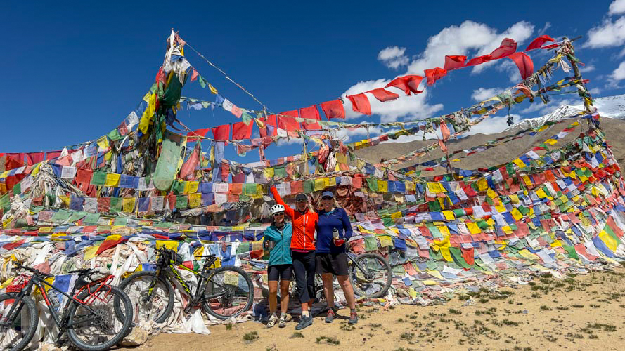
Extra Days in Leh
We are happy to book extra nights at Hotel Shaynam, one of our upgraded hotels, or another hotel of your choice if you want to stay in Leh for a few extra days to explore our favorite Central Asian capital, or just to relax and soak in the mountain scenery. We are also happy to book trips to Nubra, the high lake region (Pangong, Tsomoriri & Tso Kar), Kashmir and Srinagar, sightseeing jeep safaris along the Indus Valley, rafting, bicycling down the Kardung La or around Leh, or any other activity you’re interested in …
TRAVEL NOTE | If you have successive international flights that are not all part of the same ticket or following domestic flights we suggest planning more cautiously and leaving an extra day in Leh.
Date & Price
2026 Dates
14 June – 8 July
25 Days
2026 Trip Price
$5680
+ NO Single Supplement for Shaynam Hotel or Camping!
+ Flights NOT included (Meet in Leh)
+ Price for 3+ Cyclists
Includes
- Kim & Lhakpa Guides & Mechanic
- Hotels in Leh (Breakfast)
- NO Single Supplement for Shaynam Hotel or Camping!
- Leh Hotel Upgrade Options
- Restricted Area Permits
- Personalized Leh & Indus Sightseeing (With Kim – by Bicycle)
- Private Jeeps & Support Truck
- Airport Transfers
- Optional Rafting or Cycling Trips
- Kamzang Journeys Boutique Bicycle Trips
Single NorthFace tents (3-person tents), delicious, plentiful meals with seasonal, fresh produce, French Press organic coffee, Indian Chai, Kashmiri & herbal teas, ceramic filtered drinking water, warm washing water, trek library of books, full medical kit, our Kamzang ‘lounge’ tent with Indian cotton rugs, Crazy Creek camp chairs, blankets & occasional music in the evenings. For support, back up vehicles, and our 5-Star Kamzang Journeys team. Camping highlight is our signature ‘Yellow Tent of Eternal Happiness’.
Safety & Health Precautions
- Thuraya Satellite Phone (when allowed)
- Garmin InReach Satellite Messaging System (when allowed)
- Updated Route published on Garmin Site (when allowed)
- Helicopter Evacuation Services (when allowed)
- Oxygen Saturation Monitoring System
- PAC Bag (portable oxygen chamber)
- Oxygen (cost not included)
- Full Medical Kit + Stretcher
- Katadyn Filtered Water
- Safe, Sanitary, Delicious + Plentiful Food + Drinks
Excludes
- Domestic & International Fights
- Indian Visa
- Lunch & Dinner in Leh
- Bicycle Rental
- Travel & Travel Health Insurance
- Equipment rental
- Alcohol & Bottled Drinks
- Gompa (Monastery) Donations
- Laundry (staff will do for donations)
- Tips
Hotels in Leh | Extra Nights & Boutique Hotels
We use Hotel Shaynam, Hotel Chospa, Hotel Padma Ladakh, Leh Plaza & Hotel Omasila, as our arrival hotels depending on availability and your room preferences. Our standard hotel with no single supplement charge is the Hotel Shaynam. Kim and the Kamzang Journeys staff stay here, a lovely family-run guest house with a blooming garden, deck chairs, tables and umbrellas. We offer upgrade and single supplement charges for Hotel Chospa, Hotel Padma Leh, Hotel Leh Plaza and Omasila. We will book all hotels for you regardless of where you stay, so please specify your preference when booking a trek. Breakfast included in all of the hotels.
Hotel Shaynam
Hotel Shaynam
Extra Nights – Single $35 | Double $40
Hotel Chospa | Upgrade Charge
Chospa Hotel
Heritage Rooms – Single $165 | Double $185 Night ($825 & $925 Trip)
Hotel Chospa | Extra Nights
Heritage Rooms – Single $200 | Double $225 (KJ | $185 & $210)
Hotel Padma Ladakh | Upgrade Charge
Hotel Padma Ladakh
Garden Rooms – $10 Night Single & Double ($50 Trip)
Deluxe Rooms – $50 Night Single & Double ($225 Trip)
Super Deluxe Rooms – $80 Night Single & Double ($400 Trip)
Premium Rooms with Balcony – $100 Night Single & Double ($500 Trip)
Hotel Padma Ladakh | Extra Nights
Garden Rooms – Single $45 | Double $55 (KJ | $40 & $50)
Deluxe Rooms – Single $85 | Double $108 (KJ | $78 & $98)
Super Deluxe Rooms – Single $120 | Double $135
Premium Rooms – Single $145 | Double $160
Hotel Leh Plaza | Upgrade Charge
Hotel Leh Plaza
Super Deluxe Rooms – $40 Night Single & Double ($200 Trip)
Premium Rooms – $65 Night Single & Double ($325 Trip)
Hotel Leh Plaza | Extra Nights
Super Deluxe Rooms – Single $75 | Double $95
Premium Rooms – Single $100 | Double $120
Hotel Omasila | Upgrade Charge
Hotel Omasila
Heritage Rooms – $40 Night Single & Double ($200 Trip)
Suite Rooms – $90 Night Single & Double ($450 Trip)
Hotel Omasila | Extra Nights
Heritage Rooms -– Single $65 | Double $75
Suite Rooms – Single $125 | Double $135
Tips & Extra Cash
Allow approx $300 for meals (while not on trip), drinks (on trip) and tips. We recommend $350 per person thrown into the tips pool for the crew.
Map
Menu
Kamzang Journeys | Camping Menus
All meals on our Kamzang Journeys camping treks and cycling trips are prepared on site by our excellent chef Junar, our assistant chef Yam, and the hard-working kitchen team. The kitchen staff is well-trained in keeping the kitchen and food sanitized, and we sterilize all dishes, cups and utensils by steaming in boiling water before every use. All fruits and vegetables are soaked in iodine &/or baking soda, and our dining tent is well stocked with hand sanitizer, with soap and water for washing hands in front of the tent.
Much of our produce on the trip is organic, sourced from local villages to ensuring that it’s fresh, plentiful and sustainable We also buy meat, grains, potatoes, staples and whatever possible en route to provide much needed income to the local villagers. We cater to all sorts of dietary restrictions, including vegetarians and vegans, gluten-free, dairy-free and those with various food allergies and preferences. All of our meals are vegetarian, although most meals have additional meat options. Types of food we serve on our camping trips range from Asian (Nepali, Indian, Tibetan, Thai and Chinese) to Italian and Mexican, and we always have PLENTY of food to fill you up, and keep you fueled for the next day’s adventures!
Just one of the many reasons our trekkers and cyclists return year after year. A taste of what you’ll enjoy on our camping treks …
Breakfast
Freshly Ground Organic Coffee, Masala Chai & Teas
Freshly Baked Farmers’ Bread
Freshly Baked Wheat, Oat & Raisin Bread
Choice Of Eggs
Mexican, French & Masala Omelets
Aloo Anda (Potatoes & Scrambled Eggs)
Breakfast Burritos (Eggs, Tomatoes, Salsa, Cheese & Chapatti)
Huevos Rancheros (Eggs Rice, Beans Salsa & Chapatti)
Homemade Muesli
Porridges (Oat, Tsampa & Barley)
Crepes (Lemon, Chocolate & Local Apricot Jam)
Croissants (Sesame, Chocolate & Cheese)
Pancakes (Apple, Banana, Stacked & Buckwheat)
Dutch Baby Pancakes
Apple, Currant & Cinnamon Muffins
Cinnamon Spiced Rice Pudding
Cinnamon Rolls
Swedish Cardamon Rolls
Glazed Doughnuts
French Toast & Honey
Tibetan Bread With Local Jam
Cinnamon Sugar Chapattis
Masala Parathas & Sambar
Hash Browns
Fresh Fruit
Breads
Freshly Baked Farmers’ Bread
Freshly Baked Wheat & Oat Bread
Freshly Baked Cinnamon, Raisin & Nut Bread
Sun-Dried Tomato & Rosemary Flat Bread
Olive & Sundried Tomato Bread
Jalapeno & Cheese Corn Bread
Irish Soda & Currant Bread
Banana Bread
Zucchini Bread
Millet & Buckwheat Pancakes
Tai Roti (Paneer & Potato Bread)
Whole Wheat Roti & Chapattis
Cheese Biscuits
T Mo:Mos (Steamed Tibetan Bread)
Trail Lunch
Freshly Baked Breads
Himalayan Cheese
Herb & Olive Oil Paneer (Cottage Cheese)
Homemade Hummus & Baba Ghanoush
Herb & Olive Oil Infused Sun-Dried Tomatoes
Quinoa, Local Beans & Tahini Salad
Beet, Carrot & Cabbage Salad
Vegetable Fried Rice, Pilau & Biriyani
Kashmiri Rice (Coconut, Spices & Raisins)
Egg Fried, Lemon & Caribbean Tomato Rice
Mexican Rice & Beans
Thai Vegetable & Coconut Fried Rice
Vegetable Fried Potatoes
Potato & Celery Salad
Vegetable Fried Noodles
Chop Suey (Crispy Raman Noodles & Vegetables)
Tossed Pasta, Vegetable & Olive Oil Salads
Indian Samosas & Sweet Thai Chili
Millet Tabbouleh & Falafel
Smoked Salami
Tuna Salad
Deviled Eggs
Camp Lunch
Grilled Sandwiches (Tomato & Cheese, Cheese & Salami, Tuna & Cheese)
Tzadziki Wraps (Grilled Vegetables, Yogurt & Garlic)
Roasted Vegetable & Hummus Wraps
Asian Sesame & Bok Choy Noodles
Vegetable Spring Rolls & Asian Dipping Sauce
Chana Puri (Indian Chick Pea & Potato Ragout)
Sherpa Sha-Phaklay (Fried Mutton Flat Bread)
Baked Hand Pies (Vegetable & Paneer, Ham & Pea)
Thai Red Curry Coconut Noodles
Salads
Caesar Salad (Local Greens & Croutons)
Salad Niçoise & Isreali Salad
Beets, Paneer & Bread Panzanella
Soups & Stews
Fresh Pumpkin & Rosemary Soup
Fresh Potato & Spring Onion Soup
Fresh Carrot & Cilantro Soup
Fresh Chinese Tomato, Egg & Bok Choy Soup
Fresh Spinach & Mushroom Soup
Fresh Lentil & Local Beans Soup
French Onion Soup (Croutons & Cheese)
Fresh Nettle Soup
Spiced Coconut Carrot Soup
Fresh Pureed White & Black Bean Soup
Thai Tom Yum & Tom Kaa Soups (Bean Noodles)
Sherpa Shakpa (Potato, Shitake Mushroom & Vegetable Soup)
Tibetan Thukpa Noodle & Vegetable Soup
Asian Dried Mushroom, Ginger & Noodle Soup
Ramen Noodles With Egg & Vegetables
Thai Coconut & Coriander Soup
Tuscan Bread & Tomato Soup
Tomato Egg Drop Soup
Hot & Sour Soup With Chinese Dumplings
Spiced Chickpea Stew With Coconut & Turmeric
Dinner | General
Pizzas
Mexican Burritos
Mexican Baked Enchiladas & Rice-Beans
Southwestern Bean & Spinach Chili
Grilled Chicken & Mashed Potatoes
Quiche
Frittata
Couscous, Ratatouille & Italian Beans
Steamed Mo:Mos (Spinach, Paneer & Garlic, Potato & Cheese, Mutton)
Sherpa Potato Pancakes & Somar (Fermented Cheese, Green Onions & Chili)
Sherpa Shakpa (Potato & Vegetable, Potato (&/Or Meat) Stew)
Tibetan Thukpa (Noodle, Vegetable Soup)
Potato, Cheese, Onion (& Ham) Casserole
Mutton & Vegetable-Lentil Burgers
Polenta, Baked Vegetables & Cheese
Tuscan Fish & Potato Ragout
Gnocchi
Sushi Rolls
Dinner | Pasta
Spaghetti, Linguine & Penne Pastas
Italian Pasta Sauces (Vegetable, Garlic & Olive Oil, Bolognaise, Puttanesca, Carbonara)
Tossed Pastas (Pesto & Sun-Dried Tomatoes, Sautéed Garlic, Olives & Mushroom)
Lasagna (Spinach, Mushroom, Eggplant & Tomato)
Ravioli With Tomato, Spinach & Garlic Sauce (Mushroom & Spinach, Mushroom & Cheese, Ham, Pumpkin & Rosemary)
Mongolian Fried Sesame & Ginger Noodles (Vegetable & Mutton)
Dinner | Rice
Thai Masman, Panang, Red & Green Coconut Curries (Vegetable Or Chicken)
Bhutanese Ema Datsi (Chili & Cheese, Mushroom Or Potato)
Palak Paneer (Spinach & Paneer)
South Indian Coconut Vegetable & Chicken Curries
Shahi Paneer, Vegetable & Chicken Curries (Yogurt)
Butter Chicken & Mutton Masala Curries
Indian Masala Curries (Vegetable, Cauliflower, Mushroom, Pumpkin, Potato & Pea)
Masala Kofta (Potato & Paneer Curry)
Dal Makani (Black Dal & Butter) & Local Dals (Lentil Curries)
Asian Ginger Broccoli & Sesame Cabbage
Asian Black Bean Sauce (Vegetables & Tofu)
Chinese Egg & Tomato Curry
Chinese Stir-Fried Vegetables
Poha (Indian Flattened Rice)
Vegetables, Beans & Potatoes
French Fries (Chips)
Mashed Garlic & Roasted Potatoes
Italian Rosemary Sauteed Potatoes
Roasted Rosemary Beets & Sweet Potatoes
Italian Sauteed White Beans, Cabbage & Potatoes
Italian Sauteed Garlicky White Beans, Broccoli (Kale) & Lemon
Lana’s Stacked Green Vegetables (& Cheese)
Mashed Garlic Cauliflower
Baked Zucchini & Egg Casserole
Eggplant & Zucchini Parmesan
Stuffed Capsicum, Squash & Zucchini
Steamed Broccoli & Cauliflower, Olive Oil & Lemon
Coconut Sesame Vegetables
Japanese Vegetable Tempura
Chinese Ginger Vegetables
Alu Sandekho
Snacks
Cheese, Pate & Crackers
Potato Cheese Balls
Masala Papadum & Peanuts
Jalapeños & Cheese Quesadilla
Bruschetta (Tomato, Olive Oil & Olive Tapenade)
Garlic & Olive Oil Crustini
Tempura (Vegetables, Paneer & Rice Flour)
Pakora (Vegetables & Chick Pea Flour)
Green Pea Guacamole
Stuffed Pea Parathas
Indian Pakora & Tempura
Fried Potato, Rice & Corn Snacks
Cumin Nimkins
Desserts
Fresh Fruit Salad
Coffee-Infused Dark Chocolate Dumplings
Chocolate, Muesli & Nut Fortune Cookie Pastries
‘Marie’ Rum, Raisin & Chocolate Balls
Mango & Apple Cinnamon Crepes
Apple Pie & Crisp (Crumble)
Apple & Apricot Tarte
Apple, Apricot, Banana, Papaya & Plum Cobblers
Apple & Banana Fritters
Banana Flambe
Gulab Jamun (Indian Doughnut Holes)
Homemade Spiced Apple Sauce
Homemade Apple Pie
Apple, Carrot, Ginger & Pumpkin Spice Cakes
Bread & Butter Pudding
Spiced Pumpkin & Apple Suiji
Grated Apple Suji (Indian Semolina)
Soan Papdi (Indian Halva) & Kheer
Dark & White Chocolate Chunk Custard
Chocolate Chunk Pan Cookies
Dark Chocolate-Covered Digestives
Chai Masala Cookies
Lemon Bars
Brownies
No-Bake Chocolate Oat Bars (Peanut Butter)
Dark Chocolates
Coffee, Teas & Hot Drinks
Organic Coffee Beans
Masala Chail
Kashmiri Spiced Green Tea
Green & Assam Teas
Variety Of Dilmah Teas
Hot Chocolate
Lemon Ginger Tea
Grog
Kamzang Hot Rum Punch
Local Beers & Rum
Highlights & Reviews
Kamzang Journeys Reviews
Why Travel with Kamzang Journeys?
Why Trek with Us?
Kamzang Journeys Reviews!
Kamzang Journeys Reviews
Cycle Trip Highlights
- Epic Himalayan Bicycling
- Approx 900 Kilometer Bicycle Trip
- Approx 12,000+ Meters Total Altitude Gain
- Exotic Leh + Historic Indus Valley
- Otherworldly High Salt Lakes (Tso Morori, Tso Kar + More)
- Cycle Over The Kardung La + Wari La (both 5300+ meters)
- Desert-like Nubra Valley, Bactian Camels, Oasis Villages + Sand Dunes
- Cycling along the Shayok River
- Traditional Ladakhi Villlages
- Camping with Nomads + Nomadic Life (Yaks, Nomadic Tents, Pashmina Goats, Salt Butter Tea)
- Himalayan Passes + Snow Peaks
- Buddhist Ladakh + Tibetan Buddhist Monasteries
- Great Campsites
- Central Asian Wildlife
- Challenging Cycling, Good Roads
- Lots of Exploration
- Our Kamzang Journeys ‘Boutique’ Campsites!
- Our Kamzang Journeys Wonderful Food!
Client Highlights
I have trekked with Kim seven times and she is the best! Her organization and planning are meticulous. She puts safety first. Always enjoyable trekking with her and her crew, and the food is fantastic too!
– Peter Hunt (UK), The Great Ladakh Bicycle Adventure 2024
Excellent! Most challenging but very good, and everything was well organized, so no complains. I would recommend this trip to anyone who is interested in a bit of cycling adventure!
– Herb B (Australia), The Great Nepal Bicycle Journey 2022
A wonderful bicycle tour of Ladakh & Zanskar, the Indian Himalaya!
Cycle-eat-relax-repeat. I had met Kim Bannister & Lhakpa Dorji previously, but this was my first trip with them as formal leaders. Kim & Lhakpa have all of the logistics for fun and relaxing Ladakh travel completely dialed in. The itinerary was challenging but not overly so, with the flexibility to ride in the support vehicle completely open at any time. Very importantly, our two drivers were 100% calm and safe. Cycling ranged from 4 – 8 hours a day. The team uses cell phones and radios for communications to coordinate camps and timing. Each cyclist also has a personal radio for potential emergency use, but in reality, even though we had some tough days, there were zero emergencies. Camp is set up and struck efficiently by the crew. Snacks and hot and cold drinks await on arrival in the afternoon, with large, comfy personal tents set up in nice locations and your personal gear stashed inside. It has been said an army marches on its stomach, and for any trip of this sort, the food is of paramount importance. Junar and the rest of the crew never failed to impress with tasty, copious and varied food choices, including melons, momos, salads, and a birthday cake!
– David K (USA), Ladakh Sky Kingdoms Ladakh Cycling Journey 2019
From Lhasa to Kathmandu – Cycling across the Tibetan Plateau!
I can only highly (once more, highly) recommend Kamzang Journeys. Absolutely top notch experience, when it comes to exploring the remote Himalayas, by either hiking or biking. This time, we have cycled across the Tibetan Plateau for about 1000 kms. Stunning. Magnificent. Mesmerizing. Adventurous. And safe. Superb logistics, organisation & Team (really!). Deep insights into the Tibetan culture from a beautiful soul who has been living the Himalayan spirit for nearly 20 years. Kamzang Journeys will make your experience an unforgettable memory. Kim & Lhakpa are knowledgeable (this is an understatement), are passionate about the region, its people and their culture & traditions. Food is truly beyond expectations, camp sites always stunning & relaxing, and Kim & her Team will go the extra mile to secure your safety. Full disclosure: over the past 11 years or so, i have repeatedly returned to Kamzang Journeys for the joy of experiencing the Himalayan region, with authenticity & simplicity, as most of their customers do. (and this is a testimony of the quality & the love of their “services”). Kamzang Journeys: you rock!
– Laurence V (France), The Great Tibet Bicycle Trip June 2018
The experience I had when I travelled with Kamzang Journeys was incredible. The team, as well as the guides, were fantastic and extremely helpful. Kim made you feel very safe and comfortable and had great knowledge, and the sights, characters and the culture were a dream. Definitely worth it and I will definitely go again.
– Nita B (New Zealand), The Great Tibet Bicycle Trip June 2018
When I first searched online for a Nepal trekking guide in 2006, I found Kim Bannister. I was most impressed by the fact that the person leading my trek was the one answering my emails and that she evidenced a commitment to an environmental ethic and to treating her staff (and, when relevant, the pack animals) with respect and fairness. Not one other company mentioned any kind of valued ethic, let alone provided a personal response. Back then I was inquiring about a trek to the Everest Region, a bucket list dream of mine. Though I have since made that journey with Kim, I did not go in 2006, because Kim provided the honest insight that summer was not a good time to go to the that region due to the monsoon and suggested Ladakh instead. Though I was sure Everest was the only place I wanted to go, I jumped at the alternative adventure, already trusting Kim’s expertise and knowing that I was to be led by a capable, reasoned guide. I have since trekked with Kim to Dolpo, Everest High Passes, and just returned from the cycling trek with Kim from Lhasa to Kathmandu. In 2007 Kim also set up a Tibet jeep trip for me and has connected me to contacts in India. I trust Kim implicitly. Every place one might travel in the entire Himalayan region — Nepal, India, China, Bhutan — is, by its nature, wildly unpredictable, from the weather, to closed borders, cancelled flights, lost luggage, runaway animals, altitude sickness, and beyond. Kim manages such fluidness with impressive agility, resource, and calm. We have shared quite a few wonderful stories, laughs, amazing food, and our share of beer over these adventures. As myself an experienced outdoor educator and leader, risk management consultant, and now attorney, my 2006 bet with Kim has paid off exquisitely. Stop looking now — you have found the best.
– Anne M (USA), The Great Tibet Bicycle Trip June 2018
Lhasa to Kathmandu Bicycle Trip: A difficult trip to organize went wonderfully. Fantastic food. Great people. Don’t know how it could have been better!
– Grant E (New Zealand), The Great Tibet Bicycle Trip June 2018
From Lhasa to Kathmandu – Cycling across the Tibetan Plateau!
I can only highly (once more, highly) recommend Kamzang Journeys. Absolutely top notch experience, when it comes to exploring the remote Himalayas, by either hiking or biking. This time, we have cycled across the Tibetan Plateau for about 1000 kms. Stunning. Magnificent. Mesmerizing. Adventurous. And safe. Superb logistics, organization and team (really!). Deep insights into the Tibetan culture from a beautiful soul who has been living the Himalayan spirit for nearly 20 years. Kamzang Journeys will make your experience an unforgettable memory. Kim & Lhakpa are knowledgeable (this is an understatement), are passionate about the region, its people and their culture & traditions. Food is truly beyond expectations, camp sites always stunning & relaxing, and Kim & her Team will go the extra mile to secure your safety. Full disclosure: over the past 11 years or so, I have repeatedly returned to Kamzang Journeys for the joy of experiencing the Himalayan region, with authenticity & simplicity, as most of their customers do. (and this is a testimony of the quality & the love of their ‘services’). Kamzang Journeys: you rock!
– Laurence V (France), The Great Tibet Bicycle Trip June 2018
Lhasa to Kathmandu Bicycle Trip. A difficult trip to organize went wonderfully with Kamzang Journeys. Fantastic food. Great people. Don’t know how it could have been better!
– Grant E (New Zealand), The Great Tibet Bicycle Trip June 2018
The experience I had when I cycled with Kamzang Journeys was incredible. The team, as well as the guides, were fantastic and extremely helpful. Kim made you feel very safe and comfortable and had great knowledge, and the sights, characters and the culture were a dream. Definitely worth it and I will definitely go again.
– Nita B (New Zealand), The Great Tibet Bicycle Trip June 2018
The Great Tibet Bicycle Trip!
When I first searched online for a Nepal trekking guide in 2006, I found Kim Bannister. I was most impressed by the fact that the person leading my trek was the one answering my emails and that she evidenced a commitment to an environmental ethic and to treating her staff (and, when relevant, the pack animals) with respect and fairness. Not one other company mentioned any kind of valued ethic, let alone provided a personal response. Back then I was inquiring about a trek to the Everest Region, a bucket list dream of mine. Though I have since made that journey with Kim, I did not go in 2006, because Kim provided the honest insight that summer was not a good time to go to the that region due to the monsoon and suggested Ladakh instead.
Though I was sure Everest was the only place I wanted to go, I jumped at the alternative adventure, already trusting Kim’s expertise and knowing that I was to be led by a capable, reasoned guide. I have since trekked with Kim to Dolpo, Everest High Passes, and just returned from the cycling trek with Kim from Lhasa to Kathmandu. In 2007 Kim also set up a Tibet jeep trip for me and has connected me to contacts in India. I trust Kim implicitly. Every place one might travel in the entire Himalayan region — Nepal, India, China, Bhutan — is, by its nature, wildly unpredictable, from the weather, to closed borders, cancelled flights, lost luggage, runaway animals, altitude sickness, and beyond. Kim manages such fluidness with impressive agility, resource, and calm. We have shared quite a few wonderful stories, laughs, amazing food, and our share of beer over these adventures. As myself an experienced outdoor educator and leader, risk management consultant, and now attorney, my 2006 bet with Kim has paid off exquisitely. Stop looking now — you have found the best.
– Anne M (USA), The Great Tibet Bicycle Trip June 2018
Kim Bannister specializes in leading adventurous, culturally knowledgeable active trips in the Himalayan region. She has extensive local contacts and stable, top quality local crews. In addition to the better known Nepal destinations, she runs ambitious trips in the Indian Himalaya. She is equally at ease with her guests and clients, her staff, and local people. Kim genuinely loves what she does and the mood is infectious on her trips.
– David Koelle (USA)
Himalaya Bicycle Trip Photos
Cycle the Himalaya
Kim Bannister Photography | Trek & Travel Photos
Himalayan Trip Photos
Travel Reading | Enhance Your Trip!
Travel Books
Articles & Documentaries | Ladakh & Zanskar, Indian Himalaya
Kamzang Journeys | The Ladakh Great Himalayan Bicycle Trip | David Koelle | YouTube Video
Stunning Time Lapse of Ladakh in 4K | Reels & Frames
Becoming a Woman in Zanskar | Jean-Michel Corillion
Ladakh Diaries | Postcard from Paradise | India Today – Features Kamzang Journeys
Nomads in Ladakh: Hard Living at Altitude | Blog by France LeClerc
On Snow Leopard Mountain | BBC Planet Earth
Child Monks of the Himalayas | BBC – In Pictures
Chang Tang Pa | Cat Vinton Photo Essay
Silent Roar, The Snow Leopard | National Geographic Documentary
Shepherdess of the Glaciers | Trailer YouTube
Ladakh, Mountains & Men | Le Figaro
Blog Article | Za Rahula Local Nomadic God
Ladakh, the Last Shangri La | National Geographic
A Journey to Little Tibet | National Geographic
Legends of Dha Hanu | Stephan Kloos
India: Extreme Biking in Beautiful Ladakh | The Telegraph UK
The Grey Ghosts of the Mountains | Vimeo
Kashmir, the Inheritance of Loss | New York Times
Cracking India’s Mystifying Nod Code – BBC Travel
The Ravishing Art of Alchi – NY Times Books
The Planet Doesn’t Need Money, It Needs Behavioral Change: Sonam Wanchuk | The Week
A Brother’s Five Decade Search for a Lost King From Ladakh | A Better India
The Ice Stupas | New Yorker
Yak Herders’ Vanishing Way of Life | New York Times
Himalaya, Land of Women | Marianne Chaud ZED Arte France
Our World Return to Zanskar | BBC
Kashmir & Srinagar
A Journey to Kashmir’s Gurez Valley | NY Times
Kashmir, the Inheritance of Loss | New York Times
What is Article 270 & Why Does it Matter in Kashmir? | New York Times
Haider | Film about Kashmir
Fascinating Delhi & India Article Series
Jungle Prince of Delhi | NY Times
Mystery of the Royal Family of Oudh Unravels a Bit More | NY Times
Special Episode | The Jungle Prince | NY Times
Street Food in India | India Mike Blog
Gandhi & India | BBC Documentaries
In Search of Gandhi | BBC Documentary
The Making of the Mahatma – Part 1
Ladakh Cycling Videos
Nubra – Wari La Cycle | David Koelle
Lamayuru, Leh, Nubra + Khardung La Cycle – | David Koelle
Pangong Lake + Chang La Cycle | David Koelle
Srinagar – Lamayuru Cycle | David Koell
Leh – Manali Cycle | David Koelle
Kamzang Journeys | Ladakh Trek Videos
Kamzang Journeys | Kharnak Nomads | MennoBen
Kamzang Journeys | Markha Valley | MennoBen
Kamzang Journeys | Changthang Nomads | MennoBen
Kamzang Journeys | Rupshu Nomads | MennoBen
Leh & Indus Valley | MennoBen
Contact & Details
Kamzang Journeys
https://kamzangjourneys.com/
kim@kamzang.com, kamzangkim@gmail.com
info@kamzang.com
Kim Bannister, Chez Kim, Lazimpat, Kathmandu, Nepal
Kamzang Journeys LLC, USA
India Contacts
Kim Mobile (Jio): +(91) 70067 70368
Kim Mobile (AirTel): +(91) 70517 97837
Lhakpa Mobile (Jio): +(91) 9419 977569
Lhakpa Mobile (AirTel): 96229 75461
Kim’s WhatsApp: +(977) 9803414745
Lhakpa’s WhatsApp +(977) 9841235461
Khumbu Adventures (Nepal)
Lhakpa, Doma & Nuru Sherpa
Lhakpa Mobile: +(977) 9841 235461 (WhatsApp), 9823 905461
Doma Mobile: +(977) 9841 510833, 9803 675361
Nuru Wangdi Mobile: +(977) 9803633783 (WhatsApp)
www.khumbuadventures.com
hiking.guide@gmail.com, nuruwangdi@gmail.com
Srinagar & Kashmir Contact
Shangaloo Travels
Mehraj Deen (GM & Ladakh Operations)
mehraj@shanglootravels.com
Mehraj Mobile: +(91) 9419013874, 9858986512
Office: +(91) 0194 2502083
Shangaloo Travels Tel : +(91) 0194 2502082-90, +(91) 9596 787001-20
On-Trek Contact
We are not able to use our satellite phone in India or Ladakh because of security restrictions. In case of emergency, a few numbers are listed below, or contact Doma or Nuru Sherpa of Khumbu Adventures in Nepal. We sometimes have access to landlines during the trek, and will try to use our Garmin InReach for text messaging.
Padma Deachen Mobile (Shaynam Hotel): +(91) 70510 49977 (WhatsApp)
Jigme Mobile (Shaynam Hotel): +(91) 96229 96242 (WhatsApp)
Jigmet Punchok (Driver & Leh Company – Adventures La): +(91) 99062 49085 (WhatsApp)
Ang Chuk Mobile (Driver & Friend): +(91) 94193 44641 (WhatsApp)
Tenzin Wanga Email (Ang Chuk’s Son): tenzinw5@gmail.com
Communications on Trek | Garmin InReach Messaging Service
Kamzang Journeys has a Garmin MapShare page for sending + receiving messages to our Garmin InReach satellite messaging device. Give this link to friends + family who want to follow our progress on the trek, have them send us a message so we have their email in the system. We can message them back directly, email works better than texts. Messages are free, enjoy.
https://share.garmin.com/KimBannister
Kim will post InReach updates to the Kamzang Journeys Facebook page.
Satellite Phones & Drones in India
Satellite phone, Garmin InReach, SPOT or satellite communications of any sort are STRICTLY PROHIBITED in India! Serious consequences, please leave yours at home! Drones are also illegal in Jammu & Kashmir unless registered with the appropriate government office in Delhi.
Kamzang Journeys FaceBook
https://www.facebook.com/kamzangjourneys/
Posts from Leh before + after the trek.
Kamzang Journeys | Kim Bannister Photography
https://kimbannisterphotography.smugmug.com/
Kamzang Journeys Blog
https://www.kamzangjourneys.com/kamzang-journeys-blog/
Shop Kamzang Journeys Products
https://www.kamzangjourneys.com/store/
Shop Kamzang Design
https://www.etsy.com/shop/KamzangDesign
The Kamzang Fund
Sponsoring Children, Medical Issues and Giving Back to Himalayan regions.
https://www.kamzangjourneys.com/kamzang-fund/
Travel Books
https://www.kamzangjourneys.com/kamzang-journeys-travel-books/
Arrival Hotels Leh
Hotel Shaynam
Hotel Omasila
Padma Guest House
Hotels in Leh | Alternative & Luxury Hotels
We use Hotel Shaynam, Padma Guest House or Hotel Omasila as our arrival hotel, depending on availability and your preference. Our standard hotel is the Hotel Shaynam where Kim and the Kamzang Journeys staff stay, a lovely family-run guest house with a blooming garden, deck chairs, tables + umbrellas. We don’t charge a single supplement at Hotel Shayman. We charge a single supplement for Omasila and Padma, and a double upgrade for Omasila. We will book all hotels for you regardless of where you stay. Please specify your preference when booking a trek. Breakfast included in all of the hotels.
Leh Alternative & Luxury Hotels
We will confirm current prices yearly, please inquire …
Alternative Hotels
We’re happy to book other hotels of your choice. Some recommended hotels below.
Hotel Royal Ladakh
Single Supplement – $225
Extra Nights – Single $80, Double $90, Suite $115
Breakfast Included
Dragon Hotel
Single Supplement – $200
Extra Nights – Single $70, Double $80, Suite $120
Breakfast Included
Luxury Hotels
Spash out on one of Leh’s most luxurious hotels! We will be happy to make any bookings needed. Enjoy!
The Grande Dragon Ladakh
Single Deluxe $220, Single Suite $210
Breakfast Included
The Zen Ladakh
Single/Double Premium $155/$180
Zen Cottage – $250
Executive Suite – $310
Presidential Suite – $340
Nimmu House
Nimmu Village (45 Minutes from Leh)
4 Rooms + 5 Tents
Single/Double Rooms – $170/$190
Single/Double Luxury Tents – $185/$205
Pangong Serai
Single Supplement – $50 Per Night
Extra Nights – $50
Breakfast Included
Lunch + Dinner – $20 Per Meal
Travel Medical Insurance
Required for your own safely. We carry a copy of your insurance with all contact, personal and policy information with us on the trek and our office in Kathmandu keeps a copy. Note that we almost always trek over 4000 meters (13,000+ feet) and that we don’t do any technical climbing with ropes, ice axes or crampons.
Note that private helicopter insurance generally not available in India!
Travel Medical & Travel Insurance
TRAVEL MEDICAL INSURANCE is required to travel with us. We strongly recommend TRAVEL INSURANCE as well in case of international or domestic flight cancellation or unexpected costs on the trip such as helicopters when flights are cancelled or passes are impassible. Your insurance must include HELICOPTER EVACUATION and travel over 4000 meters (over 13,000 feet). In INDIA and TIBET helicopter evacuation is more difficult, although we still recommend including this option in your policy. Please do your own research, check with your local insurance provider for the company best for your country, age and trip requirements.
INSURANCE NOTE | Please bring us a PRINTED PAGE with your name, address, personal emergency contact, insurance policy name and number and the overseas contact number to call in case of emergency for us to give to our local agents (we don’t need the particulars, just a one-page copy of the policy).
Global Rescue Services
Safety is our top priority, but unforeseen emergencies can occur on any trek, cycling trip or journey. A Global Rescue membership will provide you with 24 hour advisory services, field rescue (evacuation from your point of injury or illness to the nearest appropriate medical facility), and also evacuation to your home hospital of choice for continuing care all at no cost to you. You can purchase the coverage directly from Kamzang Journeys, with or without the IMG travel medical insurance coverage.
Global Rescue Services
Global Rescue & IMG Travel Medical Insurance
https://globalrescue.com/kamzang/
Travel Medical Insurance Suggestions
Travel Guard & AIG Travel Insurance
http://www.travelguard.com/
HTH Travel Insurance
https://www.hthtravelinsurance.com/
Allianz Care Travel Insurance
https://www.allianzcare.com/en/personal-international-health-insurance/travel-insurance.html
Adventure Sports Cover 360
https://asc360.com/
TravelEx Insurance
https://www.travelexinsurance.com/
AXA Travel Insurance
https://www.axatravelinsurance.com/
CoverMore Travel Insurance
https://www.covermore.com/
World Nomads Travel Insurance
http://www.worldnomads.com/
Seven Corners Travel Insurance
https://www.sevencorners.com/insurance/HW35TW3
Generali Global Insurance
https://us.generaliglobalassistance.com/
World Trips Atlas Travel Insurance
https://www.worldtrips.com/travel/insurance/Atlas-International-Insurance/
Ripcord Travel Insurance
http://www.ripcordrescuetravelinsurance.com/
International Association for Medical Assistance to Travelers (IAMAT) – FREE Membership
www.iamat.org
Helicopter Service & Rescues Leh, Ladakh
Please pass on this information to your travel medical insurance provider …
HeliService Ladakh (Government Agency)
https://heliservice.ladakh.gov.in/
+91 01982-255567, contact@heliservice.ladakh.gov.in
Ladakh Rescue Center
Mr. Nasir Mohd
+91 96229 98919, 94194 41333, nasiradvo786@gmail.com
Working together with:
Pawan Hans Helicopter Service (Government Regulated))
https://www.pawanhans.co.in/english/index.aspx
Medical
We have a full medical kit with us including Diamox (for acclimatizing), antibiotics, inhalers, bandages, re-hydration, painkillers, anti-inflammatory drugs etc. but please bring a supply of all prescription and personal medications. Kim has First Aid, CPR and Wilderness First Responder (WFR) certifications as well as many years of experience with altitude in the Himalaya but is NOT a qualified medic or doctor, so please have a check-up before leaving home, and inform us of any medical issues. This is for YOUR OWN safety.
DO bring all prescription medications and good rehydration/electrolytes. We advise bringing your own Diamox, Ciprofloxin, Azithromyacin & Augmentin. We have all of these with us but the Western versions are always better than the Indian equivalents.
PAC Bag & Oxygen
We carry a Portable Oxygen Chamber, or Gammow Bag, with us on many treks. There is no charge for use of the PAC bag but oxygen is $300 per canister (cost price, pass on to insurance company).
Health Information
India Health Information
CDC
We also recommend bringing probiotics with you to help prevent infections while on trek. Doctor’s recommendation!
Arrival India
Arrival in India
ARRIVAL NOTE | Flights to/from Leh are NOT included in the price or itinerary. Everyone will need to arrange their own flight or overland trip to Leh. You can book your international flights all the way to Leh, Ladakh (IXL) which will ensure that your flight provider is responsible for hotels if your flight is delayed or cancelled. You might also want to come overland from Manali, breath-taking jeep safari, or from Srinagar, both some of the planet’s most spectacular drives.
Email us your flight arrival details and have our contact details with you when you arrive in Delhi in case you need assistance. Kim will have her mobile with her, as will our agents from Dhruv Travels, so don’t hesitate to call. We can help with hotels, flights, airport pick-ups and drops, sightseeing in Delhi or travels further to Rajasthan or Agra & the Taj Mahal (see Dhruv Travels).
GET YOUR INDIAN VISA
You can get your Indian e-Visas (visa-on-arrival) online, either at the Indian government website or at the easier, and slightly more expensive iVisa website. Extensions are possible but very difficult. You must have your visa BEFORE arriving in India!
INDIAN GOVERNMENT SITE
https://indianvisaonline.gov.in/evisa/tvoa.html
https://indianvisaonline.gov.in/evisa/Registrationi
VISA
https://www.ivisa.com/india-visa-application
INDIAN VISA REFERENCE & ADDRESSES
Hotel Leh: Shaynam Hotel, 20 Old Leh Road, Leh, Ladakh, 194101
+(91) 70510 49977
Contact: Jigmet Singay Dadul &/or Padma Deachen
Mobile: +91 70510 49977 (Padma)
Mobile: +91 96229 96242 (Jigmet)
EXAMPLE:
Reference Name: Padma Deachen
Address: 20 Old Leh Road
Line 2: Ladakh
State: Jammu & Kashmir (or Ladakh, when the system is updated)
District: Leh
Phone: 70510 49977 (don’t need +91)
NOTE: Don’t add spaces or +country code when adding your phone or mobile numbers.
Travel Agent Delhi: Dhruv Travels, 2464, Nalwa St, Chuna Mandi, Paharganj, New Delhi, 110055 (Tel: +91 11 2358 2715)
Kim’s Mobile: +(91) 9419 981715
Satellite Phones & Drones
Satellite phones are ILLEGAL in all of India, including Jammu & Kashmir. If you are caught with a satellite phone, SPOT, Garmin InReach or another satellite device it will be confiscated, you will be fined and the owner might go to jail or be restricted from re-entering India. This is serious!
Drones are also illegal in Jammu & Kashmir unless registered with the government in Delhi.
Delhi Hotels
Some suggestions for extra nights + layovers in Delhi, near the airport
Marriott Aero City
The Muse Sarovar
Red Fox
Holiday Inn (Airport)
Andaz Delhi
Architectural Digest Article on Andaz
Delhi Restaurants & Bars
Zomato Restaurant Reviews
Notes on Itinerary
Although we try to follow the itinerary below, it is ONLY a guideline based on years of experience trekking in the Himalaya. At times local trail, river or weather conditions may make a deviation necessary; rivers may be impassible, snow blocks passes, and landslides wipe out trails. The trekking itinerary and campsites may also vary slightly depending on the group’s acclimatization rate or sickness.
The Himalaya are our passion, and we take trekking seriously. Although everyone is here on vacation, please come with a dollop of patience and compassion added to your sense of adventure …
Temperatures & Clothing
Dress conservatively in Leh and on the trail as a rule. Shorts are okay if they aren’t too short, mini skirts aren’t recommended. Sleeveless t-shirts are absolutely fine, but perhaps avoid tank-tops on the trail. Super tight doesn’t go over so well with the village elders. Many of the younger generation in Nepal wear modern Indian or Western-influenced clothes, but remember that you haven’t signed up for a beach or surf vacation. Use your good judgment, be an ambassador for western tourists! Please ask Kim or your guide if unsure about appropriate clothing.
Leh is generally very hot during the day (t-shirt weather) and cool at night (long sleeve shirt, fleece or synthetic jacket weather depending on month in the summer). A sun hat is essential during the day, sandals like Keens perfect for both a wander around town and trekking. Ladakh is very casual, a pair of jeans and shirt fine for evenings.
Trekking temperatures vary considerably, and you will need a wide range of trekking gear during the trek. Gear will range from sandals to boots, from t-shirts to down jackets. We suggest packing a warm sleeping bag, and bring layers. A full discussion of gear on ‘Gear’ tab.
Cultural Issues
Ladakhis are very open and welcoming, but there are a few issues you should be aware of to make your stay in Ladakh more fulfilling. Use your right hand to pass things, shake hands or do most anything. Left hands are somewhat taboo. Best not to pat kids on heads, or point feet ahead of you at monasteries. Don’t walk over someone’s legs or feet, but put your hand down in front of you to signal them to pull their legs to the side. Take off shoes and hats when going into Buddhist monasteries and Hindu temples, don’t use flashes inside monasteries or temples in general, be respectful of a puja (prayer ceremony) if attending one. You can talk, all religious are very tolerant, but be aware of your level of voice.
Ladakhis don’t anger quickly, so try not to raise your voice if exasperated or angry as it only will make a situation worse. Do bargain at shops, with taxis and rickshaws, but don’t fleece them. They are poor and making a living, generally.
Give small donations on the streets if you choose, but try not to encourage begging too much. Be aware of who you are giving money to, and please only give small amounts. If you do want to donate to a cause, ask about our Kamzang Fund or other responsible organizations.
Note that Leh and Ladakh are melting pots of different religions: Buddhist, Hindu and Muslim, as well as a few Christians. Tolerance and acceptance of all religions tolerated!
Pampering Yourself in Leh
Inquire if you’re interested in staying in one of Leh’s high end hotels. A few suggestions …
Stok Palace
‘Built entirely by the Ladakhi craftsmen in 1820, the Stok Palace still continues to be a snug abode for the Namgyal dynasty. The Namgyal dynasty traces its origin to its founder –Lhachen Palgygon as early as 10th century. You are entering a historical property and the Palace stands 195 years old. The Stok Palace was opened to public in 1980 with blessings of His Holiness the Dalai Lama and since it’s been over a decade and visitors continues to pour from all over the World. It encapsulates and reflects the lifestyle and history of Royalties set in the midst of the valley of Singey Sangpo which is known more popularly as Indus River.
Preserved from urbanity, this pristine natural landscape allows you to relax in serene atmosphere, pregnant with the delicious aroma of the country side and amazing views all around and takes the visitors through the imagery experience, detailing the softness of Snow, the brilliance of sunlight, billowing clouds, wandering pathways, and picturesque local architecture. As with anything embracing the grandeur and beauty of nature, the landscapes achieve a sense of timelessness; they envelop the echoes and silence of eons gone by. So come and enjoy the fine dining experience prepared from the family kitchen products coming from the local market and village. You can enjoy the pleasures of healthy and natural Ladakhi, Tibetan and Indian food.’
Nimmu House
‘Nimmu House Ladakh is a sustainable Hotel in Ladakh, 30 km from Leh, in the village of Nimmoo. A noble house belonging to the cousin of the king of Ladakh, from the early 90s, surrounded by an orchard. Nimmu House includes five spacious tents scattered across the orchard and a room located in the house. Activities include Hiking, trekking, rafting, cooking classes, visits to the village of Nimmu and the monasteries of the Indus Valley’
The Ultimate Traveling Camp
‘The first truly mobile luxury camps in India covering a calendar of destinations and festivals. This nomadic super luxury camp introduces the discerning traveller to different adventures in Carefully selected exceptional locations in the mountains, deserts, jungles and unexplored Countryside. Experience the many moods of exotic India with its dramatic landscapes, rustic and unexplored rural surroundings. Rediscover yourself…meet gurus from the far reaches of the Himalayas, raft down the River Indus, watch a game of Polo, a sport of the Royals, picnic in picturesque spots, celebrate tribal hues at the Hornbill Festival, explore quaint tribal Naga villages, or simply curl up in your ‘tent with a view’!
Tips for Staff
We recommend at least $200 per person to go into the tip pool for the staff. Please bring IC with you on the trek for the tips. It’s nice to buy the staff drinks on the last night. Or any other night that you feel like getting them a bottle of run!
Tips in General
Tips are always appreciated but they don’t need to be extravagant. 50 IC to carry bags to/from your room is fine. 100 IC for drivers to/from the airport. Round up taxi fares. A larger tip would be expected for a day trip in a car, perhaps 500 IC. 10% is included in some restaurant and hotel bills in India, and if it’s not included it’s still expected. Check your bills, and still round up at restaurants. Feel free to give out small change to the beggars in the streets (5, 10, 20 IC).
Cash & ATMs
You’ll want some cash with you on the trek for drinks, snacks, beer, sodas, etc. There are often chances to during the trek, and usually local crafts to buy en route. (You’ll want your tip money IC as well). There are ATMs in Leh but they don’t dispense large amounts of cash so you’ll be best with currency to change. Traveler’s checks not recommended in India.
Extra Days in India | Customize Your Journey
We are happy to book extra nights at the hotel, or a hotel of your choice, if you want to stay in Leh for a few extra days to explore our favorite Central Asian capital, or just to relax and soak in the mountain scenery. We are also happy to book trips to Nubra, sightseeing jeep safaris along the Indus Valley, rafting, bicycling down the Kardung La or any other activity you would like.
See our Extensions Tab for trip ideas!
Gear
Kamzang Journeys Products
Kamzang Journeys duffel bags, t-shirts, camp towels and buffs. Handcrafted leather passport wallets, totes and bags, unique Himalayan textile pillow covers, cashmere stoles and more!
Kamzang Journeys Products
Gear List (Camping Treks)
A guideline, not a bible, for the gear you will (probably) need on the trek. Do ask (or send gear links) if you have questions! Everyone has their own method of gearing-ups for the mountain, so although these suggestions are based on 25+ years in the Himalayan regions, they may not be exactly what you bring on a trek. Layers are essential for trekking, and quality is more important than quantity. It’s worth investing in some new, warm, lightweight trekking gear! Kim will check your gear before the trek, if needed.
One duffel bag per person. The airline regulations in Nepal (not applicable to India) allow 15 kg per person for mountain flights (including your daypack). We find ways to adjust, but be aware of this limitation and try to limit your duffel bag and daypack to 20 kg (50 lbs) total. 20 kg (50 lbs) is also the weight limit for our treks, although we’re a bit flexible.
Kamzang Journeys t-shirt FREE with the trek, and Kamzang Journeys duffel bags, buffs (neck gators), baseball caps and camp towels available for purchase. See KJ Products tab on website page.
- Duffel Bag (KJ Duffel Bags Available – See KJ Products)
- Day Pack (30-45 L)
- Sleeping Bag (-20 to 0F/-30C to -18C Recommended)
- Air Mattress
- Trekking Boots, Trekking Shoes &/or Running Shoes
- Hiking Sandals, Water or Running Shoes (REQUIRED for River Crossings – Inquire for Your Trek)
- Crocs (Evenings & Washing)
- Down Jacket(s) &/or Vests (Can be Lightweight Down Jackets. Layering Recommended)
- Technical Jacket (Depending on Other Jackets)
- Rain-Wind Jacket & Pants
- Trekking Pants (2-3)
- T-Shirts (3)
- Long-Sleeve Shirts (3)
- Thermal Top & Bottom
- Thermal (Lightweight) Top & Bottom
- Evening Thermal Top & Bottom (Synthetic &/or Down Pants Optional)
- Socks (5-6)
- Down Booties (Optional, Recommended)
- Gloves (Lighter Pair & Heavier Pair for Passes)
- Thermal Hat
- Baseball Cap &/or Wide-Brimmed Hat (KJ Baseball Caps Available – See KJ Products)
- Camp Towel (KJ Camp Towels Available – See KJ Products)
- Inflatable Camp Pillow (Optional)
- Trekking Poles (Recommended &/or Required – Inquire for Your Trek)
- Micro Spikes (REQUIRED for Most Nepal Treks – Inquire for Your Trek)
- Sunglasses (Extra Recommended)
- Reading Glasses (Extra Pair Recommended)
- Head Lamp (Extra Recommended)
- Water Bottles | Nalgenes or Metal Bottles (2-3)
- Water Bladder (Optional, Recommended)
- Travel Umbrella (Optional, Recommended)
- Watch (or Phone Alarm)
- Battery Chargers & Extra Batteries
- USB Adapter with Multiple Ports (Recommended)
- Camera or Smart Phone (Optional)
- Small Water Filter, SteriPen &/or Squeeze Filter Bottle (Optional)
- Umbrella (Optional, Recommended)
- Camp Washing Bowl or Stuffsack (Optional, Collapsible for Clothes)
- Laundry Detergent or Bio-degradable Clothes Soap
- Small Solar Panel (Recommended for Phones, Headlamps, Watches, e-Readers)
- Book(s), Kindle &/or Audiobooks
- Zip-Locks &/or Plastic Bags
- Soft Toilet Paper or Tissues (Optional, for Nose Blowing – We Provide for Toilet Tent)
- Toiletries
- SPF Sunscreen & SPF Lip Balm
- Personal Medical Supplies
- Hand Sanitizers (Small)
- Reusable Wipes (Recommended, Biodegradable)
- Rehydration | Electrolytes (Required)
- Snacks
Dining Tent Note
We have a ‘dress code’ for the evenings in the tent, which essentially means you’ll be changing out of your trekking clothes and into clean, warm evening clothes (which works well for getting into your sleeping bag after dinner). This is to keep the dining tent as clean as possible, as we eat and sit on the ground in Crazy Creek camp chairs …
Suggested Medical Supplies
We have a full medical kit with us including Diamox (for acclimatizing), antibiotics, inhalers, bandages, re-hydration, painkillers, anti-inflammatory drugs etc. but please bring a supply of all prescription and personal medications. Kim has First Aid, CPR and Wilderness First Responder (WFR) certifications as well as many years of experience with altitude in the Himalaya but is NOT a qualified medic or doctor, so please have a check-up before leaving home, and inform us of any medical issues. This is for YOUR OWN safety!
SUGGESTED MEDS | Dexamethasone, Nifedipine & Diamox (Acetazolamide) (altitude), Azithromycin, Ciprofloxacin, Augmentin (amoxicillin, penicillin-based & clavulanate potassium), Cephalosporin (antibiotics), blister bandages, Tegaderm & wound bandages & tape, antibiotic, iodine and antiseptic ointments, knee & ankle supports (if required), ACE bandage for sprains & strains, cough drops.
Bring whatever pain meds you generally use (Ibuprofen, Paracetamol, Acetaminophen, Tylenol, Diclofenac, Naproxen), meds for diarrhea (Loperamide, Imodium) and nausea (Ondansetron), antihistamines (non-drowsy, and Benadryl is a drowsy antihistamine that might help with sleep), as well as any medications that you take regularly or that your doctor prescribes. We recommend picking up a combination Salmeterol & Fluticasone inhaler locally, good for (from a doctor trekking friend) “high altitude cough due to reactive airways, which is kind of like temporary asthma. The ingredients in the inhaler relax the bronchial passages and calm inflammation in the airways.” Stay away from sleeping medications, drugs in the codeine-opiate-narcotic family and other drugs that suppress your breathing (not a good at altitude). And don’t forget electrolytes! Have some with you in your pack (as well as snacks) daily …
We’re happy to take excess medical supplies off your hands when you leave if you won’t need them. We use lots of the large amount we have with us to treat locals, our staff and our trekkers…
Kim’s Gear Suggestions
I generally wear a trekking t-shirt, trekking pants, a mid-weight long-sleeve shirt, a lightweight synthetic jacket (sometimes paired with a vest), often starting the morning in a lightweight pair of long underwear. I carry a lightweight wind-rain jacket and pants, an extra pair of socks, gloves, a baseball cap and hat in my daypack, and on colder days also have a lightweight down jacket with me.
I use a 35 L Osprey daypack with a bladder, and an extra Nalgene to refill water on the trail, and often use trekking poles. I generally trek in heavier running shoes, although I use boots on very cold days and over passes, and sometimes on hot days I also trek in Keen or Chaco sandals. I often carry Crocs with me in case of river crossings and to give my feet a break at lunch (Tevas, Chacos and Keen sandals take a long time to dry and are relatively heavy), and I carry micro-spikes on pass days. I always have snacks, electrolytes, my camera or iPhone, sunscreen, hand sanitizer and some toilet paper, a small medical kit and a SteriPen.
Good trekking boots, hiking shoes or running shoes that you’ve hiked in before the trek are essential. You don’t ever need climbing or plastic boots (for mini-crampons or micro-spikes). Trekking poles are not required but strongly recommended, especially for going down passes which are often steep and icy, and for treks with river crossings and rocky trails. Bring gators if you tend to use them but they’re not required if you don’t own a pair. Micro-spikes (mini-crampons) or YakTrax are useful (or essential) for pass crossings (inquire before the trek). We have an ice ax and rope with us during some treks for pass crossing days, for extra safety.
Good, polarized sunglasses are essential. Do bring an extra pair in case you lose or break them. Don’t forget a sun hat and/or a baseball cap, perhaps an extra headlamp, and have plenty of sunscreen and lip balm with SPF! Don’t get caught with blistered lips that don’t heal at altitude!
Nights are chilly to very cold, so a down jacket(s) and a WARM sleeping bag are essentials. We recommend a down sleeping bag of -10 to -20 F (-18 to -28 C). Mine is -20 F. At lower altitudes I open it and sleep under it like a quilt, and up higher am toasty warm during cold nights. NOTE sleeping bag ratings don’t correspond to how warm they need to be at altitude. Campsites at higher altitudes can be freezing at night and in the morning. The dining tent is a Tibetan style ‘yurt’ with cotton rugs (dhurries), tables and camp chairs on the ground. It warms up in the evenings when everyone is inside having soup, but it is still important to have warm clothes for the evenings. I change into thermals for the evening at camp and to sleep in when we get to camp; stretchy yoga pants over thermal underwear, light down vest and/or jacket over thermal layers. I love my down (or synthetic) booties at night in the tent! We have blankets for everyone if needed, and we even have a small propane heater on some treks …
Bring XL plastic bags or stuff sacks in your daypack in case of rain. The weather is changeable in the Himalaya, so we recommend that everyone has a strong, waterproof duffel bag for the trek. We supply heavy red bags that go over the duffel bags to protect them from rain, dirt and rips.
Day Pack
We recommend a 30-45 liter day pack. Better to have it too large than too small as on pass days you’ll need to carry more warm gear, and you can always cinch daypacks down. Many packs come with internal water bladders, or you can purchase them separately; very good for ensuring that you stay hydrated. Make sure your pack fits comfortably when loaded before bringing it trekking!!
In your day pack, you’ll carry your camera or phone, approx 2 liters of water, a jacket, lightweight wind and/or rain pants (often), a thermal hat, a baseball cap or sun hat, a buff (optional, but great to have on dusty trails), gloves, sunscreen, snacks, electrolytes, maybe something to purify water, hand sanitizer, a small bit of medical supplies, a pack-cover and often a lightweight down jacket. I slip my Crocs in for lunchtime stops or unexpected river crossings, and almost always carry a lightweight down jacket!
Tents
Everyone gets their own North Face style dome tent (3-person, large) without paying a single supplement. Couples share the same sized tent.
Drinking Water
We bring high quality expedition-sized water filters along on the trek for fresh drinking water, ecologically the best way to get water in the Himalaya’s fragile trekking regions. Bring your own SteriPen or Sawyer squeeze filter for a back-up filtered water system during the day, if you already have one. Please bring at least 2 Nalgene or other water bottles in addition to your water bladder.
WATER NOTE | We do not provide boiled water for filling water bottles on our camping treks although there is endless hot water for herbal, black or green teas, hot chocolate, hot lemon as well as delicious Indian chai and Kashmiri tea.
Snacks
You will NEED snacks hiking at altitude, even if you’re not a big snacker. Bring your favorite energy bars, gels, chocolate bars, dried fruit and nuts, jerky or whatever else gives you quick energy. Emergen-C, Nuun or other electrolyte mixes are important in water bottles or before or after the trekking day; it is ESSENTIAL to bring electrolytes with you in your day packs in case you cramp up, get diarrhea or otherwise need them.
You might want to bring something to share in the dining tent. Any sort of cheese (especially from your hometown) is great as a treat on a cheese board before dinner, and something sweet is always appreciated!
Rentals
We have (approximately) 0F super-down sleeping bags to rent for $2.50 per day on our Nepal & Tibet treks. You might want a warmer sleeping bag (I use a -20F); if so, please do bring your own, as we want you to be warm while sleeping at night!
Packing & Extra Gear Storage
It’s easy to pack and unpack from a duffel bag, especially when the temperature drops. It’s a good idea to invest in a strong, waterproof duffel such as a North Face or one of our Kamzang Journeys duffels. You can store extra gear and computers at the hotel while we’re trekking.
Shopping & Snacks in Nepal (& Tibet)
Almost all gear is now available in Kathmandu, from real (North Face, Mountain Hardwear, Sherpa Gear, Marmot or at some shops in Thamel) to inexpensive knock-offs or good Nepali brands. The real gear shops take credit cards. There are many camera and mobile shops, and you can pick up good quality chocolate, snack bars (including gluten free, organic and vegan) and lots of other varieties dried fruits, nuts and snacks in Kathmandu. And, of course, you can shop for pashminas (or cashmere, or fakes, please ask if unsure), good quality silver, handicrafts and locally produced specialty products. We also have a large variety of good quality, unique handicrafts at Café Caravan in Boudhanath.
Our trips to Tibet always start in Kathmandu, so the above advice applies, and you can also pick up interesting Chinese snacks and dried fruits in all of the markets in Lhasa.
Shopping & Snacks in India
You can pick up some trekking gear in Leh, such as trekking poles, sleeping bags (about 0F), lightweight down jackets, duffel bags, some good Western and Chinese or Asian gear, but not shoes or boots. Top up your gear in Leh if you need to, but best not to rely on doing major shopping here although the second hand markets can be a treasure chest of trekking and cycling gear! There is a large variety of good quality dried fruit and nuts available in Leh at the outdoor markets and indoor supermarkets, and you can also pick up good chocolates, snack bars, dried fruit, nuts and seeds, and herbal teas in Leh at Chospa Supermarket.
Ladakh, Nubra & Kashmir Extensions
Srinagar, Water Worlds & the Jewels of Kashmir Journey
Kashmir, Srinagar & Indus Jeep Safari
A great extension to any of our Kamzang Journeys treks in Ladakh & Zanskar, or a wonderful trip on its own. Kashmir and Srinagar are some of the jewels of the Indian Himalaya, often described by local Kashmiris as ‘heaven on earth’. We are offering a wonderful nine-day itinerary, flying from Delhi to Srinagar and finishing in Leh via the overland route. There are many ways to customize this trip, please get in touch to make this trip exactly what you are looking for!
Some of the highlights: old historic Srinagar & the Mughal Gardens, touring Dal & Nageen Lakes by shikara (local boat), the atmospheric morning floating market, a visit to Dacigram National Park, an excursion Manasbal & Wular Lake, the largest lake in Asia, a tour of Yousmarg and a visit to Naranag Temple, the oldest in Kashmir. En route to Leh you’ll have the option to drive the stunningly beautiful Indus highway via the Koji La, with a chance to visit idyllic Sonmarg and stop at several Tibetan Buddhist monasteries along the road to Leh. Or you can take a one-hour flight directly to Leh. Enjoy the world renown beauty and hospitality of Kashmir!
Nubra, the Indus Valley & the Nomadic Salt Lake Regions Journey
Leh, Indus Valley Monasteries & Salt Lakes
A nearly perfect extension and a great trip on its own! Tour Central Asian Nubra, Leh, the Indus Valley monasteries (gompas, in Tibetan or Ladakhi) and the breathtakingly beautiful and culturally interesting salt lake region of northern Ladakh, bordering Tibet (China). Visit the nomadic communities at Tso Moriri, the traditional villages at Pangong Lake and explore the bustling Tibetan Buddhist monasteries en route to these lakes via a newly opened route! A wonderful jeep safari though the Indian Himalaya. There is lots to explore in historic Leh and the historic Indus Valley, tucked away amongst the shady villages and intriguing alleyways of this Central Asian capital.
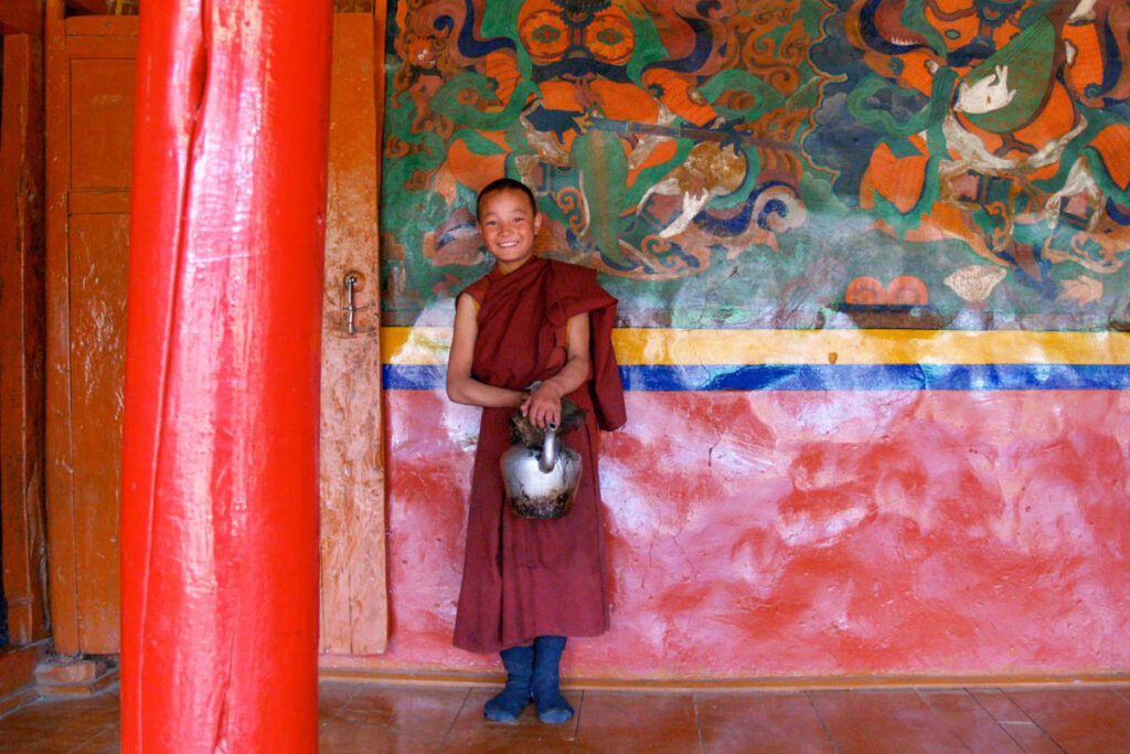
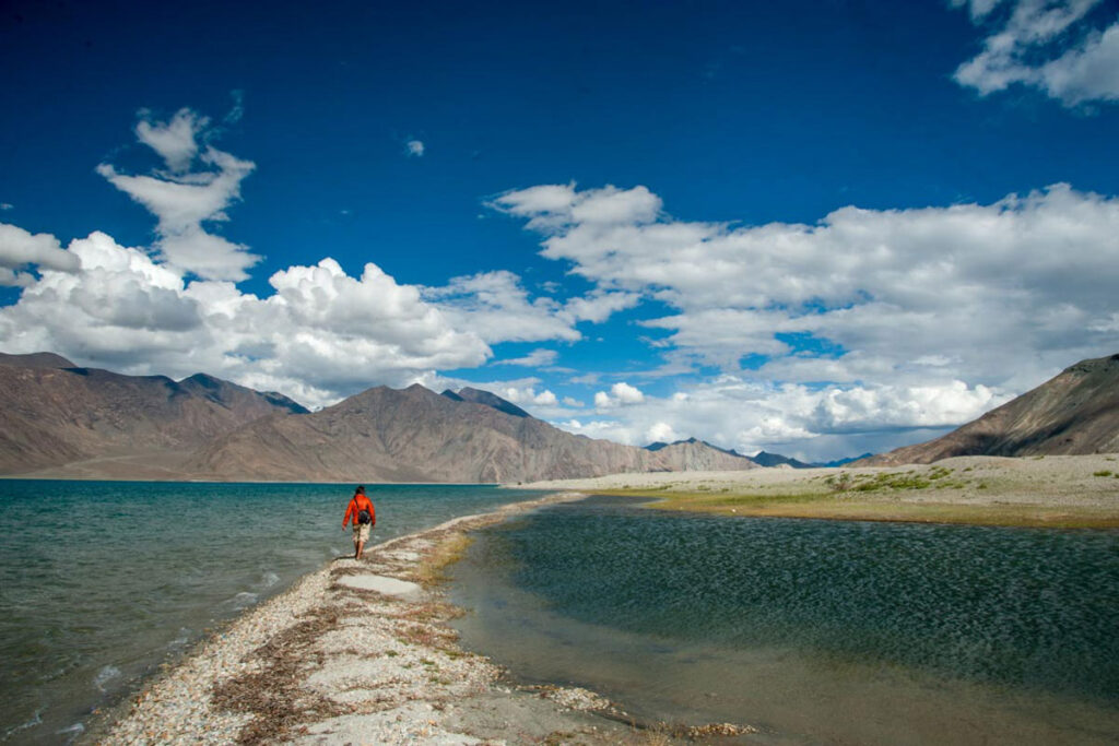
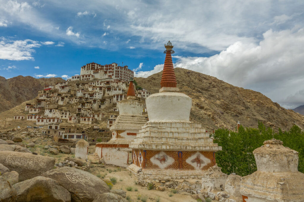
Ladakh & Zanskar
HP, Spiti, Lahaul & Kinnaur
HIMACHAL PRADESH
Himachal Pradesh
Himachal Pradesh (“Snow-laden Mountain Province”) is situated in the Western Himalayas, one of the thirteen mountain states, and is characterized by an extreme landscape featuring several peaks and extensive river systems. The state shares an international border to the east with the Tibet Autonomous Region in China. Himachal Pradesh is also known as Dev Bhoomi, meaning ‘Land of Gods’ and Veer Bhoomi which means ‘Land of the Brave’.
The predominantly mountainous region comprising the present-day Himachal Pradesh has been inhabited since pre-historic times, having witnessed multiple waves of human migrations from other areas. Through its history, the region was mostly ruled by local kingdoms, some of which accepted the suzerainty of larger empires. Prior to India’s independence from the British, Himachal comprised the hilly regions of the Punjab Province of British India. After independence, many of the hilly territories were organized as the Chief Commissioner’s province of Himachal Pradesh, which later became a Union Territory. In 1966, hilly areas of the neighbouring Punjab state were merged into Himachal and it was ultimately granted full statehood in 1971.
History
Tribes such as the Koli, Hali, Dagi, Dhaugri, Dasa, Khasa, Kanaura, and Kirata inhabited the region from the prehistoric era. The foothills of the modern state of Himachal Pradesh were inhabited by people from the Indus valley civilisation, which flourished between 2250 and 1750 BCE. The Kols and Mundas are believed to be the original inhabitants to the hills of present-day Himachal Pradesh, followed by the Bhotas and Kiratas.[21]
During the Vedic period, several small republics known as Janapada existed which were later conquered by the Gupta Empire. After a brief period of supremacy by King Harshavardhana, the region was divided into several local powers headed by chieftains, including some Rajput principalities. These kingdoms enjoyed a large degree of independence and were invaded by Delhi Sultanate several times.[21] Mahmud Ghaznavi conquered Kangra at the beginning of the 11th century. Timur and Sikander Lodi also marched through the lower hills of the state, captured several forts, and fought many battles. Several hill states acknowledged Mughal suzerainty and paid regular tribute to the Mughals.
The Kingdom of Gorkha conquered many kingdoms and came to power in Nepal in 1768. They consolidated their military power and began to expand their territory. Gradually, the Kingdom of Nepal annexed Sirmour and Shimla. Under the leadership of Amar Singh Thapa, the Nepali army laid siege to Kangra. They managed to defeat Sansar Chand Katoch, the ruler of Kangra, in 1806 with the help of many provincial chiefs. However, the Nepali army could not capture Kangra fort which came under Maharaja Ranjit Singh in 1809. After the defeat, they expanded towards the south of the state. However, Raja Ram Singh, Raja of Siba State, captured the fort of Siba from the remnants of Lahore Darbar in Samvat 1846, during the First Anglo-Sikh War.
They came into direct conflict with the British along the tarai belt, after which the British expelled them from the provinces of the Satluj. The British gradually emerged as the paramount power in the region. In the revolt of 1857, or first Indian war of independence, arising from several grievances against the British, the people of the hill states were not as politically active as were those in other parts of the country. They and their rulers, except Bushahr, remained more or less inactive. Some, including the rulers of Chamba, Bilaspur, Bhagal and Dhami, rendered help to the British government during the revolt.
The British territories came under the British Crown after Queen Victoria’s proclamation of 1858. The states of Chamba, Mandi and Bilaspur made good progress in many fields during the British rule. During World War I, virtually all rulers of the hill states remained loyal and contributed to the British war effort, both in the form of men and materials. Among these were the states of Kangra, Jaswan, Datarpur, Guler, Rajgarh, Nurpur, Chamba, Suket, Mandi, and Bilaspur.
Partition & Post- Independence
After independence, the Chief Commissioner’s Province of Himachal Pradesh was organized in 1948 as a result of the integration of 30 petty princely states (including feudal princes and zaildars) in the promontories of the western Himalayas. These were known as the Simla Hills States and four Punjab Southern Hill States under the Himachal Pradesh Order. The State of Bilaspur was merged into Himachal Pradesh in 1954. Himachal became a Part ‘C’ state in 1950 when the Constitution of India came into effect, and the Lieutenant Governor was appointed. Himachal Pradesh became a union territory in 1956. Some areas of the Punjab State, namely, Simla, Kangra, Kullu and Lahul and Spiti Districts were merged with Himachal Pradesh in 1966. The new state came into being in 1971.
Geography
The Zanskar Range runs in the northeastern part of the state and the Great Himalayan Range run through the eastern and northern parts, while the Dhauladhar and the Pir Panjal Ranges of the lesser Himalayas, and their valleys, form much of the core regions. The outer Himalayas, or the Shiwalik range, form southern and western Himachal Pradesh. At 6816m, Reo Purgyil is the highest mountain peak in the state of Himachal Pradesh.
The drainage system of Himachal is composed both of rivers and glaciers. Himalayan rivers crisscross the entire mountain chain. Himachal Pradesh provides water to both the Indus and Ganges basins. The drainage systems of the region are the Chandra Bhaga or the Chenab, the Ravi, the Beas, the Sutlej, and the Yamuna. These rivers are perennial and are fed by snow and rainfall. They are protected by an extensive cover of natural vegetation. Four of the five Punjab rivers flow through Himachal Pradesh, three of them originating in the state. These rivers run through a maze of valleys separated by the mountain ranges of the state. The Satluj Valley is formed by the Satluj river entering the state near Shipki La, while the Spiti and Baspa Valleys are formed by the river’s two major tributaries in the state. The Beas river flows though the Kullu and the Kangra Valleys, with tributary Parvati forming the Parvati Valley. The Chenab river, formed by the confluence of the Chandra and Bhaga, forms much of the northern regions of Lahaul and Pangi, and the Ravi river flows principally through Chamba. The Pabbar and Giri rivers in the southeast are part of the Yamuna basin.
Due to extreme variation in elevation, great variation occurs in the climatic conditions of Himachal Pradesh. The climate varies from hot and humid subtropical in the southern tracts to, with more elevation, cold, alpine, and glacial in the northern and eastern mountain ranges. The state’s winter capital, Dharamsala receives very heavy rainfall, while areas like Lahaul and Spiti are cold and almost rainless. Broadly, Himachal experiences three seasons: summer, winter, and rainy season. Summer lasts from mid-April until the end of June and most parts become very hot (except in the alpine zone which experiences a mild summer) with the average temperature ranging from 28 to 32 °C (82 to 90 °F). Winter lasts from late November until mid-March. Snowfall is common in alpine tracts. Pollution is affecting the climate of almost all the states of India. Due to steps taken by governments to prevent pollution, Himachal Pradesh has become the first smoke-free state in India which means cooking in the entire state is free of traditional chulhas.
Flora & Fauna
Himachal Pradesh lies in the Indian Himalayan Region, one of the richest reservoirs of biological diversity in the world. According to 2003 Forest Survey of India report, legally defined forest areas constitute 66.52% of the area of Himachal Pradesh. The state is endowed with a high diversity of medicinal and aromatic plants. Lahaul-Spiti region of the state, being a cold desert, supports unique plants of medicinal value.
Himachal is also said to be the fruit bowl of the country, with widespread orchards. Meadows and pastures are also seen clinging to steep slopes. After the winter season, the hillsides and orchards bloom with wild flowers, white gladiolas, carnations, marigolds, roses, chrysanthemums, tulips and lilies are carefully cultivated.
Himachal Pradesh has around 463 birds, and Tragopan melanocephalus is the state bird of Himanchal Pradesh, 77 mammalian, 44 reptile and 80 fish species. Himachal Pradesh has currently five National Parks. Great Himalayan National Park, oldest and largest National park in the state, is a UNESCO World Heritage Site. Pin Valley National Park, Inderkilla, Khirganga and Simbalbara are the other national parks. The state has 30 wildlife sanctuaries and 3 conservation reserves. The state bird of Himachal Pradesh is the Western tragopan, locally known as the jujurana. It is one of the rarest living pheasants in the world. The state animal is the snow leopard, which is even rarer to find than the jujurana.” – Wikipedia
SPITI & LAHAUL
“All foreign nationals require an inner line permit to visit the Spiti valley. Spiti is a high-altitude region of the Himalayas, located in the north-eastern part of the northern Indian state of Himachal Pradesh. The name “Spiti” means “The middle land”, or the land between Tibet and India. Others attribute the name to a Tibetan dacoit named Spiti Thakur. Based in Spiti valley, the Thakur gangs raided the upper parts of Kullu, before the Sen kings established their rule. The valley is surrounded on all sides by mountain ranges that separate it from former empires. These include Ladakh to the north, Tibet to the east, Bushahr to the south and Kullu to the west.
Spiti incorporates mainly the valley of the Spiti River, and the valleys of several rivers that feed into the Spiti River. Some of the prominent side-valleys in Spiti are the Pin valley and the Lingti valley. Spiti is bordered on the east by Tibet, on the north by Ladakh, on the west and southwest by Lahaul, on the south by Kullu, and on the southeast by Kinnaur. Spiti has a cold desert environment. The valley and its surrounding regions are among the least populated regions of India. The Bhoti-speaking local population follows Tibetan Buddhism. Traditionally, agriculture was for subsistence, but has shifted to cash crops in the past few decades. Spiti is a popular destination for photography, snow leopard spotting, and adventure tourism of various kinds, including winter sports.
Spiti (pronounced as ‘Piti’ in Bhoti language) is a high-altitude region of the Himalayas, located in the north-eastern part of the northern Indian state of Himachal Pradesh. The name “Spiti” means “The middle land”, the land between Tibet and India. Spiti incorporates mainly the valley of the Spiti River, and the valleys of several rivers that feed into the Spiti River. Some of the prominent side-valleys in Spiti are the Pin valley and the Lingti valley. Spiti is bordered on the east by Tibet, on the north by Ladakh, on the west and southwest by Lahaul, on the south by Kullu, Bushahr to the south, and on the southeast by Kinnaur. Spiti has a cold desert environment. The valley and its surrounding regions are among the least populated regions of India. The Bhoti-speaking local population follows Tibetan Buddhism. Spiti is a popular destination for photography, snow leopard spotting, and adventure tourism of various kinds, including winter sports.
There is evidence of very early human habitation in the Spiti valley, primarily through its rich heritage of pre-Buddhist Khasa rock art. Spiti’s rock art is thought to have been produced over a wide period of time, with the earliest examples dating back nearly 3,000 years. There is some evidence to show that Spiti was a part of the western Tibetan kingdom of Zhang Zhung until the mid-7th century. Buddhism first came to Spiti, likely through the Second Diffusion of Buddhism into Tibet, and it was at this time that the Tabo monastery was built, in 996. In the 10th century, Spiti was part of the kingdom of Ngari Khorsum, established by Kyide Nyimagon of the Tibetan royal lineage. After Kyide Nyimagon’s death, Zanskar and Spiti were given to his youngest son Detsukgon, while the eldest son Lhachen Palgyigon became the King of Ladakh. After that, the history of Spiti was linked with the history of Ladakh for a long time. Local rulers had the title of Nonos. They were either descendants of a native family of Spiti or chiefs sent to look after the affairs of Spiti by the rulers of Ladakh. This region became autonomous whenever the rulers of Ladakh were weak. However, the rulers of Spiti periodically sent tributes to Ladakh, Chamba and Kullu. Spiti became practically free after the Tibet–Ladakh–Mughal War of 1679–1683. This prompted Man Singh, Raja of Kullu, to invade Spiti and establish a loose control over this principality. Later on, in the 18th century, control once again passed back to Ladakh. An official was sent from Leh as Governor, but he usually went away after the harvest time, leaving the local administration in the hands of the Wazir or Nono. There was a headman for a group of villages for day-to-day administrative affairs. Spiti briefly came under the Dogra rule (as part of the Sikh Empire) between 1842 and 1846, after which it was annexed to the British Empire.
Under the Treaty of Amritsar in 1846, Spiti alongside Lahaul was split off from the erstwhile kingdom of Ladakh, and came under direct British administration. Mansukh Das, hereditary Wazir of Bushahr, was entrusted with the local administration of this region from 1846 to 1848. The Wazir had to pay the British revenue of 700 rupees annually for the whole of Spiti. In 1849, Spiti came directly under the control of the Assistant Commissioner, Kooloo (Kullu). Kullu was a sub-division of the Kangra district, of the Punjab Province. In 1873 the Nono of Kyuling village, near Kaza, was delegated the responsibility of collecting revenue from Spiti for the British, and was also given some judicial powers. In 1941, Spiti was made part of the Lahaul tehsil (sub-division) of Kullu district, with its headquarters at Keylong.
After the formation of Lahaul & Spiti into a district in 1960, Spiti was formed into a sub-division with its headquarter at Kaza. Lahaul & Spiti district was merged with Himachal Pradesh in 1966. The annexation of Tibet by the People’s Republic of China in 1951 turned Spiti into a sensitive region for the Indian government. Due to this, roads were built to Spiti over the 1950s-60s. By the 1970s, Spiti had road connectivity to Manali and Shimla.
The Spiti valley is located between the Kunzum range in the NW to Khab on the Sutlej river in Kinnaur in the SE. The Spiti River originates from the base of the 6118m K-111 peak. The Taktsi tributary flows out of the Nogpo-Topko glacier, near Kunzum La 150 km, the Spiti ends in the Satluj at Khab. The Pin, Lingti and Parachu as the major tributaries. The catchment area of the Spiti river is about 6300 km2. Situated in the rain shadow of the main Himalayan range, Spiti does not benefit from the South-West monsoon that causes widespread rain in most parts of India from June to September. The river attains peak discharge in late summers due to glacier melting.
There are two distinct parts of the Spiti valley. In the upper valley from Losar to Lingti, the river is braided with a very wide river bed, though the water channel is narrow. The valley floor has ancient sedimentary deposits, and the sides have extensive scree slopes. The lower valley runs from Lingti to Khab. Here, the meandering river has incised channels and gorges about 10–130m deep in the sedimentary deposits and bedrock. Tributaries and other streams join at right angles, indicating neotectonic activity in the past few million years.
Steep mountains rise to very high altitudes on either side of the Spiti River and its numerous tributaries. The highest peak in the Parung range to the NE has an altitude of 7030m and on the SW side, is Manirang Peak at 6598m. The mountains are barren and largely devoid of trees except for a few stunted willows and scattered trees in a some villages. The main settlements along the Spiti River and its tributaries are Kaza and Tabo.
Geology
Over millennia, the Spiti River and its tributaries such as the Pin River, have cut deep gorges in the uplifted sedimentary strata. As vegetation is sparse, the rock strata in the steep cliffs are easily visible to the geologist, without excavation or drilling. Thomson during his 1847 expedition noted three forms of alluvia in the Spiti valley. The first is deposits of fine clay. The second is triangular platforms that slope gently from the mountains to the river, usually ending in a steep cliff. The third are enormous masses of great depth, 120–180m above the river bed. The river has cut deep gorges through these platforms. The latter two consist of clay, pebbles and boulders. Thomson speculated that the valley appeared to have been a lake bed in the past though he could not conceive mechanisms to explain the phenomena. Now, we know that the valley was uplifted from the ocean bed due to the movement of tectonic plates. The Moravian geologist Ferdinand Stoliczka discovered a major geological formation near Mud village in Spiti in the 1860s. Stoliczka identified a number of layers or successions, one of which he named as the Muth succession.
Villagers in Spiti, especially those in higher villages like Komik, Kibber, Lhangza, claim that in recent decades, glaciers have been melting faster, and the quantity of snowfall has decreased. Villages in Spiti are dependent entirely on snowmelt water from winter snows and glaciers. Lesser snow and faster-melting glaciers endangers agriculture in the valley, which has only one agricultural season, being a high-altitude cold desert. Climate change is threatening the tradition of Gaddi shepherds’ annual migrations to Spiti with their herds of goat and sheep. It is degrading the quality of the pastures, and the ice bridges that Gaddis with their flocks could earlier use to cross rivers while bypassing villages are now disappearing. Scientific studies back up the ground-level observations that climate change due to global warming has been adversely affecting the environment of the Spiti valley.
The Tabo, Key, and Dhankar monasteries of Spiti belong to the Gelug school. The Kungri monastery, and nunneries in Mud village in the Pin valley belong to the Nyingma school. The Kaza and Komik monasteries belong to the Sakya School. In the recent decades, nunneries have been established at Kwang, Morang, Pangmo, and Kungri. The Pin Valley of Spiti is home to the few surviving Buchen Lamas of the Nyingma school. After Taklung Setrung Rinpoche, the head of the Nyingma sect and a noted scholar of the Tibetan Tantric school died on 24 December 2015, a search was started for his successor. In November 2022, the Nyingma sect located a boy in Rangrik village, Spiti who they believed to be the reincarnation of the late Rinpoche. The four-year old boy, Nawang Tashi Rapten, was born on 16 April 2018. On 28 November 2022, his head was tonsured to induct him into his new position and he started his formal religious education.
Traditionally, in Spiti, the society consisted of a hierarchy, with the Nonos (local aristocracy) at the top, the Chhazang (agriculturalists, practitioners of Tibetan medicine, and astrologers) in the middle, and the ‘pyi-pa’ (the separate endogamous groups of the ‘Zo’ blacksmiths and the ‘Beda’ musicians) at the bottom. Each of these groups tended to marry only among others of their own status. By custom, inheritance in Spiti has been through primogeniture, with the eldest son inheriting the estate. All younger sons would have to become monks. If the eldest son died, the younger brother would have to leave the monastery and become the husband to the widowed wife. This was a form of fraternal polyandry. Similarly, among women, by custom, only the eldest daughter would marry in earlier times. In some cases, younger daughters would become nuns. In others, they would stay at home either with their parents or the eldest brother, and were valuable additional work hands. In many cases, they died spinsters. Polyandry was prevalent until a few decades ago; its practice has almost disappeared now. Monogamy and nuclear families prevail nowadays.
Pin valley is renowned for the rearing of the rare Chumurti horse breed. Spiti is a summer home to many semi-nomadic Gaddi sheep and goat herders who bring their animals for grazing. They come to Spiti from neighbouring regions and sometimes from as far as 250 km (160 mi) away. They enter the valley during summer as the snow melts and leave just a few days before the first snowfall of the winter season.” – Wikipedia & AI
History (Ancient & Pre-Historical Periods)
Maharaja of Parmar Rajputs, had established Spiti valley, including settlement valleys in Lahaul, Spiti, and Tibet Autonomous Region. In 95 BC, invasions began which were unsuccessful even until 846 A.D. There is evidence of very early human habitation in the Spiti valley, primarily through its rich heritage of pre-Buddhist Khasa rock art. Spiti’s rock art is thought to have been produced over a wide period of time, with the earliest examples dating back nearly 3,000 years. Spiti’s rock art has been categorized, based on differences of the designs depicted, into the following periods: the Late Bronze Age (c.1500–800 BCE), the early Iron Age (c.800–500 BCE), the Iron Age (c.500–100 BCE), the Protohistoric period (100 BCE–650 CE), Early Historic Period (650–1000 CE), Vestigial Period (1000–1300 CE), and the Late Historical Period (post-1300 CE).
7th – 19th Centuries
There is some evidence to show that Spiti was a part of the western Tibetan kingdom of Zhang Zhung until the mid-7th century CE. Buddhism first came to Spiti, likely through the Second Diffusion of Buddhism into Tibet, and it was at this time that the Tabo monastery was built (996 CE).[6] In the 10th century, Spiti was part of the kingdom of Ngari Khorsum, established by Kyide Nyimagon of the Tibetan royal lineage.
After Kyide Nyimagon’s death, Zanskar and Spiti were given to his youngest son Detsukgon, while the eldest son Lhachen Palgyigon became the King of Ladakh. After that, the history of Spiti was linked with the history of Ladakh for a long time. Local rulers had the title of Nonos. They were either descendants of a native family of Spiti or chiefs sent to look after the affairs of Spiti by the rulers of Ladakh. This region became autonomous whenever the rulers of Ladakh were weak. However the rulers of Spiti periodically sent tributes to Ladakh, Chamba and Kullu
Spiti became practically free after the Tibet–Ladakh–Mughal War of 1679–1683. This prompted Man Singh, Raja of Kullu, to invade Spiti and establish a loose control over this principality. Later on, in the 18th century, control once again passed back to Ladakh. An official was sent from Leh as Governor, but he usually went away after the harvest time, leaving the local administration in the hands of the Wazir or Nono. There was a headman for a group of villages for day-to-day administrative affairs. Spiti briefly came under the Dogra rule (as part of the Sikh Empire) between 1842 and 1846, after which it was annexed to the British Empire.
Colonial Period
Under the Treaty of Amritsar (1846), Spiti alongside Lahaul was split off from the erstwhile kingdom of Ladakh, and came under direct British administration. Mansukh Das, hereditary Wazir of Bushahr, was entrusted with the local administration of this region from 1846 to 1848. The Wazir had to pay the British revenue of only Rs. 700 annually for the whole of Spiti. In 1849, Spiti came directly under the control of the Assistant Commissioner, Kooloo (Kullu). In 1873 the Nono of Kyuling village, near Kaza, was delegated the responsibility of collecting revenue from Spiti for the British, and was also given some judicial powers. In 1941, Spiti was made part of the Lahaul tehsil (sub-division) of Kullu district, with its headquarters at Keylong.The only built structure in Spiti which reflects colonial architecture is the Attargu suspension bridge, which was built in 1911 and formerly connected Spiti valley with Pin valley.
Post-Independence Period
After the formation of Lahaul and Spiti into a district in 1960, Spiti was formed into a sub-division with its headquarter at Kaza. Lahaul and Spiti district was merged with Himachal Pradesh in 1966.The annexation of Tibet by the People’s Republic of China in 1951 turned Spiti into a sensitive region for the Indian government. Due to this, roads were built to Spiti over the 1950s-60s. By the 1970s, Spiti had road connectivity to Manali and Shimla.
Geography
The Spiti valley is located between the Kunzum range in the NW to Khab on the Sutlej river in Kinnaur in the SE. The Spiti River originates from the base of the 6118 m K-111 peak. The Taktsi tributary flows out of the Nogpo-Topko glacier, near Kunzum La 150km, the Spiti ends in the Satluj at Khab. The Pin, Lingti and Parachu as the major tributaries. The catchment area of the Spiti river is about 6300 sq/km. There are two distinct parts of the Spiti valley. In the upper valley from Losar to Lingti, the river is braided with a very wide river bed, though the water channel is narrow. The valley floor has ancient sedimentary deposits, and the sides have extensive scree slopes. The lower valley runs from Lingti to Khab. Here, the meandering river has incised channels and gorges about 10–130m deep in the sedimentary deposits and bedrock. Tributaries and other streams join at right angles, indicating neotectonic activity in the past few million years.
Steep mountains rise to very high altitudes on either side of the Spiti River and its numerous tributaries. The highest peak in the Parung range to the NE has an altitude of 7,030 m (23,064 ft) and on the SW side, is Manirang Peak at 6598m. The mountains are barren and largely devoid of trees except for a few stunted willows and scattered trees in a some villages. The main settlements along the Spiti River and its tributaries are Kaza and Tabo.
Geology
Over millennia, the Spiti River and its tributaries such as the Pin River, have cut deep gorges in the uplifted sedimentary strata. As vegetation is sparse, the rock strata in the steep cliffs are easily visible to the geologist, without excavation or drilling. Thomson during his 1847 expedition noted three forms of alluvia in the Spiti valley. The first is deposits of fine clay. The second is triangular platforms that slope gently from the mountains to the river, usually ending in a steep cliff. The third are enormous masses of great depth, 120–180m above the river bed. The river has cut deep gorges through these platforms. The latter two consist of clay, pebbles and boulders. Thomson speculated that the valley appeared to have been a lake bed in the past though he could not conceive mechanisms to explain the phenomena. Now, we know that the valley was uplifted from the ocean bed due to the movement of tectonic plates. The Moravian geologist Ferdinand Stoliczka discovered a major geological formation near Mud village in Spiti in the 1860s. Stoliczka identified a number of layers or successions, one of which he named as the Muth succession.
Flora & Fauna
Spiti is a high altitude cold desert located above the tree line, with only a few stunted willows and scattered trees in some villages. There are shrubs on the valley floor. Despite this, Spiti boasts of more than 450 species of plants. These include seabuckthorn, ephedra, artemisia and other herbs. The alpine pastures on the high plateaus of Spiti are home to a variety of small bushes and grasses including rosa sericea, hipopheae, and lonicera. In terms of wildlife, the Spiti region is home to Himalayan ibex, snow leopard red fox, pika, Himalayan wolf, and weasels. The avifauna of the region includes the lammergeier, Himalayan griffon, golden eagle, chukar partridge, Himalayan snowcock and a host of rosefinches. Spiti is home to two protected areas, the Pin Valley National Park and the Kibber Wildlife Sanctuary.
Access
Spiti valley is accessible throughout the year via Kinnaur from Shimla on a difficult 412 km-long road. The Spiti subdivision of Lahaul and Spiti District starts at Sumdo (74 km from Kaza) which is quite near the India–China border. In summer Spiti can be reached via Manali through the Atal tunnel and Kunzum Pass. Kaza, the headquarters of the Spiti subdivision, is 201 km from Manali. The road joining Manali to Spiti is treacherous and in bad condition as compared to the Shimla to Spiti road. Due to the high altitude one is likely to feel altitude sickness in Spiti. The Shimla to Spiti route is advised for travelers coming from lower altitudes as it gives them enough time to get acclimatized to the high altitude. This is because the road runs parallel to the Sutlej river initially, climbing steadily to 2,550 m (8,370 ft) at the confluence of the Spiti and Satluj near Khab. From Khab, NH-505 runs along the Spiti River, climbing steeply up to Nako (3620m) before continuing to Kaza. NH-505 enters Lahaul at Kunzum La.
Religion
The local people of Spiti follow Tibetan Buddhism, and its culture is similar to those of its neighboring regions such as Tibet, Ladakh, and the Hangrang valley of Kinnaur district. The Gelug, Nyingma, and Sakya schools of Tibetan Buddhism have a presence in the Spiti valley. Each of these schools has monasteries in Spiti.
The Tabo, Key, and Dhankar monasteries of Spiti belong to the Gelug school. The Kungri monastery, and nunneries in Mud village in the Pin valley belong to the Nyingma school. The Kaza and Komik monasteries belong to the Sakya School. In the recent decades, nunneries have been established at Kwang, Morang, Pangmo, and Kungri. The Pin Valley of Spiti is home to the few surviving Buchen Lamas of the Nyingma school.[35] After Taklung Setrung Rinpoche, the head of the Nyingma sect and a noted scholar of the Tibetan Tantric school died on 24 December 2015, a search was started for his successor. In November 2022, the Nyingma sect located a boy in Rangrik village, Spiti who they believed to be the reincarnation of the late Rinpoche. The four-year old boy, Nawang Tashi Rapten, was born on 16 April 2018. On 28 November 2022, his head was tonsured to induct him into his new position and he started his formal religious education. Every village in Spiti has a small temple, or ‘Lhakhang’. A well-known Lakhang in Spiti is the ‘Serkhang’, or ‘Golden Temple’, at Lhalung village.
Social Organization
Traditionally, in Spiti, the society consisted of a hierarchy, with the Nonos (local aristocracy) at the top, the Chhazang (agriculturalists, practitioners of Tibetan medicine, and astrologers) in the middle, and the ‘pyi-pa’ (the separate endogamous groups of the ‘Zo’ blacksmiths and the ‘Beda’ musicians) at the bottom. Each of these groups tended to marry only among others of their own status. By custom, inheritance in Spiti has been through primogeniture, with the eldest son inheriting the estate. All younger sons would have to become monks. If the eldest son died, the younger brother would have to leave the monastery and become the husband to the widowed wife. This was a form of fraternal polyandry.[40] Similarly, among women, by custom, only the eldest daughter would marry in earlier times. In some cases, younger daughters would become nuns. In others, they would stay at home either with their parents or the eldest brother, and were valuable additional work hands. In many cases, they died spinsters. Polyandry was prevalent until a few decades ago; its practice has almost disappeared now. Monogamy and nuclear families prevail nowadays.
The entire local population of Spiti is categorized as a Scheduled Tribe by the Government of India. Nautor land rules have made it possible for those people to resort to law to get land, who by custom could not inherit and own land, just as in the neighboring district of Kinnaur.
Traditional Livelihoods
Agriculture in Spiti has traditionally revolved around the cultivation of barley, and some amount of black pea. In recent decades, these crops have been supplanted by green pea cultivation. Animal husbandry, particularly in higher parts of Spiti, revolves around yaks. Pin valley is renowned for the rearing of the rare Chumurti horse breed. Spiti is a summer home to many semi-nomadic Gaddi sheep and goat herders who bring their animals for grazing. They come to Spiti from neighboring regions and sometimes from as far as 250km away. They enter the valley during summer as the snow melts and leave just a few days before the first snowfall of the winter season. Performers of Spiti’s traditional dance in traditional dresses posing during the Ladarcha fair.
Festivals
Some significant local festivities in Spiti include the Guitor at Kyi Gonpa (July), Ladarcha fair (mid-August), Spiti Losar (around November), Thuckchu (winter solstice in December), Dachang (around February), and Sia Mentok (around February). All these festivals have been traditionally tied up with agricultural and seasonal shifts. The alcoholic beverages chhaang and arak are locally prepared and very popular, both in festivals and on various occasions like birth, marriage, the celebration of some success, and death.
Interesting Facts
Spiti was opened to tourism in 1992. Since 2016, this region has witnessed a tourism boom. Spiti was first photographed in the 1860s by Samuel Bourne, an early pioneer of photography in the Himalayas.Spiti was first filmed in 1933 by Eugenio Ghersi, a member of the Italian Tibetologist Giuseppe Tucci’s expedition to Spiti and Western Tibet. The narration of this 46 minute-long video is in Italian. Bollywood movies have also been filmed here. The climax episode of Rudyard Kipling’s novel Kim, first published as a book in 1901, is set in the Spiti valley. The Tibetan language film Milarepa, a biographical adventure tale about one of the most famous Tibetan Buddhist masters, was partly shot at the Dhankar Gompa and some other sites in the Spiti valley. Lonely Planet listed Lahaul and Spiti district as a whole, with specific mentions of both Lahaul and Spiti regions, among the ‘Top 10 regions’ in the world that were considered the best for travel over 2018, in an article published online on October 23, 2017. The National Geographic issue of July 2020 carried a long story on the snow leopards of Spiti, and the social, conservation, and tourism-related issues around them.
Agriculture
Cash-crop agriculture (of the green pea and apples), employment in state departments and development projects, and tourism are the main sources of income in the Spiti valley. Road accessibility has been of central importance to all these livelihoods and developmental activities. One crop per year is grown in Spiti. An administrator in 1871 reported that yaks were used for ploughing and the main crops were a fine hexagonal wheat, peas, mustard and two kinds of barley. As the Spiti river has eroded channels well below the valley floor, crops are irrigated using long channels winding along the terrain, often for many miles, to bring water from streams. The most important five crops have traditionally been black pea, potato, barley (2 varieties) and wheat, now diversified to include peas and apples. Road access has been noted as being vital to Spiti’s cash crop economy, as the harvest is almost entirely sold in distant markets in the north Indian plains. Interruptions in road access caused by landslides during the post-harvest season, which overlaps with the monsoon season, can adversely affect the pricing of Spiti’s cash crop produce.” – Wikipedia
LAHAUL
Lahaul
Lahaul was under the influence of the kingdom of Ladakh until the early 17th century, and the rulers of Chamba and Kullu vied for control over Lahaul in that period. In the 17th century, Lahaul came under the influence of the Rajas of Kullu, particularly under the reign of Raja Biddhi Singh (1672-1688) and his successor Raja Man Singh (1688-1719). In the early 19th century, Sikh forces captured Lahaul. After the Anglo-Sikh War of 1845-46, Lahaul came under the rule of the British Raj.
Colonial Period
Under British rule, Lahaul was made into a ‘waziri’ of the Kullu sub-division of the Kangra district of the Punjab Province. At that time, Lahaul had three ‘jagir kothis’ that pre-dated British rule: Kolong, Gumrang, and Gondhla. The heads of these ‘kothis’ (revenue districts) were hereditary ‘jagirdars’, and held the title of ‘Thakur’. The Thakur of the Kolong kothi was made the wazir for the whole of Lahaul by the British. M.S. Gill remarks that the wazir was a magistrate, police officer, jailer, revenue collector, and forest officer all rolled into one.
The first Thakur of Kolong to be given the designation of the ‘Wazir of Lahaul’ was Thakur Hari Chand, who held this post from 1877 until his death in 1900.The second Wazir of Lahaul was Thakur Amar Chand, who held this post over 1900-1921. He was the son of Thakur Hari Chand. Amar Chand was bestowed with the title of ‘Rai Bahadur’ by the British for his contributions to the British war effort in the First World War. The third Wazir of Lahaul was Thakur Mangal Chand (1886-1969). He was the younger brother of Thakur Amar Chand. Thakur Mangal Chand was the Wazir of Lahaul from 1921 until the time Thakur Pratap Chand (his nephew and a son of Thakur Amar Chand) achieved maturity. By the 1930s, Thakur Pratap Chand had become the fourth Wazir of Lahaul, and he would be the last.
Some sources note that the waziri was abolished in 1941. Lahaul and Spiti were then combined to form a sub-tehsil of Kullu, and Lahaul was administered by a Naib Tehsildar posted at Kyelang. However, Gill notes that the wazir was not formally displaced; only his powers were reduced. Overall, this system involving the Naib Tehsildar and the Wazir continued till 1960, when Lahaul and Spiti were combined to create the Lahaul and Spiti district.
Alongside agriculture and pastoralism, trade was an important occupation for Lahulis in the pre-Independence days. Alexander Diack noted in the late 19th century that at least one-third of the proprietors in Lahaul were engaged in trade. A major Central Asian trade route passed through Lahaul, connecting the plains of Punjab and the Kullu valley with Ladakh and Yarkand. Patseo, near Darcha (the last village in northern Lahaul) used to be the site of an important annual wool mart in the colonial period. It used to witness participation from traders and herders from Lahaul, Changthang, Tibet, Zangskar, Spiti, and Kullu, alongside Khampas and Gaddis. Many Lahauli would also annually go to Western Tibet to buy wool and pashmina for cash.
During the colonial period, Keylong had a Moravian mission, which ran from 1853 to 1940. Famous missionaries who served in Keylong included Heinrich August Jäschke, August Wilhelm Heyde, and August Hermann Francke. The Moravian missionaries did not have much success in building a Christian congregation in Lahaul. But they are remembered for introducing several crops (including potatoes, turnips, lettuce, spinach, and cauliflower), the practice of knitting, newspapers, kerosene stoves, and flue pipes to Lahaul.
Historical Sites
Some historical sites in Lahaul include the monastery and fort at Gondhla, Triloknath temple, Shashur Monastery, Khangsar Palace, and Mrikula Devi Temple.” – Wikipedia
POPULAR PLACES IN SPITI
Kunzum Pass
Losar
Chicham Bridge
Tabo Caves & Tabo Monastery
Dhankar Lake & Dhankar Monastery
Key Monastery
Kibber & Kibber Wildlife Sanctuary
Kaza
Mud
Pin Valley National Park
Gue Monastery
Hikkim & Komic villages
Demul village
Langza village & Budhha statue
Lhalung Monastery (Serkhang Monastery)
Mane Gogma & Mane Yogma villages
Chandra Taal
KINNAUR
Kinnaur & Hangrang
“The lower Spiti valley from the Sumdo bridge until the Spiti merges with the Sutlej river at Khab is called the Hangrang valley. Kinnaur district is a mountainous district located in the northeast part of the state of Himachal Pradesh, India. Kinnaur district borders Tibet (China) to the east, the state of Uttarakhand to the south, Shimla district to the southwest, Kullu district to the west, and Lahaul and Spiti district to the north. The administrative headquarters of the district is at Reckong Peo.
Over the 10th -11th centuries A.D., Kinnaur was a part of the Guge kingdom. The Guge kingdom broke apart in the 12th century, and the Bushahr state arose in the Western Himalayas, taking over most parts of present-day Kinnaur. The Bushahr state originated in the Kamru village of Sangla valley. However, the uppermost part of Kinnaur remained under Tibetan influence until the late 17th century, when it was handed over to the Bushahr state by the Tibetans as a reward for assistance in the Tibet-Ladakh-Mughal War. The Bushahr state shifted its capital to Sarahan, and later still to Rampur, which caused this state to be known eventually as ‘Rampur-Bushahr’. Rampur-Bushahr was attacked by the Gurkhas in the early 19th century. Soon afterwards, the British gained supremacy in the region. Rampur-Bushahr became a princely state owing suzerainty to the British crown, until India’s Independence in 1947. Most of present-day Kinnaur district was known as ‘Chini tehsil’ under the Rampur-Bushahr state. On 15 April, 1948, Rampur-Bushahr became a part of the Republic of India, and a part of an administrative unit called the Mahasu district. In 1960, the Chini tehsil and fourteen villages of the neighbouring Rampur tehsil were separated from the Mahasu district to create the new district of Kinnaur. Most of Kinnaur has a temperate climate, due to its high elevation. The upper areas of the Sutlej valley and an adjoining lower part of the Spiti valley (which also falls under the Kinnaur district) lie in the rain shadow area, with an arid climate similar to Tibet. In this region, winters are long and harsh, with snowfall, while summers are mild. The lower parts of the Sutlej valley and the Baspa valley receive monsoon rains over July to September. The rains vary from moderate to heavy, making some areas prone to landslides. Portions of Kinnaur are situated high in the Himalaya, where vegetation is sparse and consists primarily of hardy grasses. Alpine species such as juniper, pine, fir, cypress, and rhododendron can be found at elevations between 3500 and 5000m, primarily in Middle Kinnaur. At lower altitudes, temperate-climate trees are found, including oak, chestnut, maple, birch, alder, magnolia, apple, and apricot.” – Wikipedia & AI
MONASTERIES & SITES
Keylong
“Kyelang (Keylong) is a town and the administrative center of the Lahaul & Spiti district in Himachal Pradesh, 71km north of Manali via Atal Tunnel, and 120 km from the Indo-Tibetan border. While it used to take 4 to 6 hours to ascend, negotiate, and descend the Rohtang pass, it will take only about 15 minutes to travel through the Atal tunnel. Keylong is located along the Manali-Leh Highway and the banks of the Bhaga River, about 7 km northeast of where the Chenab Valley splits into the Chandra Valley and Bhaga Valley. Kyelang has a subalpine climate, bordering upon an alpine climate, with frigid, snowy winters and cool summers. As it lies south of the main Himalaya range, snowfall is much heavier than in arid Spiti or Ladakh. Sights near Kyeoang include the Kardang, Shasur, and Tayul Monasteries, all within a few km of Kyelong. There is also a small temple dedicated to the local deity Kelang Wazir in the house of Shri Nawang Dorje that may be visited upon arrangement. The annual Lahaul Festival is held here each July with a big, busy market and a number of cultural activities. Kyelang faces the famous Kardang Monastery, the largest and most important monastery in Lahaul, of the Drukpa sect of Tibetan Buddhism, which is on a slope across the river from Keylong.
Kardang Monastery 3500m
Kardang Monastery or Gompa is a famous Drukpa Lineage monastery, and is the most important monastery in the Lahaul valley, India. The associated village of Kardang was once the capital of Lahaul. The monastery is a huge white building bedecked with prayer flags[2] It is situated on a ridge below the 4572m Rangcha Peak on the left bank of the Bhaga River, facing the town of Keylong, about 8 km away. Kardang is connected by the road via the Tandi Bridge, 14 km from Keylong. The monastery was featured on the 7 November 2010 episode of the History Channel TV series IRT Deadliest Roads, where trucker Rick Yemm delivered a large golden Buddha statue to the monastery and was greeted by the monastery’s head, Lama Paljor Larje.
History
The monastery is believed to have been built in the 12th century and houses a large library of Buddhist literature, including the Kangyur and Tangyur scriptures in the Bhotia language. There is also a good collection of fine thankas, musical instruments such as lutes, drums, horns, as well as old weapons. There are colourful frescoes and murals. The monastery was in ruins until it was renovated in 1912 CE by Lama Norbu Rinpoche.
In the first room is a 1.23m high silver chaitya or chorten preserving the skull and ashes of Lama Norbu. To the right of it are statues of Padmasambhava and Tara (Devi), and in the back, one of Tagden Shakyashree, guru of Lama Kunga. 103 volumes of the Kangyur are kept here, while behind are 64 tantra books on various subjects. The second room is the main Prayer Hall with an eleven-headed statue of Avalokitesvara. On a high pedestal at the right are some of Lama Norbu’s castoff garments and with a skull in front. In the third room is a six-foot wooden prayer wheel with a brass bell on it. There are now about thirty monks and nuns (chomos) in the monastery, and two British nuns have studied, meditated, and been initiated in recent years.
The monks and nuns have equal rights, and the monks have permission to marry. The monks spend the summer with their families working their fields, in the winter they return to the monastery. There is a huge prayer drum in the monastery with the sacred six-syllable mantra, Om mani padme hum, written a million times on strips of paper. It also has a Narbo as its head lama.
Because the monastery is on the southern bank of the Bhaga River, it gets very little sun, while Keylong on the opposite side gets far more as it is facing south. Because of this the Moravian Christian mission, which was established here in 1857, was later moved across the river to Keylong.” – Wikipedia
Rampur Bushahr
“Rampur Bushahr, in the Shimla district of Himachal Pradesh (130 km from Shimla). The principality of Bushahr (also known as Bashahar, Bushahar, Bashahr) was once among the largest of the twenty-eight Shimla Hill States under the administration of the British Raj keen to invest on regional and transcontinental trade and exploit Himalayan resources. Caught in one of the British imperial enterprise, it was subjected to political-cum-economic vicissitudes, acceding to the Indian Union in 1947. On 8 March 1948, along with twenty other princely hill States of Punjab and Shimla, Bashahr signed an agreement which resulted in its inclusion in the Indian State of Himachal Pradesh.
Rampur, a small township on the left bank of the Sutlej, served as Bushahar’s winter capital. Being well connected with major trading routes that joined Indian markets with Central Asia and Tibet, it buzzed with mercantile activity, especially in November during the Lavi fair, the largest trading event in the north Himalayas attracting traders from Kashmir, Ladakh, Yarkand, and the Indian mainland. Concerning the origins of the Rampuri fair, the Census of India (1961) reports:
“About three hundred years ago during the regime of Raja Kehar Singh of Bushahr, a trade treaty was signed between the Bushahr State and Tibet…Horses from Tibet and swords from Bushahr were exchanged in token of this friendship. It was written in the treaty that their friendly relations would continue till this time…Since then, it is presumed that trade relations increased and eventually [the] Lavi fair was held.”
Rampur was also located along pilgrimage routes to sacred sites in western Tibet shared by Hindus, Bön and Buddhists alike, i.e., Mount Kailash and Lake Mansarovar. Missionary and pilgrimage activities, intensified by trading possibilities, created the conditions for Tibetan Buddhism to take a firm stronghold in these borderland regions. Twenty-two kilometres from the village of Namgya in upper Kinnaur, laid the Shipki pass which linked caravan routes to and from western Tibet. This treacherous transcontinental passage must have been in use from ancient times, for among the ruined castles reported by Francke at Shipki village, there were no living memories of the origins of mKar gog, the oldest of them built above the village in cyclopean style. Rampur also has Hydro Power Stations namely, Nathpa Jhakri Power Station (1500 MW) and Rampur Hydro Power Station (412 MW) by SJVN Ltd. A second castle, known as Seng ge mkhar, is said to have received its crooked ground plan “through a race round its base executed in opposite directions by a poisonous snake and a scorpion,” and was built, in all probability, during the Ladakhi occupation of mNga’ ris by orders of King Seng ge rnam rgyal (1570–1642) and called after him.
Rampur is located at 31.45°N 77.63°E.[3] It has an average elevation of 1021m. It is a very beautiful place situated at the bank of the Satluj river. It borders on the north with Nirmand, on the west with Kumarsain and Anni, on the east with Kinnaur and on the south with Rohru. The city is nearby to popular places like Jhakri, Sarahan Bushahr, Green valley Bara Bish and Shraikoti to name a few. The city is also the home to Asia’s Largest underground Hydro Power Project – The Nathpa Jhakri Hydro Power Station built by Satluj Jal Vidyut Nigam Ltd (formerly known as Nathpa Jhakri Power Corporation) at Jhakri with dam sight at nathpa in Kinnaur and world’s deepest Surge shaft at a Shah (22 km from Rampur).”
Rekong Peo (Reckong Peo)
“Rekong Pe, is headquarters of Kinnaur district, one of the twelve administrative districts of the Indian state of Himachal Pradesh (260km from Shimla). Earlier Kalpa was the headquarter of the Kinnaur district administration. It was later shifted down to Reckong Peo. The place is named after a group of people who used to own this place in ancient times. Reckong Peo serves as a base for the pilgrims who go for an annual three days trek to an 80 feet high holy rock pillar that is considered to be as Lord Shiv or ‘Shivalinga’. Whereas a clockwise ‘Parikrama’ (circumambulation) trek around the holy rock start from Charang village and end at Chitkul after traversing a long and challenging terrain. Apple orchards are found in abundance due to favorable climatic conditions. Houses are built traditionally that depict the culture and lifestyle of Himachal Pradesh. Reckong Peo is the commercial and administrative center of the Kinnaur district as the biggest market of the entire district is located here and all important governmental as well as administrative offices are located at Reckong Peo. Places of interest are Bodh Mandir (Buddhist Temple), Durga Mata Temple, Kothi, Khawangi Temple, Telangi, Dakho viewpoints. The primary attractions of Recong Peo are the Chandi Mata Temple and Bhabha Valley.” – Wikipedia
Nako
“Nako is the largest village in the Hangrang Valley. It is set against the scenic backdrop of Reo Purgyal (6816m), the highest mountain in Himachal Pradesh. Nako Monastery, dated to 1025, is located in the village as well as several other Buddhist chortens. One of the earliest descriptions of Nako is by the botanist Thomas Thomson based on his expedition in August 1847. He reported that Nako was smaller than Peo. He and his team were accommodated in apartments in the Buddhist monastery. There was an abundance of water and extensive cultivation, a copse of poplars and willows, but no fruit trees. Nako Lake is a prominent feature here where it borders the village.
Nako Monastery
Nako Monastery dates from the 11th century, and is similar in style to Tabo Monastery, consisting of four large halls of which the oldest and largest is known as the dukhong. It is also known as ‘Lotsava Jhakang’ meaning “complex of the translator” named so in honor of Rinchen Zangpo who translated Buddhist scriptures from Sanskrit to the Tibetan language. The iconographic art work in the monastery is related to Vajrayana Buddhism. The dukhong’s walls have decorations of a complete mandala with “gates, fire-circle and secondary non-Buddhist deities in attendance”. To the east of this dukhong there is another hall of smaller size which has a sculpture of Yellow Tara (known as Grolgster) made in stucco, with its roof and walls painted with mandalas. In the third hall there is an elegant image of Vairochana. Within the complex there is a shrine dedicated to Purgyal, a local deity with attribution as the “spirit of the mountain”. Sculptures of five Dhyani Buddhas made out of clay are defied in the main hall where there are also many images
In the earthquake of 1975 the buildings were affected. Many bright artworks in the monastery were vandalized. During this earthquake event roofs of the monastery and other buildings in the village were damaged. Further, during the severe winter season of 1998 the monastery was in near collapse stage. Following these disastrous events, in May 1998, the University of Vienna launched a research Project in association with the Indian National Trust for Art and Cultural Heritage (INTACH), the Buddhist Association of Nako, and local residents of Nako to carry out restoration works. In July 2002, the Nako Preservation Project (NPP) came to be established for conservation of the monastery and other buildings in Nako.
Nako Lake 3636m
Nako Lake, a small lake in the Kinnaur district, on the slopes of the Reo Purgyal mountain of the Srikhand range. During the evening twilight hours a very large number of birds flock the lake. There is a rock here which is believed to have the foot print of Padmasambhava recording his visit to the area. A shrine has been built around this foot print and there is also stucco statue of Padmasambhava above it in addition to murals. The periphery of the lake has plantations of willow and poplar trees. The lake has boating facilities during the summer months and ice skating is practiced on the lake’s surface which gets frozen during the winter months.
Chango Gompa
A few km away from Nako Monastery on the road from Spiti, has a prayer wheel more than 500 years old, which measures about 3.5 m (11 ft) in diameter and made of yak skin.”
Pooh (Poh)
“Poo, or Pooh, also known as Spuwa is a small town in the Kinnaur district known for its natural environment, green fields, apricot orchards, vineyards and almond trees. Inscriptions suggest that Poo was an important trading center in the early 11th century. When A. H. Francke arrived in Poo from the south in July, 1910, it was the first village he found where the language was “entirely Tibetan”. In Pooh, there is an ancient temple, the Lotsaba-bai-lha-khang, dedicated to Shakyamuni or Buddha and attributed to the translator (or Lotsaba), Rinchen Zangpo (958–1055). The shrine has wooden columns supporting a high ceiling. It has murals and a painted door from the period of Rinchen Zangpo (10th – 11th c), although they are in a poor state of preservation. There is a local pre-Buddhist deity, Dablā, who has no dwelling or altar in Poo (although he has a devata temple devoted to him at Kanum). His only manifestation is a pole with a small idol set on its upper portion and adorned with yak tail hair and long pieces of colored cloth.” – Wikipedia
Tabo
“Tabo is a small town in the Lahaul & Spiti district, situated on the banks of the Spiti River between Rekong Peo and Kaza. The town surrounds a Buddhist monastery which, according to legend, is said to be over a thousand years old. The Dalai Lama has expressed his desire to retire to Tabo, since he maintains that the Tabo Monastery is one of the holiest. In 1996, the Dalai Lama conducted the Kalachakra initiation ceremony in Tabo, which coincided with the millennium anniversary celebrations of the Tabo monastery. The ceremony was attended by thousands of Buddhists from across the world. Tabo Monastery’s spiritual head is Tsenshap Serkong Rinpoche.
Tabo Monastery
Founded in 996 CE by the Tibetan Buddhist Lotsawa (translator) Rinchen Zangpo (Mahauru Ramabhadra), on behalf of the king of western Himalayan Kingdom of Guge, Yeshe-Ö. Tabo is noted for being the oldest continuously operating Buddhist enclave in both India and the Himalayas. A large number of frescoes displayed on its walls depict tales from the Buddhist pantheon. There are many priceless collections of thankas (scroll paintings), manuscripts, well-preserved statues, frescos and extensive murals which cover almost every wall. The monastery is in need of refurbishing as the wooden structures are aging and the thanka scroll paintings are fading. After the earthquake of 1975, the monastery was rebuilt, and in 1983 a new Du-kang or Assembly Hall was constructed. It is here that the 14th Dalai Lama held the Kalachakra ceremonies in 1983 and 1996. The monastery is protected by the Archaeological Survey of India (ASI) as a national historic treasure of India.
The monastery was built by the Buddhist king (also known as Royal Lama) Yeshe-Ö in 996 A.D. It was renovated 46 years later by the royal priest Jangchub O’d, the grandnephew of Yeshe-Ö. They were kings of the Purang-Guge kingdom whose ancestry is traced to the ancient Tibetan monarchy, and extended their kingdom from Ladakh to Mustang by building a large network of trade routes, and built temples along the route. Tabo was built as a ‘daughter’ monastery of the Tholing Monastery in Ngari, western Tibet. This royal dynasty was instrumental in re-introducing the Indian Mahayana Buddhism in Tibet, the second major spreading of Buddhism in Tibetan history. They contributed richly to the political, religious and economic institutions of Tibet in the 11th century through the building of Tabo Monastery; this is documented in the writing on the walls of Tabo.
The iconographic depictions are reported to be of 1042 and later, consisting of paintings, sculptures, inscriptions and extensive wall texts. The translator Rinchen Zangpo, a Tibetan lama from western Tibet, who was chiefly responsible for translating Sanskrit Buddhist texts into Tibetan, was the preceptor to King Yeshe-Ö who helped in the missionary activities. Several Indian pundits visited Tabo to learn the Tibetan language.
The monastery has been built like a fort with very strong walls. The walls of these structures are .91m thick, the reason for its survival over the centuries of depredations and natural calamities. The high mud brick wall which encloses some 6,300 sq/m. In addition to the temples, chortens, and monks’ residence, there is an extension that houses the nuns’ residence. Daily worship starts with chantings at 6 AM, performed by the lamas who live in the new temple complex. The lamas also perform tantric rites here in the temples.
17th – 19th Centuries
During the 17th-19th centuries, the monastery and the bridge across the Spiti River witnessed historical events and political turmoil in the area. Manuscripts such as Tabo Kanjur make mention of some violent confrontations. An inscription of 1837 records attacks on the Tabo Assembly Hall in 1837, which can also visually be seen by damages to some parts of the walls. The attack is attributed to ‘Rinjeet’s troops’ who were under the kings of Ladakh. With the British Rule from 1846, the area enjoyed peace until the 1950s when the Indo-China border disputes reawakened the political claims of the border posts. In 1855, Tabo had 32 monks.
Modern Era
The original monastery was severely damaged in the 1975 Kinnaur earthquake. Subsequent to its full restoration and the addition of new structures, the 14th Dalai Lama visited the monastery and initiated the Kalachakra Festival (a process of initiation and rejuvenation) in 1983, after the Kalachakra Temple was built. He also revisited in 1996 when the millennium of its existence was celebrated and has returned on numerous occasions. In 2009, the Dalai Lama was scheduled to inaugurate the Kalachakra Stupa, which has been built as an auspicious symbol, following the special blessings of Kalachakra he had performed earlier. Sakya Trizin and other Tibetan teachers and meditation masters have also visited the monastery and encouraged the Buddhist practice among the local people.
The monastery has 45 monks. Kyabje Serkong Tsenshap Rinpoche (1914-1983) served as the Head Lama prior to Geshe Sonam Wangdui, who became the Abbot of Tabo Monastery since 1975. His responsibilities include caring for the monastery and monks, teaching Buddhist scripture, and looking after the local community. Current Serkong Tsenshap Rinpoche is the spiritual head of the monastery. Tabo is protected by the ASI as a national historic treasure of India.
Tabo Monastery (Tabo ‘Chos-hKhor’ or Doctrinal Enclave) now has nine temples, four decorated stupas, and cave shrines. The paintings date to the 10th-11th centuries for main temple (Tsug la Khang), 13th-14th centuries for the stupas, and from the 15th to the 20th centuries for all the other temples. Yeshe-Ö and his two sons when they built the monastery in 996 AD blended the provincial and regional characteristics with that of India and Central Asia. One particular feature mentioned in this regard is the iconographic themes of non-Buddhist traditions emanating from the protectress deity Wi-nyu-myin. The main temple is conjectured to represent the entire Vajradhatu Mandala.The monastery has a huge collection of manuscripts and Pramana texts, which were filmed between 1991 and 1998.
Main Temple
The main temple has an entry hall (Go Khang), followed by an Assembly Hall (Du Khang). At the western end of the assembly hall there is an apse (recessed area), which has a cella or shrine area (Ti Tsang Khang) with an ambulatory (Kor lam Khang) passage. The entry hall has pictures of Yeshe-Ö and his two sons Nagaraja and Devaraja, the founders of the temple, on its south wall. The temple has a new entry hall (Go Khang), which has paintings dated to the late 19th century or 20th century. The old entry hall, which originally formed the only part of the complex, has retained the paintings of 996 AD.
The Vajradhatu mandala is seen in the New Assembly Hall after entering from the old entry hall where the main deity of Vajradhatu, Vairocana (height 110 cm), is shown seated on a single lotus throne on the back wall. The main iconographic deities here are the Vajradhatu and life-size clay sculptures with painted decorations complementing the main theme. The mandala also has 32 life-size clay sculptures of other deities which are embedded to the wall which merge well within the painted environment. The Protector Deity, Dorje Chenmo, originally known as Wi-nyu-nin, of the main temple was venerated in this hall. The paintings are of very good quality with bright colours, and are dated to 15th or early 16th century. An inscription which brings out the details of renovation works done is fixed to the right of Vajrapasa image. The paintings are depicted in three sections with the central panel of the throne scene. The royal lama, Jangchub ‘Od, who was in charge of the renovation, is painted here. On the left part of the composition ‘the great Sangha of Tabo monastery’ is depicted.
Three very large life-size sculptures are located on a raised platform. They are within the shrine area of the temple. Each is flanked by a pair of painted goddesses. A seated Buddha figure sitting on a throne with the base sculpted with two lions facing each other is also seen; this is a partially restored image. The circumambulation of the temple performed by the devotees in a clock-wise fashion passes through the assembly hall. During this process, the narrative imagery on the south and adjacent walls, the pilgrimage of Sudhana, and on the north and adjacent walls, the Life of the Buddha are seen.
The main temple (Tsug la Khang) has the main hall and main assembly area. It also contains many scriptures written on wooden planks, which are hung on the walls. The dark main temple room is lit by a small sky window and hence the room appears dark. In the inner vestibule, there are colorful frescoes of Buddhist and Hindu-Buddhist gods. Next to the vestibule is the small room where garments for the ritual dances are kept. The main hall at the centre is studded with images, and at the centre is a Buddha image in the Lotus position. This image is flanked on either side by divine figures. On the pedestals next to the main image are many more brass images of Lamas. Tapestries cover the walls, doors and columns, and paintings of various Buddha incarnations, starting with Siddhartha and that of the Panchen Lamas, give it a divine atmosphere. About 50 clay images and full size busts of gods and demons are seen in the back wall of the main hall. The 108 holy scriptures are also part of the main hall display and weigh about 500 pounds.
Older Temples
The Golden Temple is said to have been once covered with gold. It was renovated by Sengge Namgyal, a king of Ladakh in the 16th century. The walls and ceilings are covered with magnificent murals, which are well preserved and are dated to the 16th century. The other iconographic figures seen here are also found in other temples within the complex, and one such is of Vajradhara depiction.
The Bodhisattva Maitreya Temple (Byams-Pa Chen-po Lha-khang) is an ancient temple built in the first 100 years of the main monastery as testified by the wooden door frame. Remnants of a painting is attributed to the 14th century. According to the sketch in the Mandala Temple it is indicated that the Maitreya Temple was initially double storied, which is also confirmed by the damage to the entrance wall. The image of the Bodhisattva Maitreya here is over 6m high. There are also murals showing Tashilhunpo Monastery in Shigatse and the Potala in Lhasa. A carved stone column base has the figure of a lion.
In the Initiation Temple, there is a huge painting of Vairocana surrounded by eight Bodhisattvas. The other walls are covered in mandalas. This is where monks receive their initiations.
The Temple of Dromton or Trom-ton is thought to have been founded by Dromton (1008-1064 CE), one of the main disciples of Atisha. The Large Trom-ton Temple has murals of the eight Medicine Buddhas, which are dated to the 17th century; at the base of this temple the life of Shakyamuni Buddha is painted in a narrative form. The Small Mandala Temple is used for tantric rituals and teachings, may also be of the early period. The interior of the Small Trom-ton Temple has very elegant paintings; however, remnants of carvings, dates attributed to the 13th or 14th century, are discerned at the entry door to the temple. The Nun’s Temple, a small temple, is seen on the back wall of the compound; the paintings here dated to 18th century are not of good quality.
Newer Temples
Five temples are included in the newer temple group, such as the Chamber of Picture Treasures and the White Temple. After the assembly hall, the large Temple of Dromton (Brom-ston Lha khang) is the largest temple in the complex and contains many wall paintings; the wooden planks in the ceiling are decorated. The Mahakala Vajra Bhairava Temple (Gon-khang) contains the protective deity of the Gelukpa sect; it contains fierce deities and is only entered after protective meditation. The Protectress deity of the monastery along with her retinue are depicted on a large panel on the east wall of the main entrance; this painting was damaged due to water seepage and has been very well restored by ASI as it provides a link to the old history of Tabo Monastery.
The monastery is known as “the Ajanta of the Himalayas” because of its frescoes and stucco paintings. The iconography of this period in the temples also supports the bond that existed between the two cultures of India and Tibet. There is a large and priceless collection of thankas (scroll paintings), manuscripts, well-preserved statues, frescos and extensive murals which cover almost every wall. While in the earlier period, paintings in the interior of the main Tabo temple and its stupas represented the Nyingmapa, Kadampa and Sakyapa traditions, the later period represent paintings of the Gelugpa tradition. In the independent small chambers of the monastery, there are many paintings on the walls. The frescoes seen inside the gompa are in a fragile state. Some are of a bright cobalt colour. Prior to the 1975 earthquake, there were 32 raised medallions on the walls of the temple hall, and an image placed in front of each of them.
Education
Tabo evolved as an important centre of learning in its early centuries; the Kadampa School developed into the Gelugpa School. The monastery currently runs the Serkong School, established in 1999. There are 274 students, from the age of 5 to 14 years, in classes 1–8. The subjects covered are English, Hindi and Spiti Bhoti languages, Social Science, Social Studies, Math and General Knowledge. Information technology, Sanskrit language and Art are also provided to students in higher grade levels. The Indian government funds about 50 per cent of the school through a grant; the rest of the expenses are met through student fees and donations. The monastery has plans to enlarge the school’s infrastructure and facilities but needs funding.
Many festivals are held in the precincts of the monastery. The Tibetan monks perform traditional Buddhist and regional songs and dances. The most popular religious festival held here is the Chakhar Festival, which is dedicated to the peace and happiness of all. This is held every three years, usually during September or October. On this occasion, religious masked dances, songs and general festivities are the main events.” – Wikipedia
Kaza
Kaza (Kaze, Karze, Karzey), situated along the Spiti River, is in the Lahaul and Spiti district, a high altitude or cold desert having close similarities to neighboring Tibet and Ladakh in terms of terrain, climate and Buddhist culture. Kaza, one of the coldest towns in India, is the largest township and commercial center of the Spiti valley. The town is divided into the old, as Kaza Khas and new as Kaza Soma sections. The new town contains the administrative buildings. Approaching Kaza from the south, one sees Kyu-ling, the stately palace of the Nono (king) on the other side of the river. The Tangyud Gompa of village Komik dates to the early 14th century and is built like a fortified castle with massive slanted mud walls and battlements with vertical red ochre and white vertical stripes. It is located on the edge of a deep canyon, overlooking Kaza, 4 km from town. Kaza is known for its colorful festivals and the ruins of the ancient Sakya Tangyud Monastery, located near village Komik, 14km from Kaza. The highest post office in the world at Hikkim village (PIN 172114) at an elevation of 4400 m is situated 46 km (29 mi) from Kaza. It sends postal letters to and receives postal articles from Kaza post office.
Festivals
The prominent festivals celebrated in Kaza are Ladarcha (mid-August), Spiti Losar (around November), and Dachang (around February). The Ladarcha fair is the largest annual event in all of Spiti. In earlier times, it used to be a multi-day trade fair held annually in July at the Ladarcha ground near Chichim village in upper Spiti. It used to witness barter trade among locals of Spiti and traders from Ladakh, Bushahr princely state, Tibet, and Kullu. The old trade fair ended following the Sino-Indian war of 1962. The fair was revived by the Himachal Pradesh government in the 1980s. The location of the revived fair, now primarily a cultural event, was shifted from the Ladarcha ground near Chichim to Kaza. In recent decades, the Ladarcha fair has been held every year in August, typically in its third week, right after Independence Day
Sakya Monastery
Sakya Tangyud Monastery was built in 2009, Key (Ki) Monastery was built by Dromton, a student of the renowned instructor, Atisha, in the eleventh century and is located at a height of 4166m north of Kaza town.
Ladakh & Zanskar Information
“The center of Leh is a wide bazaar where much polo is played in the afternoons; and above this the many irregular flat-roofed, many-balconied houses cluster around the palace and a gigantic chorten alongside it. The rugged crest of the rock on a spur of which the palace stands is crowned by the fantastic buildings of an ancient gonpa … a very mixed population in which the Moslem element is always increasing … partly due to the marriage of Moslem traders with Ladakhi women who embrace the faith of their husbands.
Great caravans en route for Khotan, Yarkand and even Chinese Tibet arrived daily from Kashmir, the Punjab and Afganistan, and stacked their bales of goods in the place. The Lhasa traders opened shops in which the specialties were brick tea and instruments of worship. Merchants from Amritsar, Kabul, Bokhara and Yarkand … thronged the bazaar and opened bales of costly goods in tantalizing fashion. Mules, asses, horses and yaks kicked, squealed and bellowed; the dissonance of bargaining tongues rose high. There were mendicant monks, Indian fakirs, Moslem dervished, Mecca pilgrims, itinerant musicians, and Buddhist ballad howlers. Broad-faced women with creels on their backs brought in lucerne, Ladakhis, Baltis and Lahaulis tended the beasts
… Lhasa traders in heavy winter clothing exchange their expensive teas for Nubra and Baltistan dried apricots, Kashmir saffron and rich stuffs from India. Merchants from Yarkand on big Turkestan horses offer hemp, which is smoked as opium, and Russian triffles and dress goods, under cloudless skies. With the huge Kailas (Karakorum) range as a background, this great rendezvous of Central Asian traffic has a great fascination, even though moral shadows of the darkest kind abound.” (Leh 1894)
– Excerpts from ‘Among the Tibetans’ – Isabella Bird Bishop
History of Ladakh & Zanskar
“Ladakh (the ‘land of high passes’) is a region in Indian state of Ladakh that currently extends from the Kunlun Mountains to the main Great Himalayas to the south, inhabited by people of Indo-Aryan and Tibetan descent. It is one of the most sparsely populated regions in Jammu and Kashmir and its culture and history are closely related to that of Tibet. Ladakh is renowned for its remote mountain beauty and culture. The Tibetan name La-dvags means ‘land of high passes’ It connected India with the Silk Road. Ladakh is its pronunciation in several Tibetan districts, and a transliteration of the Persian spelling.
Historically, the region included the Baltistan (Baltiyul) valleys (now mostly in Pakistan), the entire upper Indus Valley, the remote Zanskar, Lahaul and Spiti to the south, much of Ngari including the Rudok region and Guge in the east, Aksai Chin in the northeast (extending to the Kun Lun Mountains), and the Nubra Valley to the north over Khardong La in the Ladakh Range. Contemporary Ladakh borders Tibet to the east, the Lahaul and Spiti regions to the south, the Vale of Kashmir, Jammu and Baltiyul regions to the west, and the southwest corner of Xinjiang across the Karakoram Pass in the far north.
Aksai Chin is one of the disputed border areas between China and India. It is administered by China as part of Hotan County but is also claimed by India as a part of the Ladakh region of the state of Jammu and Kashmir. In 1962, China and India fought a brief war over Aksai Chin and Arunachal Pradesh, but in 1993 and 1996 the two countries signed agreements to respect the Line of Actual Control.
In the past Ladakh gained importance from its strategic location at the crossroads of important trade routes, but since the Chinese authorities closed the borders with Tibet and Central Asia in the 1960s, international trade has dwindled except for tourism. Since 1974, the Government of India has successfully encouraged tourism in Ladakh. Since Ladakh is a part of strategically important Jammu and Kashmir, the Indian military maintains a strong presence in the region.The largest town in Ladakh is Leh, followed by Kargil. Almost half of Ladakhis are Shia Muslims and the rest are mostly Tibetan Buddhists. Some Ladakhi activists have in recent times called for Ladakh to be constituted as a union territory because of perceived unfair treatment by Kashmir and Ladakh’s cultural differences with predominantly Muslim Kashmir.”
History of Ladakh & Zanskar
“Rock carvings found in many parts of Ladakh indicate that the area has been inhabited from Neolithic times. Ladakh’s earliest inhabitants consisted of a mixed Indo-Aryan population of Mons and Dards, who find mention in the works of Herodotus, Nearchus, Megasthenes, Pliny, Ptolemy, and the geographical lists of the Puranas. Around the 1st century, Ladakh was a part of the Kushana empire. Buddhism spread into western Ladakh from Kashmir in the 2nd century when much of eastern Ladakh and western Tibet was still practicing the Bon religion. The 7th century Buddhist traveler Xuanzang describes the region in his accounts.
In the 8th century, Ladakh was involved in the clash between Tibetan expansion pressing from the East and Chinese influence exerted from Central Asia through the passes. Suzerainty over Ladakh frequently changed hands between China and Tibet. In 842 Nyima-Gon, a Tibetan royal prince annexed Ladakh for himself after the break-up of the Tibetan empire, and founded a separate Ladakhi dynasty. During this period, Ladakh acquired a predominantly Tibetan population. The dynasty spearheaded the second spreading of Buddhism, importing religious ideas from north-west India, particularly from Kashmir. The first spreading of Buddhism was the one in Tibet proper.
According to Rolf Alfred Stein, author of Tibetan Civilization, the area of Zhangzhung was not historically a part of Tibet and was a distinctly foreign territory to the Tibetans. According to Rolf Alfred Stein, “The Tibetans encountered a distinctly foreign nation—Shangshung, with its capital at Khyunglung. Mt. Kailāśa (Tise) and Lake Manasarovar formed part of this country, whose language has come down to us through early documents. Though still unidentified, it seems to be Indo-European. Geographically the country was certainly open to India, both through Nepal and by way of Kashmir and Ladakh. Kailāśa is a holy place for the Indians, who make pilgrimages to it. No one knows how long they have done so, but the cult may well go back to the times when Shangshung was still independent of Tibet. How far Zhangzhung stretched to the north, east and west is a mystery. We have already had an occasion to remark that Shangshung, embracing Kailāśa sacred Mount of the Hindus, may once have had a religion largely borrowed from Hinduism. The situation may even have lasted for quite a long time. In fact, about 950, the Hindu King of Kabul had a statue of Vişņu, of the Kashmiri type (with three heads), which he claimed had been given him by the king of the Bhota (Tibetans) who, in turn had obtained it from Kailāśa.”
A chronicle of Ladakh compiled in the 17th century called the La dvags royal rabs, meaning the Royal Chronicle of the Kings of Ladakh recorded that this boundary was traditional and well-known. The first part of the Chronicle was written in the years 1610–1640 and the second half towards the end of the 17th century. The work has been translated into English by AH Francke and published in 1926 in Calcutta titled “The Antiquities of Indian Tibet”. In volume 2, the Ladakhi Chronicle describes the partition by King Skyid-lde-ngima-gon of his kingdom between his three sons, and then the chronicle described the extent of territory secured by that son. The following quotation is from page 94 of this book: “He gave to each of his sons a separate kingdom: to the eldest Dpal-gyi-gon, Maryul of Mngah-ris, the inhabitants using black bows; Ru-thogs of the east and the goldmine of Hgog; nearer this way Lde-mchog-dkar-po; at the frontier Ra-ba-dmar-po; Wam-le, to the top of the pass of the Yi-mig rock.” It is evident that Rudok was an integral part of Ladakh. Even after the family partition, Rudok continued to be part of Ladakh. Maryul meaning lowlands was a name given to a part of Ladakh. Even at that time(in the 10th century), Rudok was an integral part of Ladakh and Lde-mchog-dkar-po (Demchok) was an integral part of Ladakh.
Faced with the Islamic conquest of South Asia in the 13th century, Ladakh chose to seek and accept guidance in religious matters from Tibet. For nearly two centuries until about 1600, Ladakh was subject to raids and invasions from neighboring Muslim states. Some of the Ladakhis converted to Islam during this period. Between the 1380s and early 1510s, many Islamic missionaries propagated Islam and proselytized the Ladakhi people. Important Sufi missionaries propagated Islam to the locals; Mir Sayyid Ali was the first one to make Muslim converts in Ladakh and is often described as the founder of Islam in Ladakh. Several mosques were built in Ladakh during this period, including in Mulbhe, Padum and Shey, the capital of Ladakh. His principal disciple, Sayyid Muhammad Nur Baksh also propagated Islam to Ladakhis and the Balti people rapidly converted to Islam. Noorbakshia Islam is named after him and his followers are only found in Baltistan and Ladakh. During his youth, Sultan Zain-ul-Abidin expelled the mystic Sheikh Zain Shahwalli for showing disrespect to him. The sheikh then went to Ladakh and proselytized many people to Islam. In 1505, Shamsuddin Iraqi, a noted Shia scholar, visited Kashmir and Baltistan. He helped in spreading Shia Islam in Kashmir and converted the overwhelming majority of Muslims in Baltistan to his school of thought. It is unclear what happened to Islam after this period and it seems to have received a setback. Mirza Muhammad Haidar Dughlat who invaded and briefly conquered Ladakh in 1532, 1545 and 1548, does not record any presence of Islam in Leh during his invasion although Shia Islam and Noorbakshia Islam continued to flourish in other regions of Ladakh.”
Thikse Monastery, Ladakh
“King Bhagan reunited and strengthened Ladakh and founded the Namgyal dynasty (Namgyal means “victorious” in several Tibetan languages) which survives to today. The Namgyals repelled most Central Asian raiders and temporarily extended the kingdom as far as Nepal. During the Balti invasion led by Raja Ali Sher Khan Anchan, many Buddhist temples and artifacts were damaged. According to some accounts after the Namgyals were defeated, Jamyang gave his daughter’s hand in marriage to the victorious Ali. Ali took the king and his soldiers as captives. Jamyang was later restored to the throne by Ali and was then given the hand of a Muslim princess in marriage whose name was Gyal Khatun or Argyal Khatoom upon the condition that she would be the first queen and her son will become the next ruler. Historical accounts differ upon who her father was. Some identify Ali’s ally and Raja of Khaplu Yabgo Shey Gilazi as her father, while others identify Ali himself as the father. In the early 17th century efforts were made to restore destroyed artifacts and gonpas by Sengge Namgyal, the son of Jamyang and Gyal and the kingdom expanded into Zangskar and Spiti. However, despite a defeat of Ladakh by the Mughals, who had already annexed Kashmir and Baltistan, it retained its independence.
It appears that the Balti conquest of Ladakh took place in about 1594 AD which was the era of Namgyal dynasty by Balti king Ali Sher Khan Anchan. Legends show that the Balti army, obsessed with success, advanced as far as Purang, in the valley of Mansarwar Lake, and won the admiration of their enemies and friends. The Raja of Ladakh sued for peace and, since Ali Sher Khan’s intention was not to annex Ladakh, he agreed subject to the condition that the village of Ganokh and Gagra Nullah should be ceded to Skardu and he (the Ladakhi Raja) should pay annual tribute. This tribute was paid through the Gonpa (monastery) of Lama Yuru till the Dogra conquest of Ladakh. Hashmatullah records that the Head Lama of the said Gonpa had admitted before him the payment of yearly tribute to Skardu Darbar till the Dogra conquest of Ladakh.
Islam begin to take root in the Leh area in the beginning of the 17th century after the Balti invasion and the marriage of Gyal to Jamyang. A large group of Muslim servants and musicians were sent along with Gyal to Ladakh and private mosques were built where they could pray. The Muslim musicians later settled in Leh. Several hundred Baltis migrated to the kingdom and according to oral tradition many Muslim traders were granted land to settle. Many other Muslims were invited over the following years for various purposes.
In the late 17th century, Ladakh sided with Bhutan in its dispute with Tibet which, among other reasons, resulted in its invasion by the Tibetan Central Government. This event is known as the Tibet-Ladakh-Mughal war of 1679-1684. Kashmiri historians assert that the king converted to Islam in return for the assistance by Mughal Empire after this, however Ladakhi chronicles do not mention such a thing. The king agreed to pay tribute to the Mughals in return for defending the kingdom. The Mughals however withdrew after being paid off by the 5th Dalai Lama. With the help of reinforcements from Galdan Boshugtu Khan, Khan of the Zungar Empire, the Tibetans attacked again in 1684. The Tibetans were victorious and concluded a treaty with Ladakh, and then retreated back to Lhasa in December 1684. The Treaty of Tingmosgang in 1684 settled the dispute between Tibet and Ladakh but severely restricted Ladakh’s independence. In 1834, the Dogra Zorawar Singh, a general of Maharaja Ranjit Singh, invaded and annexed Ladakh to the Sikh Empire. After the defeat of the Sikhs in the Second Anglo-Sikh War, the province of Jammu & Kashmir was transferred to Gulab Singh, to be ruled under British suzerainty as a princely state. A Ladakhi rebellion in 1842 was crushed and Ladakh was incorporated into the Dogra state of Jammu & Kashmir. The Namgyal family was given the jagir of Stok, which it nominally retains to this day. European influence began in Ladakh in the 1850s and increased. Geologists, sportsmen and tourists began exploring Ladakh. In 1885, Leh became the headquarters of a mission of the Moravian Church.
Ladakh was claimed as part of Tibet by Phuntsok Wangyal, a Tibetan Communist leader. At the time of the partition of India in 1947, the Dogra ruler Maharaja Hari Singh signed the Instrument of Accession to India. Pakistani raiders had reached Ladakh and military operations were initiated to evict them. The wartime conversion of the pony trail from Sonamarg to Zoji La by army engineers permitted tanks to move up and successfully capture the pass. The advance continued. Dras, Kargil and Leh were liberated and Ladakh cleared of the infiltrators.
In 1949, China closed the border between Nubra and Xinjiang, blocking old trade routes. In 1955 China began to build roads connecting Xinjiang and Tibet through this area. It also built the Karakoram highway jointly with Pakistan. India built the Srinagar-Leh Highway during this period, cutting the journey time between Srinagar and Leh from 16 days to 2. The route, however, remains closed during the winter months due to heavy snowfall. Construction of a 6.5km tunnel across Zoji La pass (was recently constructed) to make the route functional throughout the year. The entire state of Jammu & Kashmir continues to be the subject of a territorial dispute between India, Pakistan and China. The Kargil War of 1999, codenamed “Operation Vijay” by the Indian Army, saw infiltration by Pakistani troops into parts of Western Ladakh, namely Kargil, Dras, Mushkoh, Batalik and Chorbatla, overlooking key locations on the Srinagar-Leh highway. Extensive operations were launched in high altitudes by the Indian Army with considerable artillery and air force support. Pakistani troops were evicted from the Indian side of the Line of Control which the Indian government ordered was to be respected and which was not crossed by Indian troops. The Indian government was criticized by the Indian public because India respected geographical co-ordinates more than India’s opponents: Pakistan and China.
In 1984 the Siachen Glacier area in the northernmost corner of Ladakh became the venue of a continuing military standoff between India and Pakistan in the highest battleground in the world. The boundary here was not demarcated in the 1972 Simla Agreement beyond a point named NJ9842. In 1984 India occupied the entire Siachen Glacier and by 1987 the heights of the Saltoro Ridge which borders the glacier to the west, with Pakistan troops in the glacial valleys and on the ridges just west of the Saltoro Ridge crest. This status has remained much the same since, and a ceasefire was established in 2003.
The Ladakh region was bifurcated into the Kargil and Leh districts in 1979. In 1989, there were violent riots between Buddhists and Muslims. Following demands for autonomy from the Kashmiri dominated state government, the Ladakh Autonomous Hill Development Council was created in the 1990s. Leh and Kargil Districts now each have their own locally elected Hill Councils with some control over local policy and development funds. In 1991, a Peace Pagoda was erected in Leh by Nipponzan Myohoji.
There is a heavy presence of Indian Army and Indo-Tibetan Border Police forces in Ladakh. These forces and People’s Liberation Army forces from China have, since the 1962 Sino-Indian War, had frequent stand-offs along the Lakakh portion of the Line of Actual Control. The stand-off involving the most troops was in September 2014 in the disputed Chumar region when 800 to 1000 Indian troops and 1500 Chinese troops came into close proximity to each other.”
Geography of Ladakh
“Ladakh is the highest plateau in the state of Jammu & Kashmir with much of it being over 3000m (9800′). It extends from the Himalayan to the Kunlun Ranges and includes the upper Indus River valley. Historically, the region included the Baltistan (Baltiyul) valleys (now mostly in Pakistani administered part of Kashmir), the entire upper Indus Valley, the remote Zanskar, Lahaul and Spiti to the south, much of Ngari including the Rudok region and Guge in the east, Aksai Chin in the northeast, and the Nubra Valley to the north over Khardong La in the Ladakh Range. Contemporary Ladakh borders Tibet to the east, the Lahaul and Spiti regions to the south, the Vale of Kashmir, Jammu and Baltiyul regions to the west, and the southwest corner of Xinjiang across the Karakoram Pass in the far north. The historic but imprecise divide between Ladakh and the Tibetan Plateau commences in the north in the intricate maze of ridges east of Rudok including Aling Kangri and Mavang Kangri, and continues southeastward toward northwestern Nepal. Before partition, Baltistan, now under Pakistani control, was a district in Ladakh. Skardu was the winter capital of Ladakh, while Leh was the summer capital.
The mountain ranges in this region were formed over 45 million years by the folding of the Indian plate into the more stationary Eurasian Plate. The drift continues, causing frequent earthquakes in the Himalayan region. The peaks in the Ladakh Range are at a medium altitude close to the Zoji La (5000–5500m or 16,000–18,050′) and increase toward southeast, culminating in the twin summits of Nun & Kun (7000m or 23,000′).
The Suru and Zanskar valleys form a great trough enclosed by the Himalayas and the Zanskar Range. Rangdum is the highest inhabited region in the Suru valley, after which the valley rises to 4400m (14,400′) at Pensi La, the gateway to Zanskar. Kargil, the only town in the Suru valley, is the second most important town in Ladakh. It was an important staging post on the routes of the trade caravans before 1947, being more or less equidistant, at about 230 km from Srinagar, Leh, Skardu and Padum. The Zanskar valley lies in the troughs of the Stod and the Lungnak Rivers. The region experiences heavy snowfall; the Pensi La is open only between June and mid-October. Dras and the Mushkoh Valley form the western extremity of Ladakh.
The Indus River is the backbone of Ladakh. Most major historical and current towns – Shey, Leh, Basgo and Tingmosgang (but not Kargil) – are close to the Indus River. After the Indo-Pakistani War of 1947, the stretch of the Indus flowing through Ladakh became the only part of this river, which is greatly venerated in the Hindu religion and culture, that still flows through India.
The Siachen Glacier is in the eastern Karakoram Range in the Himalaya Mountains along the disputed India-Pakistan border. The Karakoram Range forms a great watershed that separates China from the Indian subcontinent and is sometimes called the “Third Pole.” The glacier lies between the Saltoro Ridge immediately to the west and the main Karakoram Range to the east. At 76km long, it is the longest glacier in the Karakoram and second-longest in the world’s non-polar areas. It falls from an altitude of 5753m (18,875′) above sea level at its source at Indira Col on the China border down to 3620m (11,880′) at its snout. Saser Kangri is the highest peak in the Saser Muztagh, the easternmost subrange of the Karakoram Range in India, Saser Kangri I having an altitude of 7672m (25,171′).”
Monthly Average Temperature in Leh
“The Ladakh Range has no major peaks; its average height is a little less than 6000m (20,000′), and few of its passes are less than 5000m (16,000′). The Pangong Range runs parallel to the Ladakh Range for about 100 km northwest from Chushul along the southern shore of the Pangong Lake. Its highest point is about 6,700m (22,000 ft) and the northern slopes are heavily glaciated. The region comprising the valley of the Shayok and Nubra rivers is known as Nubra. The Karakoram Range in Ladakh is not as mighty as in Baltistan. The massifs to the north and east of the Nubra–Siachen line include the Apsarasas Group (highest point 7245m; 23,770′) the Rimo Muztagh (highest point 7385m; 24,229′) and the Teram Kangri Group (highest point 7464m; 24,488′) together with Mamostong Kangri (7526m; 24,692′) and Singhi Kangri (7202m; 23,629′). North of the Karakoram lies the Kunlun. Thus, between Leh and eastern Central Asia there is a triple barrier — the Ladakh Range, Karakoram Range, and Kunlun. Nevertheless, a major trade route was established between Leh and Yarkand.
Ladakh is a high-altitude desert as the Himalayas create a rain shadow, generally denying entry to monsoon clouds. The main source of water is the winter snowfall on the mountains. Recent flooding in the region (e.g., the 2010 floods) has been attributed to abnormal rain patterns and retreating glaciers, both of which have been found to be linked to global climate change. The Leh Nutrition Project, headed by Chewang Norphel, also known as the “Glacier Man”, creates artificial glaciers as one solution for retreating glaciers.
The regions on the north flank of the Himalayas – Dras, the Suru Valley and Zanskar – experience heavy snowfall and remain cut off from the rest of the region for several months in the year, as the whole region remains cut off by road from the rest of the country. Summers are short, though they are long enough to grow crops. The summer weather is dry and pleasant. Temperature ranges are from 3 to 35 °C in summer and minimums range from -20 to -35 °C in winter.
The Zanskar River is the main river of the region along with its tributaries. The Zanskar River becomes frozen during the winter, and the famous Chadar trek takes place on this magnificent frozen river.”
Fauna & Flora of Ladakh
“Vegetation is extremely sparse in Ladakh except along streambeds and wetlands, on high slopes, and in irrigated places. The first European to study the wildlife of this region was Ferdinand Stoliczka, an Austrian-Czech paleontologist who carried out a massive expedition there in the 1870s.
The fauna of Ladakh has much in common with that of Central Asia in general and that of the Tibetan Plateau in particular. Exceptions to this are the birds, many of which migrate from the warmer parts of India to spend the summer in Ladakh. For such an arid area, Ladakh has a great diversity of birds — a total of 225 species have been recorded. Many species of finches, robins, redstarts (like the black redstart), and the hoopoe are common in summer. The brown-headed gull is seen in summer on the Indus and on some lakes of the Changthang. Resident water-birds include the brahminy duck, also known as the ruddy sheldrake, and the bar-headed goose. The black-necked crane, a rare species found scattered in the Tibetan plateau, is also found in parts of Ladakh. Other birds include the raven, Eurasian magpie, red-billed chough, Tibetan snowcock, and chukar. The lammergeier, Himalayan griffin and the golden eagle are common raptors here, especially in Changthang region.
The endangered black-necked crane, Grus nigricollis, breeds in Ladakh. It is the state bird of Jammu & Kashmir. The bharal or blue sheep is the most abundant mountain ungulate in the Ladakh region, although it is not found in some parts of Zangskar and Sham areas. The Asiatic ibex is a very elegant mountain goat that is distributed in the western part of Ladakh. It is the second most abundant mountain ungulate in the region with a population of about 6000 individuals. It is adapted to rugged areas where it easily climbs when threatened. The Ladakhi Urial is another unique mountain sheep that inhabits the mountains of Ladakh. The population is declining, however, and there are not more than 3000 individuals left in Ladakh. The urial is endemic to Ladakh, where it is distributed only along two major river valleys: the Indus and Shayok. The animal is often persecuted by farmers whose crops are allegedly damaged by it. Its population declined precipitously in the last century due to indiscriminate shooting by hunters along the Leh-Srinagar highway. The Tibetan argali or nyan is the largest wild sheep in the world, standing 3.5 to 4 feet at the shoulder with the horn measuring 90–100 cm. It is distributed on the Tibetan plateau and its marginal mountains encompassing a total area of 2.5 million km2. There is only a small population of about 400 animals in Ladakh. The argali prefers open and rolling terrain as it runs, unlike wild goats that climb into steep cliffs, to escape from predators. The endangered Tibetan antelope, known as chiru in Indian English, or Ladakhi tsos, has traditionally been hunted for its wool (shahtoosh) which is a natural fiber of the finest quality and thus valued for its light weight and warmth and as a status symbol. The wool of chiru must be pulled out by hand, a process done after the animal is killed. The fiber is smuggled into Kashmir and woven into exquisite shawls by Kashmiri workers. Ladakh is also home to the Tibetan gazelle, which inhabits the vast rangelands in eastern Ladakh bordering Tibet.”
Kiang (Tibetan Wild Ass)
“The kiang, or Tibetan wild ass, is common in the grasslands of Changthang, numbering about 2,500 individuals. These animals are in conflict with the nomadic people of Changthang who hold the kiang responsible for pasture degradation. There are about 200 snow leopards in Ladakh of an estimated 7,000 worldwide. The Hemis High Altitude National Park in central Ladakh is an especially good habitat for this predator as it has abundant prey populations. The Eurasian lynx, is another rare cat that preys on smaller herbivores in Ladakh. It is mostly found in Nubra, Changthang and Zanskar. The Pallas’s cat, which looks somewhat like a house cat, is very rare in Ladakh and not much is known about the species. The Tibetan wolf, which sometimes preys on the livestock of the Ladakhis, is the most persecuted amongst the predators. There are also a few brown bears in the Suru valley and the area around Dras. The Tibetan sand fox has been discovered in this region. Among smaller animals, marmots, hares, and several types of pika and vole are common.
Scant precipitation makes Ladakh a high-altitude desert with extremely scarce vegetation over most of its area. Natural vegetation mainly occurs along water courses and on high altitude areas that receive more snow and cooler summer temperatures. Human settlements, however, are richly vegetated due to irrigation. Natural vegetation commonly seen along water courses includes seabuckthorn, wild roses of pink or yellow varieties, tamarisk, caraway, stinging nettles, mint, Physochlaina praealta, and various grasses. Natural vegetation in unirrigated desert around Leh includes capers (Capparis spinosa), Nepeta floccosa, globe thistle (Echinops cornigerus), Ephedra gerardiana, rhubarb, Tanacetum spp., several artemisias, Peganum harmala, and several other succulents. Juniper trees grow wild in some locations and are usually considered sacred by Buddhists.
Human settlements are marked by lush fields and trees, all irrigated with water from glacial streams, springs, and rivers. Higher altitude villages grow barley, peas, and vegetables, and have one species of willow (called drokchang in Ladakhi). Lower villages also grow wheat, alfalfa, mustard for oil, grapes, and a greater variety of vegetables. Cultivated trees in lower villages include apricots, apples, mulberries, walnuts, balsam poplars, Afghan poplars, oleaster (Elaeagnus angustifolia), and several species of willow (difficult to identify, and local names vary). Elms and white poplars are found in the Nubra Valley, and one legendary specimen of white poplar grows in Alchi in the Indus Valley. Black locust (Robinia pseudoacacia), Himalayan cypress and horse chestnut have been introduced since the 1990s.”
Government & Politics of Ladakh
“Ladakh district was a district of the Jammu & Kashmir state of India until 1 July 1979 when it was divided into Leh district and Kargil district. Each of these districts is governed by a Ladakh Autonomous Hill Development Council, which is based on the pattern of the Darjeeling Gorkha Autonomous Hill Council. These councils were created as a compromise solution to the demands of Ladakhi people to make Leh a union territory.
In October 1993, the Indian government and the State government agreed to grant each district of Ladakh the status of Autonomous Hill Council. This agreement was given effect by the Ladakh Autonomous Hill Development Council Act, 1995. The council came into being with the holding of elections in Leh District on 28 August 1995. The inaugural meeting of the council was held at Leh on 3 September 1995. Kargil, later, adopted the Hill council in July 2003, when the Ladakh Autonomous Hill Development Council — Kargil was established. The council works with village panchayats to take decisions on economic development, healthcare, education, land use, taxation, and local governance which are further reviewed at the block headquarters in the presence of the chief executive councilor and executive councilors. The government of Jammu and Kashmir looks after law and order, the judicial system, communications and the higher education in the region.”
Economy of Ladakh
“The land is irrigated by a system of channels which funnel water from the ice and snow of the mountains. The principal crops are barley and wheat. Rice was previously a luxury in the Ladakhi diet, but, subsidized by the government, has now become a cheap staple. Naked barley (Ladakhi: nas, Urdu: grim) was traditionally a staple crop all over Ladakh. Growing times vary considerably with altitude. The extreme limit of cultivation is at Korzok, on Tsomoriri Lake, at 4,600m (15,100 ft), widely considered to be the highest fields in the world.
A minority of Ladakhi people were also employed as merchants and caravan traders, facilitating trade in textiles, carpets, dyestuffs and narcotics between Punjab and Xinjiang. However, since the Chinese Government closed the borders with Tibet and Central Asia, this international trade has completely dried up. Since 1974, the Indian Government has encouraged a shift in trekking and other tourist activities from the troubled Kashmir region to the relatively unaffected areas of Ladakh. Although tourism employs only 4% of Ladakh’s working population, it now accounts for 50% of the region’s GNP.”
Transport in Ladakh
“Ladakh was the connection point between Central Asia and South Asia when the Silk Road was in use. The 60-day journey on the Ladakh route connecting Amritsar and Yarkand through 11 passes was frequently undertaken by traders till the third quarter of the 19th century. Another common route in regular use was the Kalimpong route between Leh and Lhasa via Gartok, the administrative center of western Tibet. Gartok could be reached either straight up the Indus in winter or through either the Taglang La or the Chang La. Beyond Gartok, the Cherko La brought travelers to the Manasarovar and Rakshastal Lakes, and then to Barka, which is connected to the main Lhasa road. These traditional routes have been closed since the Ladakh-Tibet border was sealed by the Chinese government. Other routes connected Ladakh to Hunza and Chitral but, as in the previous case, there is no border crossing between Ladakh and Pakistan.
In present times, the only two land routes to Ladakh in use are from Srinagar and Manali. Travelers from Srinagar start their journey from Sonamarg, over the Zoji La pass (3,450m; 11,320 ft) via Dras and Kargil (2,750m; 9,020 ft) passing through Namika La (3,700m; 12,100 ft) and Fatu la (4,100m; 13,500 ft). This has been the main traditional gateway to Ladakh since historical times and is now open to traffic from April or May until November or December every year. The newer route is the high altitude Manali-Leh Highway from Himachal Pradesh. The highway crosses 4 passes (Rohtang la (3,978m; 13,051 ft), Baralacha La (4,892m; 16,050 ft), Lungalacha La (5,059m; 16,598 ft) and Taglang La (5325m, 17,470′) and the More Plains, and is open only between May and November when snow is cleared from the road.”
Demographics of Ladakh
“People of Dard descent predominate in Dras and Dha-Hanu areas. The residents of the Dha-Hanu area, known as Brokpa, are followers of Tibetan Buddhism and have preserved much of their original Dardic traditions and customs. The Dards of Dras, however, have converted to Islam and have been strongly influenced by their Kashmiri neighbors. The Mons are believed to be descendants of earlier Indian settlers in Ladakh, and traditionally worked as musicians, blacksmiths and carpenters. The region’s population is split roughly in half between the districts of Leh and Kargil. 76.87% population of Kargil is Muslim, with a total population of 140,802, while that of Leh is 66.40% Buddhist, with a total population of 133,487, as per the 2011 census.
The principal language of Ladakh is Ladakhi, a Tibetan language. Educated Ladakhis usually know Hindi, Urdu and often English. Within Ladakh, there is a range of dialects, so that the language of the Chang-pa people may differ markedly from that of the Purig-pa in Kargil, or the Zanskaris, but they are all mutually comprehensible. Due to its position on important trade routes, the language of Leh is enriched with foreign words. Traditionally, Ladakhi had no written form distinct from classical Tibetan, but a number of Ladakhi writers have started using the Tibetan script to write the colloquial tongue. Administrative work and education are carried out in English; although Urdu was used to a great extent in the past, now only land records and some police records are kept in Urdu.”
Cuisine of Ladakh
“Ladakhi food has much in common with Tibetan food, the most prominent foods being thukpa (noodle soup) and tsampa, known in Ladakhi as ngampe (roasted barley flour). Edible without cooking, tsampa makes useful trekking food. A dish that is strictly Ladakhi is skyu, a heavy pasta dish with root vegetables. As Ladakh moves toward a cash-based economy, foods from the plains of India are becoming more common. As in other parts of Central Asia, tea in Ladakh is traditionally made with strong green tea, butter, and salt. It is mixed in a large churn and known as gurgur cha, after the sound it makes when mixed. Sweet tea (cha ngarmo) is common now, made in the Indian style with milk and sugar. Most of the surplus barley that is produced is fermented into chang, an alcoholic beverage drunk especially on festive occasions.”
Music & Dance of Ladakh
“Traditional music includes the instruments surna and daman (shenai and drum). The music of Ladakhi Buddhist monastic festivals, like Tibetan music, often involves religious chanting in Tibetan as an integral part of the religion. These chants are complex, often recitations of sacred texts or in celebration of various festivals. Yang chanting, performed without metrical timing, is accompanied by resonant drums and low, sustained syllables. Religious mask dances are an important part of Ladakh’s cultural life. Hemis Monastery, a leading center of the Drukpa tradition of Buddhism, holds an annual masked dance festival, as do all major Ladakhi monasteries. The dances typically narrate a story of the fight between good and evil, ending with the eventual victory of the former. Weaving is an important part of traditional life in eastern Ladakh. Both women and men weave, on different looms. Typical costumes include gonchas of velvet, elaborately embroidered waistcoats and boots and hats.”
Sports of Ladakh
“The most popular sport in Ladakh is ice hockey, which is played only on natural ice generally mid-December through mid-February. Cricket is very popular. Archery is a traditional sport in Ladakh, and many villages hold archery festivals, which are as much about traditional dancing, drinking and gambling as about the sport. The sport is conducted with strict etiquette, to the accompaniment of the music of surna and daman (shehnai and drum). Polo, the other traditional sport of Ladakh is indigenous to Baltistan and Gilgit, and was probably introduced into Ladakh in the mid-17th century by King Singge Namgyal, whose mother was a Balti princess. Polo, popular among the Baltis with some support from financial heavyweights, is an annual affair in Drass region of District Kargil.”
Social Status of Women in Ladakh
“A feature of Ladakhi society that distinguishes it from the rest of the state is the high status and relative emancipation enjoyed by women compared to other rural parts of India. Fraternal polyandry and inheritance by primogeniture were common in Ladakh until the early 1940s when these were made illegal by the government of Jammu & Kashmir. However, the practice remained in existence into the 1990s especially among the elderly and the more isolated rural populations (and still exists with the nomads). Another custom is known as khang-bu, or ‘little house’, in which the elders of a family, as soon as the eldest son has sufficiently matured, retire from participation in affairs, yielding the headship of the family to him and taking only enough of the property for their own sustenance. The society is also both maternal and paternal, the tradition of where the groom comes to stay with the bride’s family is not considered a taboo unlike the rest of India. Women enjoy a very high status in society, however, female participation in the politics of the region remains limited.”
Traditional Medicine of Ladakh
“Tibetan medicine has been the traditional health system of Ladakh for over a thousand years. This school of traditional healing contains elements of Ayurveda and Chinese medicine, combined with the philosophy and cosmology of Tibetan Buddhism. For centuries, the only medical system accessible to the people have been the amchi — traditional doctors following the Tibetan medical tradition. Amchi medicine is an important component of public health to this day, especially in remote areas.
Programs by the government, local and international organizations are working to develop and rejuvenate this traditional system of healing. Efforts are underway to preserve the intellectual property rights of amchi medicine for the people of Ladakh. The government has also been trying to promote the sea buckthorn in the form of juice and jam, as it is believed to possess many medicinal properties. This is seen as a means of providing employment to self-help groups in rural Ladakh.”
Education in Ladakh
“Traditionally there was little or nothing by way of formal education except in the monasteries. According to the 2001 census, the overall literacy rate in Leh District is 62% (72% for males and 50% for females), and in Kargil District 58% (74% for males and 41% for females). Traditionally there was little or nothing by way of formal education except in the monasteries. Usually, one son from every family was obliged to master the Tibetan script in order to read the holy books.
The Moravian Mission opened a school in Leh in October 1889, and the Wazir-i Wazarat (ex officio Joint Commissioner with a British officer) of Baltistan and Ladakh ordered that every family with more than one child should send one of them to school. This order met with great resistance from the local people who feared that the children would be forced to convert to Christianity. The school taught Tibetan, Urdu, English, Geography, Sciences, Nature study, Arithmetic, Geometry and Bible study. It is still in existence today. The first local school to provide western education was opened by a local Society called Lamdon Social Welfare Society in 1973. Later, with support from HH Dalai Lama and some international organizations, the school has grown to accommodate approximately two thousand pupils in several branches. It prides itself on preserving Ladakhi tradition and culture.
Schools are well distributed throughout Ladakh but 75% of them provide only primary education. 65% of children attend school, but absenteeism of both students and teachers remains high. In both districts the failure rate at school-leaving level (class X) has for many years been around 50%. Before 1993, students were taught in Urdu until they were 14, after which the medium of instruction shifted to English.
In 1994 the Students’ Educational and Cultural Movement of Ladakh (SECMOL) launched Operation New Hope (ONH), a campaign to provide “culturally appropriate and locally relevant education” and make government schools more functional and effective. Eliezer Joldan Memorial College, a government degree college enables students to pursue higher education without having to leave Ladakh.”
– All Excerpts from Wikipedia
Zanskar
“Zanskar appears as ‘Zangskar’ mostly in academic studies in social sciences (anthropology, gender studies), reflecting the Ladakhi pronunciation, although the Zanskari pronunciation is Zãhar. Older geographical accounts and maps may use the alternate spelling “Zaskar”. An etymological study of the name reveals that its origin might refer to the natural occurrence of copper in this region, the Tibetan word for which is “Zangs”. The second syllable however seems to be more challenging as it has various meanings: “Zangs-dkar” (white copper), “Zangs-mkhar” (copper palace), or “Zangs-skar” (copper star). Others claim it derives from zan = copper + skar = valley … the origin of this name might also be “Zan-mKhar” (food palace), because the staple food crops are so abundant in an otherwise rather arid region. The locally accepted spelling of the name in Tibetan script is zangs-dkar.
Some of the religious scholars of the district, also cited by Snellgrove and Skorupsky (1980) and Crook (1994), hold that it was originally “bzang-dkar”, meaning good (or beautiful) and white. “Good” would refer to the triangular shape of the Padum plain, the triangle being the symbol of Dharma and religion; “white” would refer to the simplicity, goodness, and religious inclinations of the Zanskaris. Thus, even if etymologically it would be more correct to use “Zangskar”, the most frequently found spelling for this region is undoubtedly “Zanskar”.”
History of Zanskar
“The first traces of human activity in Zanskar seem to go back as far as the Bronze Age. Petroglyphs attributed to that period suggest that their creators were hunters on the steppes of central Asia, living between Kazakhstan and China. It is suspected that an Indo-European population known as the Mon might then have lived in this region, before mixing with or being replaced by the next settlers, the Dards. Early Buddhism coming from Kashmir spread its influence in Zanskar, possibly as early as 200 BC. The earliest monuments date from the Kushan period. After this eastward propagation of Buddhism, Zanskar and large parts of the Western Himalaya were overrun in the 7th century by the Tibetans, who imposed their then animistic Bön religion.
The Zanskar Range is a mountain range in the union territory of Ladakh that separates Zanskar from Ladakh itself. Geologically, the Zanskar Range is part of the Tethys Himalaya, an approximately 100-km-wide synclinorium formed by strongly folded and imbricated, weakly metamorphosed sedimentary series. The average height of the Zanskar Range is about 6,000m.”
Phugtal Monastery (South East Zanskar)
“Buddhism regained its influence over Zanskar in the 8th century when Tibet was also converted to this religion. Between the 10th and 11th centuries, two royal houses were founded in Zanskar, and the monasteries of Karsha and Phugtal were built. Until the 15th century Zanskar existed as a more or less independent Buddhist Kingdom ruled by between two and four related royal families. Since the 15th century, Zanskar has been subordinate to Ladakh, sharing its fortunes and misfortunes. In 1822 a coalition of Kulu, Lahoul, and Kinnaur invaded Zanskar, plundering the country and destroying the Royal palace at Padum.
In the mid-20th century, border conflicts between India, Pakistan and China caused Ladakh and Zanskar to be closed to foreigners. During these wars Ladakh lost two thirds of its original territory, losing Baltistan to Pakistan and the Aksai Chin to China. Ladakh and Zanskar, despite a tumultuous history of internal wars and external aggressions, have never lost their cultural and religious heritage since the 8th century. Thanks to its adherence to the Indian Union, this is also one of the rare regions in the Himalaya where traditional Tibetan culture, society, and buildings survived the Chinese Cultural Revolution. In the last twenty years, the opening of a road and the massive influx of tourists and researchers have brought many changes to the traditional social organization of Zanskar. In 2007 the valley suffered its third year of a desert locust infestation with many villages losing their crops. The response of the monasteries was to carry out a puja (prayer ceremony) to get rid of them while the government was advocating the use of insecticides which the Buddhists were reluctant to use, but in some cases were forced to try with as yet undocumented success. In 2008 it was reported that the Locusts had left the central Zanskar plains.”
Geography of Zanskar & Zanskar Mountain Range
“The Zanskar Range is spread over a vast area from southeastern boundaries of the state of Kashmir and extends in the northwest direction to the eastern limits of Baltistan. It separates Ladakh from the valleys of Kashmir and the Chenab River. In other words, it serves as a boundary line between Ladakh region of Kashmir and the remaining two regions of the state (Jammu and the Vale of Kashmir). The 23,000′ (7000m) high peaks Nun & Kun are within this range. Marbal Pass and many other passes which connect Ladakh with Kashmir are in this area, and the 13,000 feet (4000m) high Zoji La pass is in the extreme northwest of Zanskar range. This range, in fact is a branch of the Great Himalayan Range. Many rivers start in different branches of this range flow northward, and join the great Indus River. These rivers include Hanle River, Khurna River, Zanskar River, Suru River (Indus), and the Shingo River. It also separates Kinnaur from Spiti in Himachal Pradesh. The highest peaks of Himachal are in Zanskar range.
Zanskar covers an area of some 7000 square km at an elevation of 3500-7135m. It consists of the country lying along the two main branches of the Zanskar River. The first, the Doda River, has its source near the Pensi La at 4400m, and then flows south-eastwards along the main valley leading towards Padum, the capital of Zanskar.”
Nun & Kun Peaks
“Early exploration of the massif included a visit in 1898 and three visits by Arthur Neve, in 1902, 1904, and 1910. In 1903, Dutch mountaineer Dr. H. Sillem investigated the massif and discovered the high plateau between the peaks; he reached an altitude of 6,400 m (21,000 ft) on Nun. In 1906, noted explorer couple Fanny Bullock Workman and her husband William Hunter Workman, claimed an ascent of Pinnacle Peak. They also toured extensively through the massif and produced a map; however, controversy surrounded the Workmans’ claims, and few trigonometrical points were given for the region, so that the map they produced was not usable.
After unsuccessful attempts to climb the mountain in 1934, 1937, and 1946 the first ascent of Nun was in 1953 by a French-Swiss-Indian-Sherpateam led by Bernard Pierre and Pierre Vittoz, via the west ridge. The summit pair comprised Vittoz, a Moravian missionary to the Tibetans and an experienced alpinist, and Claude Kogan, a pioneering female mountaineer. Since then, other routes have been pioneered.The north-west face was first ascended on October 27. and 28., 1976 by seven climbers from a Czech expedition, led by F. Čejka. The first British ascent was made by Steve Berry and friends via the east ridge in 1981 (his father had attempted Nun in 1946).
Italian mountaineer Mario Piacenza made the first ascent of Kun in 1913, via the north-east ridge. Fifty-eight years passed before the second recorded attempt on the peak, which resulted in a successful ascent by an expedition from the Indian Army.”
Shingo La Pass (Zanskar)
“The second branch is formed by two main tributaries known as Kargiak River, with its source near the Shingo La (5091m) and the Tsarap Chu (River), with its source near the Baralacha La. These two rivers unite below the village of Purne to form the Lungnak River (also known as the Lingti or Tsarap river). The Lungnak river then flows north-westwards along a narrow gorge towards Zanskar’s central valley (known locally as jung-khor), where it unites with the Doda river to form the Zanskar River.”
Zanskar River & the Indus
“The Zanskar River then takes a north-eastern course until it joins the Indus in Ladakh. High mountain ridges lie on both sides of the Doda and Lingti–Kargiak valleys, which run north-west to south-east. To the south-west is the Great Himalayan Range which separates Zanskar from the Kisthwar and Chamba basins. To the north-east lies the Zanskar Range, which separates Zanskar from Ladakh. The only outlet for the whole Zanskar hydrographic system is thus the Zanskar river, which cuts the deep and narrow Zanskar Gorge through the Zanskar range. The Zanskar range spans 640km from the Karcha (Suru) River to the upper Karnali River. Kamet Peak 7756m is the highest point in the range.
These topographical features explain why access to Zanskar is difficult from all sides. Communication with the neighboring Himalayan areas is maintained across mountain passes or along the Zanskar river when frozen. The easiest approach leads from Kargil through the Suru Valley and over the Pensi La. It is along this track that in 1979 the only road in Zanskar was built to connect Padum with the main road from Srinagar into Ladakh. One of the first Tibetologists to spend an extended period in the region was Hungarian scholar Sándor Csoma de Kőrös who spent over a year living in the region in 1823. After being integrated into the newly formed state of India in 1947, Zanskar and the neighboring region of Ladakh were both declared restricted areas and only opened to foreigners in 1974.”
Climate Condition of Zanskar
“Zanskar is a high altitude semi-desert lying on the northern flank of the Himalayan Range. This mountain range acts as a barrier protecting Ladakh and Zanskar from most of the monsoon, resulting in a pleasantly warm and dry climate in the summer. Rain and snowfall during this period are scarce, although recent decades have shown a trend towards increasing precipitation. Several water-driven mills were built during ancient periods of drought at a great distance from the villages, but have been abandoned because running water is now available nearer to the settlements. Zanskari houses, though otherwise well built, are not adapted to the recently increasing rainfall, as their roofs leak, catching their surprised inhabitants unprepared. Most of the precipitation occurs as snowfall during the harsh and extremely long winter period. These winter snowfalls are of vital importance, since they feed the glaciers which melt in the summer and provide most of the irrigation water. Parts of Zanskar valley are considered some of the coldest continually inhabited places in the world.”
Demography of Zanskar
“Zanskar’s population is small, the April 2006 medical census records a population of 13,849 people. Roughly 95% of the inhabitants practice Tibetan Buddhism, while the remainder are Sunni Muslims, whose ancestors settled in Padum and its environs in the 19th century. The majority of Zanskaris are of mixed Tibetan and Indo-European origins; notably Changpa, Dard and Mon. The latter are in fact ethnically Dard, but “Mon” is used in order to distinguish them from later Dard settlers.
The population lives mainly in scattered small villages, the largest being the capital Padum, with nearly 700 inhabitants. Most of the villages are located in the valleys of the Zanskar River and its two main tributaries. Given the isolation of this region, the inhabitants tend towards self-sufficiency, and until recently lived in almost complete autarky. External trade has, however, always been necessary for the acquisition of goods such as tools, jewelery, or religious artifacts.
The Zanskaris’ main occupations are cattle-rearing and farming of land that they almost always own. Cultivable land is scarce, and restricted to alluvial fans and terraces, cultivated fields being rarely found above an altitude of 4000m. The Zanskaris have developed a system of intensive arable agriculture and complex irrigation to produce enough food in these conditions. The scarcity of cultivable land has also resulted in a tendency towards a stable, zero-growth population. An efficient birth-control system in Zanskar has historically been achieved by the common practice of polyandrous marriage, in which several brothers are married to the same wife, and the widespread adoption of a celibate religious life. A high infant mortality rate also contributes to population stability.
In the summer, the women and children stay far away from the villages to tend to the livestock. This system, known as transhumance, is similar to the one found in the Alps where the animals are sent during the summer higher up in the mountains (the alpine meadows) and were kept by the children and women.”
– All Excerpts from Wikipedia
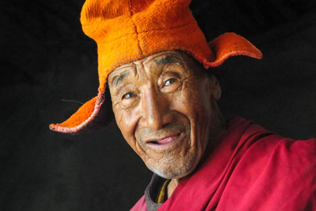
Nubra
Nubra Valley
The Nubra Valley is defined by the Shyok River, a tributary of the Indus, and the Nubra (or Siachen) River, the valley delineating the Ladakh and Karakoram ranges. The northern reaches of the Nubra Valley border Pakistan and the Siachan Glacier, both sensitive military regions often restricted to tourists. Nubra locals speak Balti (as well as Hindi), as do their neighbors in Baltistan, across the border in Pakistan. The Siachen Glacier is the second longest glacier in the world (with the exception of the polar regions), often referred to as the world’s highest and coldest battlefield, with battles over 6000 meters (which ceased after 2003).
Nubra was once an integral part of the fabled trans-Himalayan trade plied along the Silk Road for millenium, bringing great prosperity to this seemingly remote region. Caravans of camel, horse and yaks transported wool, cloth, opium, animal skins, exotic spices, dies such as indigo, and valuable stones such as turquoise, coral and of course gold. The route was treacherous, crossing high Himalayan passes connecting Leh and Yarkand until 1950 when the borders between China (Tibet) and India were sealed. The remnants of this once-important trade are the Bactrian camels, now used as vehicles to give tourists a taste of Central Asia with rides through the sand dunes between Diskit and Hunder. Nubra’s verdant groves of populars and apricots, and fields of billowing barley, all fed by the Shyok and Nubra Rivers, are an oasis in an otherwise stark environment, coloring the timeless Buddhist monasteries of Deskit, Chamba (Hunder), and Samstannling (Sumur) and Ensa, where the chanting, cymbals and horns of Buddhist monks during their morning pujas reverberate through the valley.
The people of Nubra are an interesting mix of the ethnically Tibetan Ladakhis, and Central Asian inhabitants, with blue or green eyes, fairer skin, sometimes freckles, lighter hair and more sculpted features. There are even rumors of a Greek tribe searching for the tomb of Jesus Christ in this region centuries ago, and eventually settled down in what is now known as Nubra. The locals also raise sheep and goats, as well as keeping the Bactrian camels.
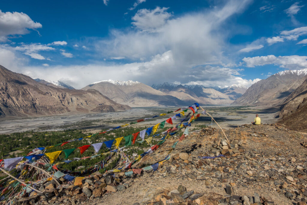
Kashmir & Srinagar
Kashmir & Srinagar
The Vale of Kashmir is one of the most prized jewels of the Indian Himalaya, described by Kashmiris as ‘heaven on earth’, famed for its floating gardens and markets on Dal & Nageen Lakes, the fascinating historic Srinagar, the pashmina weaving and other Kashmiri crafts, its heavenly Mughal Gardens, the Shankaracharya Temple and its wonderful houseboat stays.
Around Srinagar there are some of the most beautiful valleys and villages in the Indian Himalaya, as well as some of the world’s most idyllic alpine scenery. Highlights are Dacigram National Park, Manasbal & Wular Lake (the largest lake in Asia), Yousmarg, Naranag Temple (the oldest in Kashmir), Sonmarg and Pahalgam.
We’ve put together several options to tour Srinagar, Kashmir, the famous lakes with their colorful floating markets and shikaras (long-tail boats), either flying in and out of Srinagar or opting for a stunningly beautiful jeep safari over the renown Koji La pass to Leh and Ladakh for a tour of the Indus Valley and its many Buddhist monasteries. We base our tours in Srinagar, where you stay in style on traditional houseboats on the lake, visit the floating market, old Srinagar and its many mosques and markets and the famous Mughal gardens.
See our Travel Books list for recommendations of books to read on this idyllic, but politically complicated, region of Muslims and Hindu Pandits, a region which wants to be free to choose its own destiny.
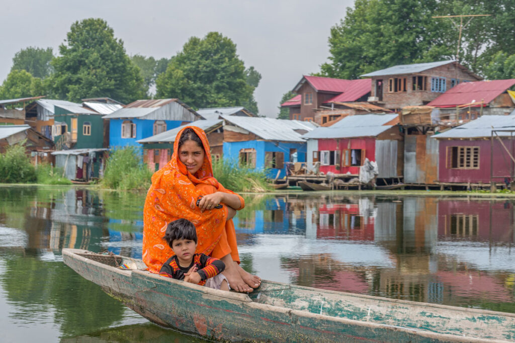
Great Stays
LADAKH | GREAT STAYS
We use Hotel Shaynam, Hotel Chospa, Hotel Padma Ladakh and Hotel Omasila as our arrival hotels, depending on availability, your budget and room preferences. We can also book any of the ‘Great Stays’ hotels for you if you’d like to treat yourself to a unique stay in Leh, or elsewhere in Ladakh. Our standard hotel is the Hotel Shaynam where Kim, Lhakpa and the Kamzang Journeys staff stay, a lovely family-run guest house with a blooming garden, deck chairs, tables and umbrellas. We don’t charge a single supplement at Hotel Shaynam, but we do charge single and upgrade supplements for Chospa, Omasila, Hotel Padma Ladakh (see Date & Price tab). Please specify your room preference when booking a trek. Breakfast included in all of the hotels.
Great Stays & Boutique-Luxury in Ladakh
We’re happy to book other hotels of your choice. Splash out on one of Leh’s most luxurious hotels! We will be happy to make any bookings needed …
Hotel Chospa
Hotel Chospa
“Hotel Chospa is a stunning retreat nestled in the heart of the vibrant city centre of Leh, located on the Old Leh Road. This enchanting abode has been curated to cater to the discerning explorer and those who appreciate the finer things in life. Chospa is the union of contemporary hospitality with the scenic and material biome of Ladakh. The architecture mirrors the traditional Ladakhi construction and materiality, rendering an ambience familiar to locals and unique for visitors.”
Dholkar Resort
Dolkhar Resort
“At Dolkhar, inspired by Ladakh’s people, culture, and traditional values, we have built a boutique stay that integrates a little piece of Ladakh with the rest of the world while keeping central our values of conscious, sustainable, and contextual travel. We create spaces that balance the familiarity of comfort with the excitement of embarking on a new journey of discovery. Dolkhar is ideally located in Tukcha at the heart of the main town, Leh – a place that was once a pit stop on the legendary silk route. The boutique stay is close enough so that you have access to everything you might need from the airport to groceries to medical facilities while still being far enough so you hear only the mountains echo.”
The Grand Dragon Ladakh
Grand Dragon Ladakh
“Established in 2007, The Grand Dragon Ladakh, one of the first 5 star hotels in Leh Ladakh, is owned and operated by the Abdu family from Leh, who have more than 40 years of experience welcoming visitors to the beautiful region. It is decorated magnificently with handmade paintings by Gulam Mustafa (the first modern artist of Ladakh) around every corner are reminiscent of royalty.”
Stok Palace Heritage Hotel
Stok Palace
“Occupying a high altar of reverence amongst the people of Ladakh, the Namgyal dynasty has resided in the Stok Palace for centuries now. Opened to the public in 1980 with the blessings of the Dalai Lama, Stok Palace today is a boutique and heritage hotel in Ladakh that encapsulates all that this mysterious and beautiful land is.”
Ladakh Sarai
Ladakh Sarai
“Ladakh Sarai started with an erstwhile adventure travel company, Tiger Tops in Stok which lies below the mighty Stok Kangri Range next to the Stok Palace.”
Chamba Camp
Chamba Camp
“Overlooking snow-capped mountains and Thiksey monastery, The Chamba Camp’s tents are superlative. With four poster beds, power showers, bespoke writing desks & private verandahs this is ‘glamping’ to the nth degree. The food is astounding: haute cuisine in high places.”
The Indus River Camp
Indus River Camp
“By day, explore the grounds, go on local hikes, visit surrounding monasteries and palaces, take in local culture or go rafting, trekking, cycling or motorbiking. Or pick a book from our well-curated library and read to the sound of flowing water. In the evening, we take guests for a riverside sunset walk, after which the milky way becomes visible with the naked eye. Sit out under the open sky by the warmth of an open fire and look out at the moon and its craters through our camp telescope.”
The Apricot Tree
The Apricot Tree
“In the most outstanding location, overlooking the flowing River Indus, Apricot Tree is a true escape. With intricate woodwork and ornate, colorful Buddhist paintings there is even a traditional Ladakhi kitchen where meals can be enjoyed. Rooms are large and bright and feature private balconies.”
Nimmu (45 minutes from Leh)
Nimmu House
Nimmu House
“Housed in a traditional Ladakhi stately home this property provides a choice between tented accommodation or rooms in the house. All are effortlessly chic combining modern muted palettes and traditional Ladakhi fabrics and textiles. The food is superb, both French and Ladakhi and all included.”
45 minutes from Leh
Saboo Resorts
Saboo Resorts
“Comprised of 15 traditional yet modern Ladakhi cottages, all with stunning mountain views. There is a restaurant serving Indian, Ladakhi and Tibetan dishes. Dining under the stars, next to the bonfire proves very popular. A perfect location for exploring the Ladakh valley”
Saboo, 30 minutes from Leh
The Unalome Resort (Diskit, Nubra)
The Unalome Resort
“The Unalome Resort is a tranquil and enchanting retreat nestled amidst the majestic landscapes of Diskit, Nubra Valley in Ladakh. Our resort offers a serene escape, allowing you to immerse yourself in the natural splendour and cultural richness of this captivating region.”
Lchang Nang Retreat (Sumur, Nubra)
Lchang Nang
“Lchang Nang retreat – The House of Trees is an eco-conscious luxury hotel and resort in Nubra Valley that celebrates local experiences, people, and culture. Located in the fabled Nubra Valley of Ladakh, on the banks of the Nubra River and on the last stop of the ancient Silk Route. The resort is the very example of a successful and sustainable eco-resort.”
Organic Boutique Hotel (Sumur, Nubra)
Organic Boutique Hotel
A beautiful hotel with large organic gardens, rooms with wooden decks or boutique tents in the willow-shaded alleys of lovely Hunder, in Nubra …
Nubra Eco Lodge (Sumur, Nubra)
Nubra Eco Lodge
“A family run ecotourism venture, located near Sumur sand dunes in the Nubra Valley. The landscape facing the confluence of Shyok and Nubra rivers is the natural habitat for seabuckthorn, wild flowers and desert wildlife. The 11 acre farm with our family home, has been planted with poplar, willow, apricot and apple trees, along with vegetable gardens. It commands a 360 degree view of the Karakoram mountains, the sand dunes and the nubra river.
A large open deck facing the valley near the vegetable garden is used as a lounge or for dining in fair weather. Ideal location to go for long walks along the Sumur sand dunes and the Nubra River. We recommend a minimum two days stay to enjoy the Nubra experience.”
Lotus Eco Resort (Sumur, Nubra)
Lotus Eco Resort
“Situated in the heart of Nubra Valley at a walking distance from the famous sand dunes. Lotus Eco Resort – The Mud House is spread in a sprawling green area of about 4 acres amidst Apricot, willow and poplar trees. Lotus Eco Resort – The Mud House has a well furnished 12 suites embedded with all the modern facilities and yet traditional in all ways, each of the suites is equipped with a beautiful fireplace and couches to sit around.”
Organic Boutique Resort (Hunder, Nubra)
Organic Boutique Resort
“A luxurious hotel which offers peaceful stay at a very attractive location near to nature”. And wonderful organic gardens, with a choice of rooms or semi-luxury tents …
Yourdum Guest House (Hundur, Nubra)
Yourdum Guest House
Pangong Sarai (Pangong Lake, Maan)
Pangong Sarai
“Just like the firefly looks for the undisturbed nature for its environment, Pangong Sarai turns into the home to the migrants in the disconnection. Pangong Tso lake is a surprising marvel in the mountains. The camps give a brave ordeal to the explorers. Climbing around the mountains, trekking and investigating the untouched land are the essentials of being here. We serve you with the flavors of Ladakh in the Pangong style to enrich you in the extreme.”
Spinney Cottage (Pangong Lake, Merak)
Spinney Cottage
“Nestled amidst the stunning landscape of Pangong Lake, our resort boasts 12 cozy wooden cottages, each offering a breathtaking view of the tranquil waters and majestic mountains.”
Ralpa Homestay (Pangong Lake, Merak)
Ralpa Homestay
“A serene retreat on the tranquil shores of Pangong Lake in Merak, Ladakh. Nestled amidst the breathtaking landscapes of the Himalayas, this cozy homestay provides guests with a blend of traditional Ladakhi hospitality and modern comforts. Visitors can enjoy stunning lake views, relish homemade Ladakhi cuisine, and experience the warmth of local culture in a peaceful and picturesque setting, making it an ideal escape for nature lovers and adventure seekers alike.”
Sakti Villa (Sakti, Wari La Chemrey Valley)
Sakti Villa
Solpon Homestay (Sakti, Wari La Chemrey Valley)
Solpon Homestay
Holiday Inn (Hanle)
Holiday Inn Hanley
“Hotel Holiday Inn Hanley is located in historic Hanle village. It is the site of the 17th century Hanle Monastery (gompa) of the Drukpa Kagyu branch of Tibetan Buddhism. Hanle is located in the Hanle River valley on an old branch of the ancient Ladakh –Tibet trade route. More recently, Hanle is the home of Hanle observatory, one of the world’s highest sites for astronomical observation.”
Tsering Angmo (Leh): 6899581464
DELHI & RAJASTHAN | GREAT STAYS
There are many great stays in Delhi and Rajasthan; we’ve listed just a few …
Delhi & Rajasthan | 5-Star Hotels
If you want to treat yourself at a five-star hotel, book a room at The Imperial Hotel, the Taj Mahal or the Aman Resort before or after the trek. It’s a great way to wind down from travels or after a trek! All have spas, pools, gardens and many world-class cafes, restaurants and bars within the air conditioned complexes. Room rates vary considerably depending on the season.
The Imperial ($$$)
The Imperial
Taj Mahal Hotel ($$$$)
Taj Mahal
Aman Resorts ($$$$)
Aman Resorts
Delhi | Stylish Hotels
Easy choices …
Bloom Rooms ($$-$$$)
Bloom Rooms
Colonel’s Retreat ($$-$$$)
Colonel’s Retreat
Ahuja Residences ($$$)
Ahuja Residences
Lutyens Bungalow ($$)
Lutyens Bungalow
Delhi | Homestays
Homestays are increasingly becoming popular in Delhi. Search on-line for a good one; they usually provide breakfast, and dinner if requested.
Photos
KIM BANNISTER PHOTOGRAPHY | HIMALAYAN TREKS, CYCLE TRIPS & TRAVELS
Kim Bannister Photography
CYCLE THE HIMALAYA PHOTOS
Guided Cycling Trips
KAMZANG JOURNEYS | ALL ABOUT US IN PHOTOS
Explore Kamzang Journeys
KAMZANG JOURNEYS | YELLOW TENT PHOTOS
The Yellow Tent of Eternal Happiness
HIMALAYAN WILDLIFE, BIRDS & FLOWERS PHOTOS
Himalayan Wildlife, Birds & Plants
HIMALAYAN DESIGN & CULTURAL PHOTOS
Himalayan Design & Cultural Photos
KAMZANG JOURNEYS GROUP PHOTOS
Kamzang Journeys Groups
KAMZANG JOURNEYS STAFF PHOTOS
Kamzang Journeys Staff
THE KAMZANG FUND & KAMZANG KIDS PHOTOS
The Kamzang Fund
NEPAL JOURNEYS PHOTOS
Nepal Journey
INDIA JOURNEY PHOTOS
India Journeys
TIBET JOURNEYS PHOTOS
Tibet Journeys
BHUTAN JOURNEYS PHOTOS
Bhutan Journeys
MYANMAR (BURMA) JOURNEYS PHOTOS
Myanmar (Burma) Photos
MONGOLIA JOURNEYS PHOTOS
Mongolia Journeys
SOUTHEAST ASIA PHOTOS
South East Asia Photos